
Neville Township, Pennsylvania
Neville Township | |
|---|---|
Township | |
EDT) | |
| ZIP code | 15225 |
| Area code | 412 |
| School District | Cornell |
Neville Township is a township in Allegheny County, Pennsylvania, United States. Its land area consists entirely of Neville Island, which is an island on the Ohio River. The population was 1,108 at the 2020 census.[2]
History
The
The township was incorporated on April 8, 1854, from a part of Ohio Township.[3] It obtained first-class status in 1901.[4]
A 1903 newspaper advertisement for real estate on the island promoted it as the next Manhattan Island.[5]
Island Sports Center
In 1998, the Hillman Company built the
Geography
The township boundary encompasses Neville Island and a surrounding portion of the Ohio River.[6] According to the United States Census Bureau, the township has a total area of 2.2 square miles (5.7 km2), of which 1.3 square miles (3.4 km2) is land and 0.9 square miles (2.3 km2) (40.36%) is water. The island, nearly five miles long, is the largest by land area in Pennsylvania.
Government and politics
| Year | Republican | Democratic | Third parties |
|---|---|---|---|
| 2020 | 50% 286 | 48% 276 | 1% 8 |
| 2016 | 50% 260 | 44% 225 | 6% 31 |
| 2012 | 48% 245 | 52% 267 | 1% 3 |
Adjacent neighborhoods
Across the Ohio River's back channel, Neville Township runs adjacent with (from northwest to southeast)
Across the river's main channel, Neville Township runs adjacent with (from northwest to southeast)
The
Demographics
| Census | Pop. | Note | %± |
|---|---|---|---|
| 1860 | 236 | — | |
| 1870 | 289 | 22.5% | |
| 1880 | 306 | 5.9% | |
| 1890 | 353 | 15.4% | |
| 1900 | 758 | 114.7% | |
| 1910 | 634 | −16.4% | |
| 1920 | 1,272 | 100.6% | |
| 1930 | 1,532 | 20.4% | |
| 1940 | 1,469 | −4.1% | |
| 1950 | 2,310 | 57.2% | |
| 1960 | 2,400 | 3.9% | |
| 1970 | 2,017 | −16.0% | |
| 1980 | 1,416 | −29.8% | |
| 1990 | 1,273 | −10.1% | |
| 2000 | 1,232 | −3.2% | |
| 2010 | 1,084 | −12.0% | |
| 2022 (est.) | 1,079 | [2] | |
| U.S. Decennial Census[10][11][12][13][14][15][16] | |||
As of the 2000 census,[17] there were 1,232 people, 624 households, and 313 families residing in the township. The population density was 929.4 inhabitants per square mile (358.8/km2). There were 676 housing units at an average density of 510.0 per square mile (196.9/km2). The racial makeup of the township was 97.32% White, 1.22% Black or African American, 0.08% Native American, 0.32% from other races, and 1.06% from two or more races. Hispanic or Latino of any race were largely irrelevant.
There were 624 households, out of which 20.4% had children under the age of 18 living with them, 34.8% were married couples living together, 11.2% had a female householder with no husband present, and 49.7% were non-families. 43.8% of all households were made up of individuals, and 18.3% had someone living alone who was 65 years of age or older. The average household size was 1.97 and the average family size was 2.75.
In the township the population was spread out, with 18.3% under the age of 18, 9.0% from 18 to 24, 27.4% from 25 to 44, 23.3% from 45 to 64, and 22.0% who were 65 years of age or older. The median age was 42 years. For every 100 females, there were 94.9 males. For every 100 females age 18 and over, there were 89.6 males.
The median income for a household in the township was $30,625, and the median income for a family was $44,083. Males had a median income of $31,827 versus $26,838 for females. The
Gallery
-
 Neville Township Municipal Building, located at 5050 Grand Avenue.
 -
 The Neville Motel Bungalows, probably date back to the 1940s or 1950s, located near the corner of Neville Road and Grand Avenue.
 -
 Island Sports Center, built in 1998, located at 7600 Grand Avenue.
 -
 A portion of Neville Island, PA, on October 17, 2009.
 -
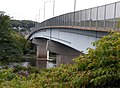
 The Neville Island Bridge, opened in 1976.
 -
 The Coraopolis-Neville Island Bridge, which opened in 1995, replaced the former Coraopolis Bridge.
 -
 The Fleming Park Bridge, built in 1955.
 -
 The PC&Y Railroad Bridge, built in 1894.
 -
 The Neville Township Memorial in Memorial Park on Grand Avenue.
 -
 The Becky Thatcher docked on Neville Island on October 17, 2009.


References
- ^ "2016 U.S. Gazetteer Files". United States Census Bureau. Retrieved August 13, 2017.
- ^ a b c d "City and Town Population Totals: 2020-2022". Census.gov. US Census Bureau. Retrieved June 13, 2023.
- ^ Negley, W. B. (1876). "Allegheny County; its Formation, its Cities, Wards, Boroughs and Townships". Atlas of the County of Allegheny, Penna. Philadelphia: G.M. Hopkins & Co. p. 4.
- ^ "Allegheny County - 2nd Class" (PDF). Retrieved July 18, 2017.
- ^ "The Pittsburgh Press - Google News Archive Search". news.google.com.
- ^ "Allegheny County GIS Data Viewer". Retrieved February 26, 2016.
- ^ EL. "2012 Allegheny County election". Pittsburgh Tribune-Review. Retrieved October 15, 2017.
- ^ EL. "2016 Pennsylvania general election..." Pittsburgh Post-Gazette. Retrieved October 15, 2017.
- ^ "Election Night Reporting".
- ^ "Census of Population and Housing". Census.gov. Retrieved June 4, 2016.
- ^ "1850-1870 Population" (PDF).
- ^ "1870-1880 Population" (PDF).
- ^ "1890-1910 Population" (PDF).
- ^ "1910-1930 Population" (PDF).
- ^ "1940-1960 Population" (PDF).
- ^ "1970-1990 Population" (PDF).
- ^ "U.S. Census website". United States Census Bureau. Retrieved January 31, 2008.
