
Homestead, Pennsylvania
This article needs additional citations for verification. (July 2007) |
Homestead, Pennsylvania | |
|---|---|
EDT) | |
| ZIP Code | 15120 |
| Area code | 412 |
| FIPS code | 42-35424 |
| Website | www |
Homestead is a
History

The area on the south bank of the
Homestead gained international notoriety in July 1892 as the site of a violent clash between locked-out steelworkers and hired Pinkerton guards, known as the

To break the strike and secure the mill from the disgruntled workers, industrialist
At the turn of the 20th century, in 1900, the population of Homestead was 12,554 people, of whom some 7,000 were employed in the plants. Due mostly to immigration from

In 1940, 19,041 people lived in Homestead. During the early 1940s half the population was displaced as the United States government added to the steel mills to have the capacity for armor plating for ships and tanks (preparing for World War II).[5] After the end of the war, a decline in the steel-making industry of the United States took place.
By 1980, it had become difficult to obtain employment at the Homestead Works, which was not producing much steel at that time. In 1986, the mill closed. The Homestead Works was demolished in the early 1990s, replaced in 1999 by The Waterfront shopping mall. As a direct result of the loss of mill employment, the number of people living in Homestead dwindled. By the time of the 2010 census, the borough population was 3,165. The borough began financially recovering in 2002, with the enlarging retail tax base.
Geography
Homestead is located at 40°24′18″N 79°54′28″W / 40.40500°N 79.90778°W (40.405069, −79.907785).[6] According to the U.S. Census Bureau, the borough has a total area of 0.6 square miles (1.6 km2), of which 0.6 square miles (1.6 km2) is land and 0.1 square miles (0.26 km2), or 11.11%, is water.
Surrounding neighborhoods
Homestead has two land borders, including
Demographics
| Census | Pop. | Note | %± |
|---|---|---|---|
| 1880 | 592 | — | |
| 1890 | 7,911 | 1,236.3% | |
| 1900 | 12,554 | 58.7% | |
| 1910 | 18,713 | 49.1% | |
| 1920 | 20,452 | 9.3% | |
| 1930 | 20,141 | −1.5% | |
| 1940 | 19,041 | −5.5% | |
| 1950 | 10,046 | −47.2% | |
| 1960 | 7,502 | −25.3% | |
| 1970 | 6,309 | −15.9% | |
| 1980 | 5,092 | −19.3% | |
| 1990 | 4,179 | −17.9% | |
| 2000 | 3,569 | −14.6% | |
| 2010 | 3,165 | −11.3% | |
| 2020 | 2,884 | −8.9% | |
| Sources:[7][8][9][10][11][3] | |||
As of the 2000 census,[8] there were 3,569 people, 1,607 households, and 843 families residing in the borough. The population density was 6,281.6 inhabitants per square mile (2,425.3/km2). There were 2,071 housing units at an average density of 3,645.0 per square mile (1,407.3/km2). The racial makeup of the borough was 42.64% White, 51.30% African American, 0.25% Native American, 2.83% Asian, 0.03% Pacific Islander, 0.22% from other races, and 2.72% from two or more races. Hispanic or Latino of any race were 0.62% of the population.
There were 1,607 households, out of which 24.4% had children under the age of 18 living with them, 23.3% were married couples living together, 24.4% had a female householder with no husband present, and 47.5% were non-families. 42.5% of all households were made up of individuals, and 19.4% had someone living alone who was 65 years of age or older. The average household size was 2.16 and the average family size was 2.99.
In the borough, the population was spread out, with 24.2% under the age of 18, 8.0% from 18 to 24, 25.1% from 25 to 44, 23.8% from 45 to 64, and 18.9% who were 65 years of age or older. The median age was 40 years. For every 100 females, there were 80.1 males. For every 100 females age 18 and over, there were 75.1 males.
The median income for a household in the borough was $16,603, and the median income for a family was $28,314. Males had a median income of $25,500 versus $21,559 for females. The
Arts and culture
Much of Homestead and some of the surrounding communities are listed on the
The Carnegie Library of Homestead was opened to the public in 1898. It was the sixth library commissioned by Andrew Carnegie in the U.S. and the seventh to open. It is the third oldest Carnegie library in continuous operation in its original structure in the U.S. after the Main Branch and Lawrenceville Branch of Pittsburgh.[14]
The historic
In 2000, Continental Real Estate Companies opened The Waterfront, a super-regional open air shopping mall built on the former site of the Homestead Steel Works. Most of the structures associated with the steel mills on this site were demolished during construction, although some of the brick stacks from the mill still stand. In addition, near the river is a former mill structure known as the Pump House which was restored by the developer.
The Great Allegheny Passage, part of a shared-use path connecting Pittsburgh to Washington, D.C., runs through the borough parallel to the river.
Government and politics
| Year | Republican | Democratic | Third parties |
|---|---|---|---|
| 2020 | 13% 205 | 85% 1,276 | 0.7% 11 |
| 2016 | 11% 166 | 87% 1,270 | 4% 23 |
| 2012 | 8% 129 | 91% 1,396 | 1% 5 |
Transportation
An important state route,
Homestead is served by three railroads: the
Notable people
- NFL quarterback for the Detroit Lions and Pittsburgh Steelers
- William Campbell, business executive
- John S. Crawford, member of the Wisconsin State Assembly
- Betty Davis, singer, songwriter, and model
- Mary Dee, radio personality and disc jockey
- Nora Barry Fischer, U.S. district judge for the Western District of Pennsylvania
- Jeff Goldblum, actor
- Jester Hairston, composer, choral conductor and actor
- Orrin Hatch - former Utah senator and President pro tempore of the U.S. Senate
- Butch Leitzinger, racing driver
- Curt Leskanic, Major League Baseball player for the Colorado Rockies, Milwaukee Brewers, Kansas City Royals, and the Boston Red Sox
- Frank McHugh, actor of stage, film, and television, was born in Homestead in 1898.
- Joe Mihal, pro football player
- Eisner Awardwinner
- Cumberland Posey, basketball player and Negro league baseball owner, member of both Baseball and Basketball Halls of Fame
- John Rice, MLB umpire
- Maxine Sullivan, jazz singer
- Jim Tomsula, Former NFL head coach for the San Francisco 49ers
- Tamara Tunie, actress
- Hamilton Tiger Cats
Gallery
-
 Homestead Pennsylvania Railroad Station, built circa 1890, on Amity Street in Homestead
 -
 St. Mary Magdalene Church, built 1895, at 1008 Amity Street in Homestead
 -
 Carnegie Library of Homestead, built from 1896 to 1898, located in the Homestead Historic District in Munhall
 -
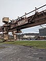 Gantry crane at the site of Homestead Steel Works


References
- ^ https://www.cbsnews.com/pittsburgh/news/john-burwell-sworn-in-as-first-black-mayor-in-homestead-history/
- ^ "ArcGIS REST Services Directory". United States Census Bureau. Retrieved October 12, 2022.
- ^ a b "Census Population API". United States Census Bureau. Retrieved October 12, 2022.
- ^ "Census - Geography Profile: Homestead borough, Pennsylvania". United States Census Bureau. Retrieved April 24, 2022.
- ^ Miner, Curtis; Roberts, Paul (February 10, 2015). "Engineering an Industrial Diaspora: Homestead, 1941". Western Pennsylvania History: 1918 - 2018. Pittsburgh History: 4–25. Retrieved February 10, 2015.
- ^ "US Gazetteer files: 2010, 2000, and 1990". United States Census Bureau. February 12, 2011. Retrieved April 23, 2011.
- ^ "1990 Population and Housing Counts". US Census Bureau. Retrieved November 22, 2013.
- ^ a b "U.S. Census website". United States Census Bureau. Retrieved January 31, 2008.
- ^ "Number of Inhabitants: Pennsylvania" (PDF). 18th Census of the United States. U.S. Census Bureau. Retrieved November 22, 2013.
- ^ "Annual Estimates of the Resident Population". U.S. Census Bureau. Archived from the original on October 19, 2013. Retrieved November 22, 2013.
- ^ "Number of Inhabitants-Pennsylvania" (PDF). Seventeenth Census of the United States. U.S. Census Bureau. Retrieved November 22, 2013.
- ^ James, Earl D.; Walter Kidney; Lu Donnelly; Patricia Sands (1990). "Homestead Historic District" (PDF). National Register of Historic Places Nomination Form. Pennsylvania Historical and Museum Commission. Retrieved January 9, 2014.
- ^ Gerald M. Kuncio and John W. Bond (March 17, 1998). "National Register of Historic Places Inventory-Nomination: Bost Building / Columbia Hotel" (pdf). National Park Service.
{{cite journal}}: Cite journal requires|journal=(help) - ^ Historic Landmark Plaques 1968-2009 (PDF). Pittsburgh, PA: Pittsburgh History & Landmarks Foundation. 2010. Retrieved July 2, 2010.
- ^ "St. Nicholas Orthodox Church ::: St. Nicholas Center".
- ^ EL. "2012 Allegheny County election". Pittsburgh Tribune-Review. Retrieved October 15, 2017.
- ^ EL. "2016 Pennsylvania general election results". Pittsburgh Post-Gazette. Retrieved October 15, 2017.
- ^ "Election Night Reporting".
Further reading
- Byington, Margaret F., and Samuel P. Hays. Homestead: The Households of a Mill Town. Pittsburgh: University of Pittsburgh Press (1974). ISBN 0822982501
- Serrin, William. Homestead: The Glory and Tragedy of an American Steel Town. New York: Vintage (1993). ISBN 0679748172
- Modell, Judith, and Charlee Brodsky. A Town Without Steel: Envisioning Homestead. Pittsburgh: University of Pittsburgh Press (1998). ISBN 0822956764
External links
- Homestead, Pennsylvania, 1902 from the Library of Congress via the World Digital Library
- BattleOfHomestead.org
- HomesteadHebrews.com
- SteelValleyAvenues.com

| International | |
|---|---|
| National | |
| Geographic | |
| Other | |