Oder–Spree Canal
| Oder–Spree Canal | |
|---|---|
 A lock on the Oder-Spree Canal in Wernsdorf | |
| Location | Berlin |
| Country | Germany |
| Coordinates | 52°22′40″N 13°40′32″E / 52.37778°N 13.67556°E |
| Specifications | |
| Length | 20 km (12 miles) |
| History | |
| Date completed | 1891 |
| Geography | |
| Direction | East-west |
| Start point | River Oder, at Eisenhüttenstadt |
| End point | River Dahme river, at Schmöckwitz |
| Beginning coordinates | 52°08′52″N 14°40′57″E / 52.1479°N 14.6824°E |
| Ending coordinates | 52°22′45″N 13°40′08″E / 52.3791°N 13.6690°E |

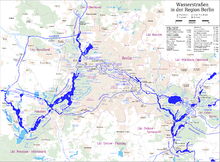
The Oder–Spree Canal (German: Oder-Spree-Kanal pronounced [ˌoːdɐˈʃpʁeː.kaˌnaːl] ⓘ), is a canal in the east of Germany. It links the Dahme river, at Schmöckwitz in the south-eastern suburbs of Berlin, with the River Oder, at Eisenhüttenstadt. It provides an important commercial navigable connection between Berlin and the Oder, and hence Poland.[1]
The canal has several connections to the
References
- ^ ISBN 0-85288-283-1.
Wikimedia Commons has media related to Oder-Spree-Kanal.
