
Merritt Parkway
Merritt Parkway | |
|---|---|
 Merritt Parkway highlighted in red | |
| Route information | |
| Maintained by CTDOT | |
| Length | 37.67 mi[1] (60.62 km) |
| Existed | June 29, 1938–present |
| Tourist routes | |
| Restrictions | No commercial vehicles[2] |
| Major junctions | |
| South end | |
| North end | Wilbur Cross Parkway / Milford Parkway in Milford |
| Location | |
| Country | United States |
| State | Connecticut |
| Counties | Fairfield, New Haven |
| Highway system | |
| |
Merritt Parkway | |
| Architect | Connecticut Highway Department; et al. |
| Architectural style | Colonial Revival, Classical Revival, Modern Movement |
| NRHP reference No. | 91000410 |
| Added to NRHP | April 17, 1991[3] |


The Merritt Parkway (also known locally as "The Merritt") is a
Trucks, buses, trailers, towed vehicles, and all vehicles 8 feet (2.4 m) tall or taller are not allowed on any part of the parkway due to its low bridges, narrow lanes, and tight curve radii.
The roadway sign of the Merritt features a blue shield with white lettering, along with the foliage of Kalmia latifolia, commonly known as the mountain laurel, the state flower of Connecticut.
Route description

The Merritt is one of a handful of United States highways listed in the National Register of Historic Places. It is acknowledged for the beauty of the forest through which it passes, as well as the architectural design of its overpasses; at the time of its construction, each bridge was decorated in a unique fashion so that no two bridges on the parkway looked alike.[7] Newer overpasses used at exit 39 (US 7), though, did not maintain this tradition, and as a result, exit 39 on the parkway is now spanned by several ordinary modern bridges constructed using undecorated concrete-on-steel I-beams.[8]
The parkway has two lanes in each direction. Due to its age, it was originally constructed without the merge lanes, long on-ramps, and long off-ramps that are found on modern freeways. Some entrances have perilously short and/or sharp ramps; some entrances even have stop signs, with no merge lane whatsoever; this leads to some dangerous entrances onto the highway. Most have since been modernized, with the interchange of
Vehicles 8 feet (2.4 m) tall or taller in height, weighing 8,000 pounds (3,600 kg) or more, towing a trailer, or having more than four wheels are not allowed on the parkway. Under extenuating circumstances, however, ConnDOT may issue permits for oversized vehicles to use the parkway.[12][2]
History


The Merritt Parkway is one of the oldest scenic
After the parkway fully opened in 1940, travelers commonly stopped to picnic along the side of the road.[16] The Merritt Parkway Advisory Commission (later the Merritt Parkway Advisory Committee) decided to ban horses and buggies, bicycles, pedestrians, billboards, and U-turns, while a system of horse trails along the parkway was developed, but later abandoned.[17]
To ease objections from county residents, who feared an influx of New Yorkers on their roads, in their towns, on their beaches, and through their forests, highway planners called on engineers, landscape architects, and architects to create a safe and aesthetically pleasing limited-access highway, one with exit and entrance ramps, but no intersections, that would not spoil the countryside.[18][19]
The bridges played a prominent role in the design. Architect George L. Dunkelberger designed them all. They reflected the popularity of the Art Deco style, with touches of neoclassical and modern design.[20][21][22] Some of these bridges were constructed by the Works Progress Administration.

Tolls were collected on the parkway at one toll plaza in
In April 2001, a complete reissuance of the parkway's signs was carried out, instituting a uniform white-on-green color scheme, and a sawtooth border.[23][24][25]
Services
Six rest areas/service plazas, featuring parking lots, gas stations, and convenience stores, were also built along the Merritt Parkway so that drivers would not have to exit to refuel. Pairs of plazas are located opposite each other on either side of the parkway in Fairfield (near exit 46), New Canaan (near exit 37), and Greenwich (just beyond the CT-NY state line). The northbound-side plaza in Greenwich also houses a Connecticut welcome center. The plazas were originally constructed during the parkway's days as a tolled highway, but remained even after the tolls were removed in 1988, making the parkway one of only a few toll-free highways with service plazas along its length. Between 2011 and 2015, all six of the service plazas (along with the four located further north along the Wilbur Cross Parkway) were completely renovated. The renovations preserved the original brick-and-stone façade of the buildings, but completely redesigned and modernized the interiors. The plazas now include more modern gas pumps, Alltown convenience stores, and a Dunkin' Donuts shop at each location; three of the Merritt's six plazas also include a Subway shop. Prior to the renovations, no fast-food service had previously been available at the plazas. The renovation project was completed during the summer of 2015, when the New Canaan plazas were reopened.[citation needed]
In 2013, electric-vehicle (EV) charging stations for
Safety

This section needs additional citations for verification. (January 2020) |
One of the Merritt's aesthetic features is also a potential danger to its drivers. Trees that line either side of the parkway, and often in the center median, grow branches that cover the roadway, and occasionally fall during severe weather, or with natural aging. Stretches of the parkway also lack guardrails on the right shoulders, creating a risk of tree-impact accidents if cars veer off the pavement.
In 2007, after complaints were voiced about the danger of the trees along the parkway, state officials announced they would trim and eliminate some of them more aggressively. A large, seemingly healthy tree fell on a car near exit 42 in Westport in June 2007, killing a couple from Pelham, New York. On June 23, 2011, a driver was killed in Stamford when a tree fell onto his car.[27]
A state study of fatalities on Connecticut highways showed that from 1985 to 1992, about 10 people died every three years in tree-related accidents, although no other state roadway averaged more than one in three years.
The state Department of Transportation commonly sends out work crews twice a year to drive along both sides of the parkway at 5 miles per hour (8.0 km/h) in search of decrepit trees. Trees that had been scheduled to be cut down in five to 10 years would be removed sooner. Some more trees also would be removed, as the shoulder of the parkway is being widened to 8 feet (2.4 m) to give drivers room to pull over.[28]
Following the 2007 and 2011 incidents, the state became more aggressive in closing the parkway in times of severe weather. The parkway was closed during Tropical Storm Irene[29] and the Halloween nor'easter in 2011, and Hurricane Sandy in 2012. With each of those storms, many trees and limbs fell across the parkway. After Sandy, the state began a large effort to remove unhealthy trees, and in the process created much wider clearances between the roadside and forest.[27]
The Merritt Parkway Advisory Committee meets quarterly.[28][30]
Future
This section needs to be updated. (December 2021) |
ConnDOT is currently reviewing plans and holding community meetings over a redesign of the Merritt's interchange with
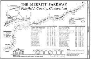
Exit list
Like most highways in Connecticut, exits are numbered sequentially, not mile-based, though the state is gradually transitioning to milepost-based exit numbers. Exit numbers on the Merritt Parkway continue from the original sequential exits of the Hutchinson River Parkway, which ended at 27;[5]: 15 since 2021, the Hutchinson River Parkway has used a mileage-based system ending at 19A.[34] King Street (NY 120A), which travels along the state border, is served by exit 27 on the Merritt Parkway and exit 19A on the Hutchinson River Parkway. Prior to 2021, because additional interchanges had been added on the New York side, exit 19A on the Hutchinson River Parkway was numbered as exit 30.
| County | Location | mi[1] | km | Old exit | New exit | Destinations | Notes |
|---|---|---|---|---|---|---|---|
| Fairfield | Greenwich | 0.00 | 0.00 | – | – | Continuation into New York | |
| 0.05 | 0.080 | 27 | 19B | Armonk, NY | Access to NY 120A south via Hutchinson Parkway exit 19A;[35] exit no. corresponds to Hutchinson Pkwy. | ||
| 3.39 | 5.46 | 28 | 3 | Round Hill Road | To Greenwich Business District | ||
| 4.16 | 6.69 | 29 | 4 | Lake Avenue | |||
| 30 | – | Butternut Hollow Road | At-grade intersection; intersection closed 1955[36] | ||||
| 5.71 | 9.19 | 31 | 5 | North Street | To Greenwich Business District | ||
| Stamford | 8.89 | 14.31 | 33 | 8 | Den Road | Right-in/right-out connections only | |
| 9.22 | 14.84 | 34 | 9 | To Downtown Stamford and University of Connecticut Stamford Campus | |||
| 10.40 | 16.74 | 35 | 10 | ||||
| New Canaan | 13.15 | 21.16 | 36 | 13 | |||
| 13.89– 14.10 | 22.35– 22.69 | 37 | 14 | ||||
Norwalk Community College | |||||||
| 16.87– 17.31 | 27.15– 27.86 | 39 | 16-17A | Northbound exit and southbound entrance; signed as exits 16 (south) and 17A (north); redesign in proposal stage[31] | |||
| 17.53– 17.63 | 28.21– 28.37 | 40 | 17 | Signed as exits 17A (south) and 17B (north) southbound, exits 17B (south) and 17C (north) northbound; US 7 not signed northbound | |||
| Westport | 20.73 | 33.36 | 41 | 20 | |||
| 21.59 | 34.75 | 42 | 21 | ||||
| Fairfield | 26.95 | 43.37 | 44 | 27 | To Fairfield Business District and Fairfield University | ||
| 28.58 | 46.00 | 46 | 28 | To West Campus of Sacred Heart University, formerly General Electric Headquarters[37] | |||
| Trumbull | 29.31 | 47.17 | 47 | 29 | Park Avenue | To University of Bridgeport and Sacred Heart University | |
| 30.37 | 48.88 | 48 | 30 | Single-point urban interchange | |||
| 31.64– 32.69 | 50.92– 52.61 | 49 | 32A | Signed as exits 31 (south) and 32 (north) northbound; no southbound access to Route 25 south; exits 5A-B on Route 25 | |||
| 32.99 | 53.09 | 50 | 32B | Southbound exit and northbound entrance | |||
| 33.51 | 53.93 | 51 | 33 | Northbound exit and southbound entrance | |||
| 33.77– 34.57 | 54.35– 55.64 | 52 | 34 | No northbound access to Route 8 south/Route 108; exits 5-6 on Route 8 | |||
| Stratford | 36.54 | 58.81 | 53 | 36 | |||
| Housatonic River | 37.53 | 60.40 | Igor I. Sikorsky Memorial Bridge | ||||
| New Haven | Milford | 37.67 | 60.62 | 54 | 37 | Access via Milford Parkway | |
| – | – | Wilbur Cross Parkway) – Hartford | Continuation north | ||||
1.000 mi = 1.609 km; 1.000 km = 0.621 mi
| |||||||
In popular culture
- The Willem de Kooning oil-on-canvas painting Merritt Parkway (1959) is owned by the Detroit Institute of Arts.[38][39]
- Lisa Seidenberg, a filmmaker from Westport, produced a documentary film, The Road Taken...The Merritt Parkway (2008).[40]
Images
-
 Map (western segment)
 -
 Map (eastern segment)
 -
 Talmadge Hill Metro-North station over the Merritt in New Canaan
.jpg)
.jpg)

See also
 U.S. Roads portal
- Merritt Parkway Bridges
- National Register of Historic Places listings in Fairfield County, Connecticut
- Connecticut Route 15
References
- ^ a b Connecticut Department of Transportation (2012). "2012 Traffic Volumes, State Maintained Highway Network" (PDF). Connecticut Department of Transportation. Retrieved January 27, 2020.
- ^ a b "What is allowed to travel on the Merritt Parkway?". Connecticut Department of Transportation. Archived from the original on November 3, 2017. Retrieved August 24, 2007.
- ^ "National Register Information System". National Register of Historic Places. National Park Service. January 23, 2007.
- ^ "Connecticut: Fairfield County Historic Places". National Register of Historic Places. Archived from the original on August 17, 2017. Retrieved August 24, 2007.
- ^ a b Shannahan, John W. (April 17, 1991). "National Register of Historic Places in America". Retrieved March 14, 2020.
National Park Service Certification I, hereby, certify that this property is: entered in the National Register [signed Beth L. Savage] 4-17-91[...]The Merritt Parkway, Connecticut's ALL-YEAR GATEWAY TO NEW ENGLAND, Welcome to our State. We want you to enjoy your stay here and to come again. [signed Raymond E. Baldwin ] Governor
- ^ "America's 11 Most Endangered Historic Places". National Trust for Historic Preservation. Archived from the original on May 22, 2010. Retrieved May 23, 2010.
- ^ Lynn, Catherine; Wigren, Christopher (February 22, 1991). "National Register of Historic Places Registration Form: Merritt Parkway" (PDF). National Park Service. Retrieved February 12, 2015. Photos
- ^ "Steel Structure" (PDF). Connecticut Department of Transportation. Archived (PDF) from the original on February 21, 2017. Retrieved July 12, 2018.
- ^ "Traffic: A Guide to the Pure Chaos of the Merritt Parkway". DimeBrothers. Archived from the original on July 10, 2011. Retrieved February 18, 2008.
- ISBN 0-300-05379-7. Retrieved February 18, 2008.
- ^ Fenster, Jordan (March 26, 2019). "Why is there no Exit 43 on the Merritt Parkway?". The News-Times. Archived from the original on April 6, 2019. Retrieved April 6, 2019.
- ^ "Connecticut Parkways: Vehicles Prohibited from Connecticut Route 15 (Merritt Parkway and Wilbur Cross Parkway) between the New York State Line & I-91 in Meriden, CT and State Route 796 (Milford Parkway)". Connecticut Department of Transportation. January 15, 2020. Archived from the original on March 14, 2020. Retrieved March 14, 2020.
- ^ "Connecticut Scenic Drives: Merritt Parkway". HowStuffWorks. April 12, 2007. Archived from the original on July 12, 2018. Retrieved July 12, 2018.
- ^ "The Merritt Parkway". Hartford Courant. p. 10.
- ^ "CT's In A Jam, But More Road Capacity Isn't The Answer". Hartford Courant. Archived from the original on July 12, 2018. Retrieved July 12, 2018.
- ISBN 978-0-7385-3458-9.
- ISBN 0-300-05379-7.
- ^ "Merritt Parkway Preservation Landscape". Connecticut Department of Transportation. Retrieved March 14, 2020.
- ^ Fazzalaro, James J. (May 17, 2002). Merritt Parkway Traffic Accident Analysis. Connecticut General Assembly Office of Legislative Research. 2002-R-0501. Retrieved March 14, 2020.
- ^ "Local Legacies — The Merritt Parkway". Library of Congress. 2000. Archived from the original on October 4, 2007.
- ^ Roth, Charles R. "The Merritt Parkway: The Queen of All Parkways". Trumbull, Connecticut: Trumbull Historical Society. Archived from the original on October 2, 2007. Retrieved October 4, 2007.
- ^ "A Scenic Roadway that Bridges Many Divides". Hartford Courant. Archived from the original on January 19, 2013. Retrieved January 24, 2007.
- ^ "Historical Merritt Parkway Images". Connecticut Department of Transportation. 2016. Retrieved March 14, 2020.
- ^ "Merritt Parkway Signage to be Replaced". Connecticut Department of Transportation. April 13, 2017. Retrieved March 14, 2020.
- ^ Shay, Jim (April 12, 2017). "State plans to replace signs on Merritt Parkway". Connecticut Post. Archived from the original on April 16, 2017. Retrieved March 14, 2020.
- ^ "EV Charging Stations" (PDF). Archived (PDF) from the original on June 5, 2019. Retrieved June 5, 2019.
- ^ a b Cassidy, Martin B. (December 15, 2012). "State eliminates storm-weakened Merritt trees". Danbury News-Times. Archived from the original on February 26, 2014. Retrieved December 17, 2012.
- ^ The Advocate(Norwalk ed.). Stamford, Connecticut. pp. 1, A4.
- ^ "Irene knocks out power, downs trees on approach". WTNH-TV. August 28, 2011. Archived from the original on September 18, 2011. Retrieved September 1, 2011.
- ^ "Merritt Parkway Preservation Landscape". CT.gov — Connecticut's Official State Website. Retrieved November 15, 2020.
- ^ a b "Route 7/15 Norwalk Project". Archived from the original on March 28, 2019. Retrieved May 22, 2019.
- ^ "The US 7-CT 15 Interchange". Merritparkway.org. Archived from the original on June 5, 2019. Retrieved May 22, 2019.
- ^ Krasselt, Kaitlyn (January 11, 2017). "DOT Explains Route 7/15 Interchange Project". The Hour. Archived from the original on January 13, 2017. Retrieved May 22, 2019.
- ^ "Old numbers make their exit on Hutchinson River Parkway". Pelham Examiner. July 23, 2021. Retrieved August 5, 2021.
- ^ "Hutchinson River Parkway Guide Signs, Bruckner Interchange to Connecticut Line, S.H. Various, Bronx, Westchester Counties, Contract D264231". New York State Department of Transportation. January 31, 2020. Retrieved July 11, 2021.
- ^ "Crossover to be Closed". The Daily Item. Port Chester, New York. November 16, 1955. p. 6. Retrieved May 9, 2021 – via Newspapers.com.
- ^ Grice, Jordan (September 14, 2018). "Sacred Heart Settling into Former GE Headquarters". Connecticut Post. Archived from the original on September 13, 2018. Retrieved March 14, 2020.
- ^ Willem de Kooning, Merritt Parkway, 1959 Archived September 23, 2015, at the Wayback Machine, AMICA (Art Museum Images from Cartography Associates) Library.
- ^ Content is a Glimpse: March 1960: Interview with David Sylvester, recorded March 1960 Archived May 18, 2015, at the Wayback Machine, Willem de Kooning Foundation.
- ^ "The Road Taken...The Merritt Parkway". Westport Historical Society. October 6, 2008. Archived from the original on May 18, 2015.
Further reading
- Radde, Bruce (1993). The Merritt Parkway. New Haven, Connecticut: ISBN 0-300-06877-8.
- Larned, Larry (1998). Traveling the Merritt Parkway. Charleston, S.C.: Arcadia. ISBN 0-7524-0946-8.
All of the following are filed under Fairfield County, CT:
- HAER No. CT-63, "Merritt Parkway, Beginning in Greenwich & running 38 miles to Stratford", 119 photos, 21 measured drawings, 160 data pages, 8 photo caption pages
- HAER No. CT-131, "Merritt Parkway, Greenwich (Northbound) Service Station", 2 photos, 3 data pages, 1 photo caption page
- HAER No. CT-132, "Merritt Parkway, Greenwich (Southbound) Service Station", 2 photos, 3 data pages, 1 photo caption page
- HAER No. CT-133, "Merritt Parkway, (Northbound) New Canaan Service Station", 1 photo, 3 data pages, 1 photo caption page
- HAER No. CT-134, "Merritt Parkway, (Southbound) New Canaan Service Station", 1 photo, 3 data pages, 1 photo caption page
- HAER No. CT-135, "Merritt Parkway, (Southbound) Maintenance Garage", 4 photos, 5 data pages, 1 photo caption page
- HAER No. CT-136, "Merritt Parkway, (Northbound) Fairfield Service Station", 3 photos, 3 data pages, 1 photo caption page
- HAER No. CT-137, "Merritt Parkway, (Southbound) Fairfield Service Station", 2 photos, 3 data pages, 1 photo caption page
- HAER No. CT-138, "Merritt Parkway, Toll Booth, Boothe Memorial Park, Stratford", 1 photo, 1 photo caption page
- HAER No. CT-139, "Merritt Parkway, Visitor's Center, Greenwich", 2 photos, 1 photo caption page