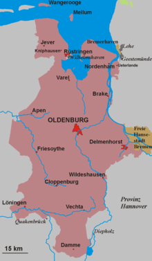
Oldenburg Land
Appearance
| Oldenburger Land | |
|---|---|
| Region, regional association, and district of the Grand Duchy of Oldenburg, the Free State of Oldenburg, and Oldenburg | |
 | |
| History | |
• Established | 1993 |
Oldenburg Land (
Boßeln
.
The mainly Catholic southern part of the Oldenburg Land is known as Oldenburg Münsterland, the mainly Lutheran northern part is known as Oldenburg Land (Old Oldenburg) in its narrower sense.
In terms of Germany's modern administrative
Wesermarsch, and Wilhelmshaven. These 9 districts have a combined population of about 1.1 million (per the end of 2016) and an area of about 5,700 km2 (2,200 mi2
).
The borders of the Oldenburg Land are still clear today from the boundaries of institutions such the Evangelical Lutheran Church in Oldenburg, the Offizialatsbezirk Vechta of the Roman Catholic Diocese of Münster and the Landessparkasse zu Oldenburg.
Towns and villages
The largest towns, apart from the former state and district capital of
Oldenburg with about 160,000 inhabitants are Wilhelmshaven (~ 83,000) and Delmenhorst
(~75,000). Other large towns include:
|
Sources
- Gerhard Wietek: Oldenburger Land (Deutsche Lande – Deutsche Kunst). 2. Auflage, München/Berlin 1974


