
Opir (river)
| Opir | |
|---|---|
 The Opir River near Hrebeniv, 2008 | |
| Native name | О́пір (Ukrainian) |
| Location | |
| Country | Ukraine |
| Oblast | Lviv Oblast |
| Physical characteristics | |
| Source | |
| • location | near Oporets[1] |
| • coordinates | 48°47′49.6″N 23°17′14.3″E / 48.797111°N 23.287306°E |
| • elevation | 975 m (3,199 ft) |
| Mouth | Stryi |
• location | near Verkhnie Synovydne[2] |
• coordinates | 49°06′45.0″N 23°35′40.9″E / 49.112500°N 23.594694°E |
• elevation | 370 m (1,210 ft) |
| Length | 58 km (36 mi)[3] |
| Basin size | 843 km2 (325 sq mi)[3] |
| Basin features | |
| Progression | Stryi→ Dniester→ Dniester Estuary→ Black Sea |
| Tributaries | |
| • left | |
| • right | |
The Opir River (Ukrainian: О́пір) is located in Ukraine, within Stryi Raion of Lviv Oblast. It is a right tributary of the river Stryi (Dniester basin).
Geography
The Opir River originates on the eastern slope of Velykyi Yavirnyk Mountain (
The Opir is 58 kilometres (36 mi) long, with a basin size of 843 km2 (325 sq mi).
Recently, the river has become popular among tourists who go rafting.[4]
Tributaries
Eight small rivers and 31 streams with a total length of 94.3 kilometres (58.6 mi) and an area of 21.9 hectares (54 acres) flow into the river.
- Right: Kamianka, Chudyliv, Pavliv, Hrebenovets, Zelemyanka, Tsihla, Rozhanka, Slavka, Khokhlinsky, Pysarivka, Oporets.
- Left: Zakuty, Lavochanka, Dubrivka, Oriava, Yakhystiv, Holovchanka, Rovina.
Settlements
Several settlements are located on the river (in order from the
Gallery
-
![Opir river valley (view from the Zelemyanka ridge [uk]).](//upload.wikimedia.org/wikipedia/commons/thumb/7/7b/Opir-2.JPG/120px-Opir-2.JPG) Opir river valley (view from the Zelemyanka ridge).
Opir river valley (view from the Zelemyanka ridge). -
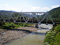 Railway bridge on the Opir.
 -
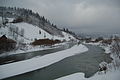 Opir in winter.
![Opir river valley (view from the Zelemyanka ridge [uk]).](/File:Opir-2.JPG)


References
- ^ .
- ISBN 9780231145541.
- ^ a b c d e Anna Hryhorivna Lutsyk, Pavlo Volodymyrovych Bosak (2019). "Антропогенне забруднення річок смт. Славське" [Anthropogenic pollution of rivers in the town of Slavske] (PDF). Проблеми та перспективи розвитку системи безпеки життєдіяльності (in Ukrainian): 163–165.
- ISSN 2617-2909.