
Padre Island National Seashore
| Padre Island National Seashore | |
|---|---|
IUCN category V (protected landscape/seascape) | |
 | |
  | |
| Location | Padre Island, Texas, United States |
| Nearest city | Corpus Christi, Texas |
| Coordinates | 26°59′04″N 97°22′50″W / 26.98444°N 97.38056°W |
| Area | 130,434 acres (527.85 km2) |
| Established | September 28, 1962 |
| Visitors | 650,000 (in 2015) |
| Governing body | National Park Service |
| Website | Padre Island National Seashore |

Padre Island National Seashore (PINS) is a
Most of the park is primitive, but camping is available, and most of the beach is only accessible to four-wheel-drive vehicles. All but four miles is open to vehicle traffic. PAIS is the fourth designated national seashore in the United States.[1]
Padre Island is the longest undeveloped barrier island in the world. The national seashore is 70 miles (110 km) long with 65.5 miles (105.4 km) of Gulf beach. PAIS hosts a variety of pristine beach, dune, and tidal flat environments,
Padre Island
Padre Island National Seashore is located on Padre Island, the largest of the
It is about 113 miles (182 km) long and 1.8 miles (3 km) wide,[4] Padre Island is the second-largest island by area in the contiguous United States, after Long Island in New York on the Atlantic Coast.[5]
Geology
The geology of Padre Island National Seashore doesn't just belong within the park itself. PAIS is part of the world's longest natural
General physiography
Geologically extremely young, Padre Island is a vastly dynamic geologic feature. Unlike most of today's geologic features, such as the Grand Canyon, Padre Island changes constantly. Situated in a stable depository basin, there isn't much that can intervene with the barrier bars, except for the occasional hurricanes that come by. Most of Padre Island is less than 20 feet above mean sea level. Constant bombardment of prevailing southeasterly winds from the Gulf of Mexico heap beach of sand into high foredunes. In some places, the onshore wind may blow loose sand from the foredunes and beach across the flats beyond. Active sand dunes march across the island, smothering vegetation in their paths and leaving barren sandflats in their wakes. In other places, vegetation may win a battle of its own and stabilize the blowing sand by binding it with roots and vines. Slower daily movements of the sand and stabilizing effects of vegetation are interrupted occasionally by the brutal force of hurricane winds, waves, and tides. During storms, beaches are eroded, vegetation is ripped up, dunes are flattened, and channels are scoured across the island.[7]
Laguna Madre
Laguna Madre, separating Padre Island from the Texas mainland, is locked in by the barrier island. Consequently, circulation of seawater in and out of the lagoon is highly restricted. The combination of a high rate of evaporation under the hot Texas sun and little mixing with either freshwater or normal seawater has made Laguna Madre extremely salty.
The maximum width of the lagoon is approximately 10 miles. In many places, however, lagoon width fluctuates considerably with the height of
Like the island environments, the environments of Laguna Madre vary considerably. Within the national seashore, the northern part of the lagoon is occupied largely by grassflats having an average water depth of about 3 feet. These grassflats are environments of very high biologic activity, serving as spawning grounds for a number of fish, clams, and snails.
The shallowest parts of the lagoon lie in the central part of the national seashore. These areas are known as Middle Ground and the Land-Cut Area, where the Intracoastal Waterway was dredged through the rarely flooded wind-tidal flats (pl. I). The Hole, which lies between Middle Ground and the Land-Cut Area, is not really much of a hole; its average depths are only 1 to 2 feet. This "hole" is occupied mostly by flats supporting shoalgrass and algae. The deepest parts of the lagoon are south of the Land-Cut Area, where the muddy sand bottoms lie at depths as great as 8 feet.
Two small natural islands in Laguna Madre are unique environments within the national seashore. North and South Bird Islands, each a series of sand berms or ridges, have become important bird rookeries. Some of the man-made spoil islands along the Intracoastal Waterway are also nesting grounds for a variety of birds.
-
 Sand dunes and wildflower at beach (Nov 2022)
 -
 Interior island grassland (Oct 2022)
 -
 Interior island dunes (Nov 2022)
 -
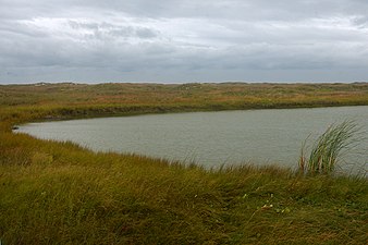 A freshwater pond (Nov 2022)


Biology
Kemp's ridley sea turtles
_(f1b41723-09a4-4933-8312-14fedb1c1b81).jpg)
A program to re-establish a nesting beach for
In September 2007,
Birdwatching
Due to the location of Padre Island National Seashore on the
The best time to see the multitude of the park's bird migrants is during either early spring or fall and winter, when thousands of birds spend the winter there or migrate through the area.
Bird Island Basin, on the
-
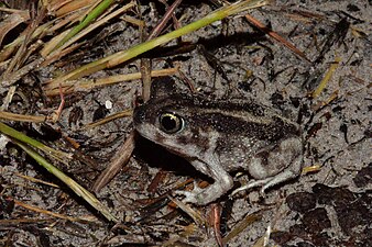 Hurter's Spadefoot Toad (Scaphiopus hurterii) Padre Island NS (Nov 2022)
 -
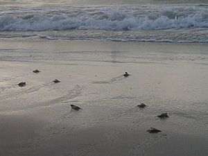 A public release ofKemp's ridley sea turtlehatchlings at Padre Island NS
 -
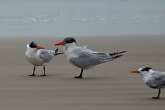 Caspian terns (Sterna caspia) left, royal tern (Sterna maxima) right, Padre Island NS (Nov 2022)
 -
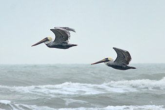 Brown Pelican (Pelecanus occidentalis), Padre Island NS (Nov 2022)
 -
 Coyote (Canis latrans), Padre Island NS (Oct 2009)


.jpg)
Shoreline trash

During periods throughout the summer months there may be a large amount of Oil and tar can commonly wash up onto the beaches as well, 94% of which originates from oil spills, engine lubrication oil, and tanker washings. The park relies on a "grass roots" policy that encourages park visitors to take out more trash than they bring in. Organization such as the Friends of Padre have removed over 2,000 tons of trash at their yearly Billy Sandifer Big Shell Beach Clean Up the last weekend of February every year.
A study by the park, started in 1994, to analyze the origin of debris, titled the PAIS Marine Debris Point Source Investigation. The park began collecting data in 1998 to catalogue and remove debris from 16 miles (26 km) of beach. Currently the park has collected over 1,000 days of data for the project, covering a collective area of over 16,800 miles (27,000 km) of shoreline surveyed. This study is one of the first long-term and comprehensive marine debris research projects started within the United States. From its result the vast majority of the debris is traced to the commercial shrimping industry while approximately 14% comes from the offshore oil and gas industry.[14]
Naturalist and fishing guide Billy Sandifer founded an annual beach cleanup at the park in 1996. The cleanup targets the Big Shell Beach portion of the island, around the 20-25 mile marker. In 2007, Sandifer established the Friends of Padre, a
Climate

| ||||||||||||||||||||||||||||||||||||||||||||||||||||||||||||||||||||||||||||||||||||||||||||||||||||||||||||||||||||||||||||
Oil and natural gas drilling
Oil and natural gas drilling is allowed within the park. Congress has not approved the purchase of the mineral rights within the park even though the boundaries were surveyed as early as 1957.
References
- ^ a b David Sikes of Corpus Christi Caller-Times, "Padre Island seashore marks 50th", Laredo Morning Times, December 3, 2012, p. 3A
- ^ "Geological Wonders". National Park Service website. Archived from the original on 2006-10-05. Retrieved 2006-06-25.
- ^ "Ballí, José Nicolás". Handbook of Texas Online. Texas State Historical Society. Retrieved 2015-08-15.
- .
- ^ * "Padre Island", Encyclopædia Britannica
- ^ "Texas Bureau of Economic Geology: Padre Island National Seashore: A Guide to the Geology, Natural Environments, and History of a Texas Barrier Island (Origin and Geologic History of Padre Island)". Archived from the original on 2007-08-30.
- ^ "Texas Bureau of Economic Geology: Padre Island National Seashore: A Guide to the Geology, Natural Environments, and History of a Texas Barrier Island (Introduction)". Archived from the original on 2007-09-03.
- ^ Yahoo.com, Endangered turtle nests found in Texas
- ^ Padre Island Administrative History, Addendum: Events Since 1994 Archived 2006-10-14 at the Wayback Machine, National Park Service, Retrieved February 1, 2015
- ^ a b c "Birdwatching". Padre Island National Seashore. National Park Service. Retrieved 2009-09-01.
- ^ "Padre Island National Seashore birds". National Park Service. Retrieved 2019-07-25.
- ^ "International Convention for the Prevention of Pollution from Ships, 1973, as modified by the Protocol of 1978 relating thereto (MARPOL)". Archived from the original on 2008-07-30. Retrieved 2008-07-30.
- ^ Handbook of Texas Online – GULF OF MEXICO
- ^ Padre Island National Seashore - Shoreline Trash (U.S. National Park Service)
- ^ "Friends of Padre". Friends of Padre Inc. Retrieved 2023-03-15.
- ^ "NASA Earth Observations Data Set Index". NASA. Retrieved 30 January 2016.
- ^ "The Oil and Gas Story - Padre Island National Seashore (U.S. National Park Service)".
External links
- National Park Service: Padre Island National Seashore
- National Park Service: Sea Turtle Science and Recovery at PAIS
- National Park Service: Padre Island National Seashore, Birdwatching
- GORP's Padre Island National Seashore Guide
- National Park Service: Padre Island National Seashore, Facebook
- The White Island, 1963 television documentary previews Padre Island National Seashore for future visitors, Texas Archive of the Moving Image