
Plymouth Breakwater
50°20′2.98″N 4°8′55.18″W / 50.3341611°N 4.1486611°W
 | |
 | |
| Location | Plymouth Breakwater, City of Plymouth, United Kingdom |
|---|---|
| Coordinates | 50°20′05″N 4°09′32″W / 50.3346°N 4.1588°W |
| Tower | |
| Constructed | 1841 |
| Construction | Stone Tower |
| Height | 23 m (75 ft) |
| Shape | Cylindrical tower with balcony and lantern[1] |
| Markings | White tower and lantern |
| Operator | Ministry of Defence (1993–), Trinity House (–1993) |
| Fog signal | Blast every 15s. |
| Light | |
| First lit | 1844 |
| Focal height | 19 m (62 ft) |
| Lens | 2nd order fixed catadioptric |
| Range | 12 nmi (22 km; 14 mi) (white), 9 nmi (17 km; 10 mi) (red) |
| Characteristic | Fl WR 10s. Iso W 4s. at 12 metres (39 ft) |
Plymouth Breakwater is a 1,560-metre (1,710 yd) stone breakwater protecting Plymouth Sound and the anchorages near Plymouth, Devon, England. It is 13 metres (43 ft) wide at the top and the base is 65 metres (213 ft). It lies in about 10 metres (33 ft) of water. Around 4 million tons of rock were used in its construction in 1812 at the then-colossal cost of £1.5 million (equivalent to £106 million today).
History
In 1806, as the
The foundation stone was laid on Shovel Rock on 8 August 1812. It followed a line over Panther Rock, Shovel and St. Carlos Rocks, and was sufficiently completed by 1814 to shelter ships of the line. Napoleon was reported as commenting that the breakwater was a grand thing, as he passed by it on the way to exile on St. Helena in 1815. Severe storm damage in 1817 and 1824 prompted a change in the profile and height. John Rennie died in 1821; his last work in connection with the breakwater was to draw up proposals for a lighthouse.
Plymouth Breakwater Lighthouse
Plymouth Breakwater Lighthouse stands on the western tip of the breakwater. Designed for the Admiralty by Walker & Burgess, construction of the granite tower began on 22 February 1841 and was completed on 9 November 1843; William Stuart was superintendent of the works.[5] The light became operational in June 1844; soon afterwards a horse-drawn omnibus was driven along the breakwater from end to end, with a full complement of passengers accompanied by a military band.[6] On completion, management of the light was transferred to Trinity House.[5]
A beacon was placed at the eastern end of the breakwater, consisting of a 6-foot (1.8 m) spherical cage on a 17-foot (5.2 m) pole; the cage was designed as a refuge for six shipwrecked sailors.[7]
The lighthouse had been provided with a
By 1867 a 7 cwt bell had been installed at the lighthouse to serve as a fog signal. In 1879 a larger (32 cwt) bell was installed, and the old bell was transferred to
In 1920 the lighthouse was converted to run automatically on acetylene gas. Following departure of the resident keepers, the light was monitored from the Trinity House fog signal station at nearby Penlee Point.
Oversight of the lighthouse was passed from Trinity House to the Ministry of Defence in 1993. The bell remained in use until 1994, when it was replaced by an electronic fog horn. The main light currently flashes once every ten seconds, white with a red sector to the north-east; the subsidiary white light has an
Plymouth Breakwater Fort

In 1860, a
Gallery
-
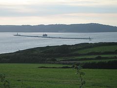 Plymouth breakwater from Wembury
 -
 Plymouth breakwater from Kingsand showing the 1844 lighthouse and the Breakwater Fort beyond
 -
 Plymouth breakwater, viewed from above Kingsand
 -
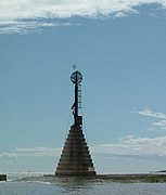 Plymouth breakwater: the eastern beacon


See also
- National Harbor of Refuge, a comparable structure at the mouth of Delaware Bay in the United States, intended principally for civilian use.
- List of lighthouses in England
References
- ^ Rowlett, Russ. "Lighthouses of Southwest England (Devon and Cornwall)". The Lighthouse Directory. University of North Carolina at Chapel Hill. Retrieved 4 May 2016.
- ^ Lodge, Edmund (1840). Genealogy of the Existing British Peerage: With Sketches of the Family Histories of the Nobility. London: Saunders. p. 354. Retrieved 25 July 2021.
- JSTOR 107609.
- ^ "Memoirs". Minutes of Proceedings of the Institution of Civil Engineers. XIV: 140. 1855.
- ^ a b c d "Lighthouse management : the report of the Royal Commissioners on Lights, Buoys, and Beacons, 1861, examined and refuted Vol. 2". 1861. pp. 87–88.
- ^ Plymouth Times, 27 July 1844
- ^ Moseley, Brian (26 February 2013). "[Plymouth] Breakwater". The Encyclopaedia of Plymouth History. Archived from the original on 17 May 2013. Retrieved 12 February 2015.
- ^ Elliot, George H. (1875). European Light-House Systems. London: Lockwood & co. pp. 137–139. Archived from the original on 29 October 2020. Retrieved 10 March 2019.
- ^ Edwards, E. Price (1884). Our Seamarks: a plain account of the Lighthouses, Lightships, Beacons, Buoys, and Fog-signals maintained on our Coasts. London: Longmans, Green & co. p. 184. Retrieved 25 February 2019.
- ^ Renton, Alan (2001). Lost Sounds: The Story of Coast Fog Signals. Caithness, Scotland: Whittles.
- ^ London Gazette, Issue 24871, Page 4322, 6 August 1880
- ^ "Plymouth Sound and Approaches". GPS Nautical Charts. Retrieved 18 March 2019.
- ^ "The Breakwater Fort, Plymouth - the Palmerston battery at the mouth of the Sound". BBC. Retrieved 22 October 2011.
External links
| Authority control databases: Plymouth Breakwater Lighthouse |
|
|---|