
Point Pelee National Park
| Point Pelee National Park | |
|---|---|
 Boardwalk in April | |
 Location of Point Pelee National Park in Canada | |
| Location | Ontario, Canada |
| Nearest city | Leamington, Ontario |
| Coordinates | 41°57′51″N 82°31′4″W / 41.96417°N 82.51778°W |
| Area | 15 km2 (5.8 sq mi) |
| Established | 29 May 1918 |
| Governing body | Parks Canada |
| Official name | Point Pelee |
| Designated | 27 May 1987 |
| Reference no. | 368[1] |
Point Pelee National Park (
History
Aboriginal people lived on Point Pelee for many years before European colonization, dating back to at least 6,000 years.[2] The largest archaeological site found at Point Pelee is thought to have been occupied between AD 700 and 900.[4]
The name was given to the area by Fathers Dollier and Galinée when they passed through the area in 1670.[5]
In the late 1700s, British naval reserves logged the area's white pine for shipbuilding.[6] In 1790, Deputy Indian Agent Alexander McKee negotiated a treaty with Aboriginal communities that ceded a large tract of land, which included Point Pelee, to the Crown.[7] The Caldwell First Nation Chippewa people, who inhabited Point Pelee, were not signatories of that treaty. However, the Crown did not realize this, and their land was ceded nonetheless. Subsequently, they were forced off their land, and Point Pelee remains unceded aboriginal land. This has been publicly acknowledged by the Department of Indian and Northern Affairs Canada.[8]
Prior to the creation of the park, the Great Lakes Ornithological Club was established to study bird migration. One of the members, Percy A. Taverner, and Canada's first Dominion Ornithologist, recommended Point Pelee be made a national park in 1915. Jack Miner had also pushed for the creation of the park by that time.[9] Point Pelee was made a national park in 1918 at the urging of birdwatchers and hunters. Commercial fishing continued in the park until 1969. Point Pelee was the only Canadian national park to allow hunting until duck hunting was ended in 1989. This site was named "Pointe-Pelée" (meaning "bald point") by French explorers because the eastern side was rocky and had no trees.[10]
Point Pelee was designated a dark-sky preserve in 2006, the first Canadian national park to be designated as such.[11] In March 2006, high winds caused waves that washed away the sand point and all that remained was a platform.[12] In October 2007 the level of Lake Erie dropped enough to reveal the point again extending at least a kilometre out into the water and at least 7 metres (23 ft) wide with a winding curve shape to it.[13] Since that time the sandy tip continues to shift, grow longer or shorter, or even detach temporarily, from year to year.
Geography

Located in the western parts of the
Flora and fauna

Owing to its southernly location and the moderating effects of Lake Erie, the climate in the park is slightly warmer than the rest of Canada
Climate
Point Pelee has a humid continental climate (Dfa under the Köppen climate classification) with warm, humid summers, and cold winters that is modified by the surrounding waters of Lake Erie.[3] It lies in a zone that is characterized by variable weather due to conflict between polar and tropical air masses.[19] Its position in Lake Erie modifies its climate, resulting in warmer winter and fall temperatures compared to inland regions, as the lake cools more slowly than the surrounding land though during the spring, temperatures remain cooler than inland areas due to the land warming faster than the lake.[19]
Winters are cold with a January average temperature of −3.9 °C (25.0 °F). Owing to its position in Lake Erie, winter temperatures are warmer than inland locations at a similar latitude due to the release of the heat stored by the lake.[19][20] As a result, temperatures below −20 °C (−4.0 °F) are rare, with only 1.9 days where the temperature reaches or falls below −20 °C (−4.0 °F).[21] The maximum temperature usually stays below freezing on most days although mild spells of weather can occur time to time. The park receives 98.9 centimetres (38.9 in) of snowfall per year and there are 30.6 days with measurable snow.[21] The park is not located in the snowbelt region, and snow cover is intermittent through the winter.
Summers are warm and humid with the warmest month, July, averaging 22.4 °C (72.3 °F), which is among the highest in Ontario.[19] The surrounding lake moderates summertime temperatures, cooling the flow of warm air masses originating from the Gulf of Mexico and as a result, temperatures above 30 °C (86.0 °F) are rare, with only 4–8 days per year in the park.[20][21]
| Climate data for Point Pelee National Park | |||||||||||||
|---|---|---|---|---|---|---|---|---|---|---|---|---|---|
| Month | Jan | Feb | Mar | Apr | May | Jun | Jul | Aug | Sep | Oct | Nov | Dec | Year |
| Record high °C (°F) | 13.0 (55.4) |
14.5 (58.1) |
22.5 (72.5) |
28.5 (83.3) |
31.5 (88.7) |
33.5 (92.3) |
34.0 (93.2) |
34.5 (94.1) |
31.0 (87.8) |
25.5 (77.9) |
20.6 (69.1) |
18.5 (65.3) |
34.5 (94.1) |
| Mean daily maximum °C (°F) | −0.8 (30.6) |
0.3 (32.5) |
5.0 (41.0) |
11.6 (52.9) |
18.1 (64.6) |
23.6 (74.5) |
26.8 (80.2) |
25.7 (78.3) |
21.6 (70.9) |
15.0 (59.0) |
8.3 (46.9) |
1.9 (35.4) |
13.1 (55.6) |
| Daily mean °C (°F) | −3.9 (25.0) |
−3 (27) |
1.4 (34.5) |
7.4 (45.3) |
13.7 (56.7) |
19.4 (66.9) |
22.4 (72.3) |
21.5 (70.7) |
17.6 (63.7) |
11.4 (52.5) |
5.5 (41.9) |
−0.7 (30.7) |
9.4 (48.9) |
| Mean daily minimum °C (°F) | −6.9 (19.6) |
−6.2 (20.8) |
−2.2 (28.0) |
3.1 (37.6) |
9.3 (48.7) |
15.1 (59.2) |
18.0 (64.4) |
17.2 (63.0) |
13.6 (56.5) |
7.8 (46.0) |
2.6 (36.7) |
−3.3 (26.1) |
5.7 (42.3) |
| Record low °C (°F) | −27.0 (−16.6) |
−24.0 (−11.2) |
−18.0 (−0.4) |
−9.8 (14.4) |
−3.2 (26.2) |
3.0 (37.4) |
7.0 (44.6) |
4.0 (39.2) |
−1.7 (28.9) |
−5.5 (22.1) |
−9.4 (15.1) |
−23.0 (−9.4) |
−27.0 (−16.6) |
| Average precipitation mm (inches) | 57.2 (2.25) |
58.7 (2.31) |
69.9 (2.75) |
75.6 (2.98) |
76.9 (3.03) |
79.8 (3.14) |
83.6 (3.29) |
85.9 (3.38) |
92.7 (3.65) |
69.6 (2.74) |
94.8 (3.73) |
77.4 (3.05) |
922.1 (36.30) |
| Average rainfall mm (inches) | 27.9 (1.10) |
31.3 (1.23) |
51.7 (2.04) |
71.7 (2.82) |
76.9 (3.03) |
79.8 (3.14) |
83.6 (3.29) |
85.9 (3.38) |
92.7 (3.65) |
69.6 (2.74) |
90.9 (3.58) |
56.8 (2.24) |
818.8 (32.24) |
| Average snowfall cm (inches) | 30.5 (12.0) |
27.3 (10.7) |
18.4 (7.2) |
3.8 (1.5) |
0.0 (0.0) |
0.0 (0.0) |
0.0 (0.0) |
0.0 (0.0) |
0.0 (0.0) |
0.06 (0.02) |
3.6 (1.4) |
20.0 (7.9) |
103.8 (40.9) |
| Average precipitation days (≥ 0.2 mm) | 13.4 | 11.4 | 12.8 | 14.7 | 13.3 | 11.7 | 10.9 | 10.1 | 11.7 | 13.5 | 15.3 | 15.4 | 154.4 |
| Average rainy days (≥ 0.2 mm) | 4.7 | 4.9 | 9.0 | 14.0 | 13.3 | 11.7 | 10.9 | 10.1 | 11.7 | 13.5 | 14.2 | 8.9 | 127.1 |
| Average snowy days (≥ 0.2 cm) | 9.2 | 7.1 | 4.7 | 1.3 | 0.0 | 0.0 | 0.0 | 0.0 | 0.0 | 0.15 | 1.7 | 7.5 | 31.6 |
| Source: Environment Canada[21]
| |||||||||||||
Human impact
Development
From a regional perspective, the park is isolated from other natural areas because in Essex County, less than 6% of the native forest cover and 3% of the wetlands remain intact.
Birdwatching
The park forms the southernmost point in mainland Canada (its latitude is the same as that of Rome, Italy and Barcelona, Spain)[22] and is part of a bird and butterfly migration corridor over Lake Erie via Point Pelee and the Lake Erie islands.[23] Over 360 bird species have been recorded in the park. The peak time for bird migration is spring, especially May, when tired migrants make first landfall after their journey north across the lake.[24]
Many birdwatchers from North America and abroad visit the park in May,[6] often staying in the nearby town of Leamington.[25] One attraction, apart from the sheer numbers and variety of birds passing through on migration, is the opportunity to see more northerly breeding species before they move on.[22] It is widely recognized as one of the most desirable destinations for avid birdwatchers, particularly for the migration of Passerines.[26]
Occurrences
March 2017 marsh fire
On 29 March 2017, Point Pelee's marsh land was involved in a fire that burned over 125 hectares (310 acres) of marsh habitat. The fire lasted 15 hours and was naturally extinguished due to rainfall the following day.[27]
Commemoration
Point Pelee National Park was featured on a high-value ($5) postage stamp, issued in 1983, as part of a series honouring national parks. The park appeared on a stamp that was issued on 15 January 2018, with a $1.20 face value. The issue coincides with the park's centennial year, and is part of a nine-stamp set featuring scenic views across the country.[28]
Images
-
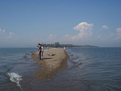 Point Pelee tip looking North, 2007
 -
 Point Pelee tip looking South, 2007
 -
 Point Pelee looking South, Apr 2008
 -
 Point Pelee looking Southwest, Jan 2015
 -
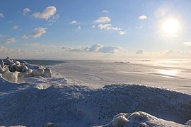 Point Pelee looking Southeast, Jan 2018
 -
 Pelee looking South, Jan 2018
 -
 Boardwalk across a marsh in the park
 -
 Boardwalk, August
 -
 Boardwalk, January
 -
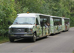 One of Point Pelee's shuttles


See also
- National Parks of Canada
- List of National Parks of Canada
- Long Point, Ontario
References
- ^ "Point Pelee". Ramsar Sites Information Service. Retrieved 25 April 2018.
- ^ ISBN 9781100157566. Archived(PDF) from the original on 12 April 2013. Retrieved 13 April 2013.
- ^ a b c d e f g h i j k "Point Pelee National Park, Ontario - Information Sheet on Ramsar Wetlands" (PDF). Ramsar Sites Information Services. Archived from the original (PDF) on 29 April 2018. Retrieved 12 April 2013.
- ^ Man's Impact on Point Pelee National Park, Ottawa: National Provincial Parks Association, 1978, pp. 44, 53
- ISBN 1-55263-569-4.
- ^ ISBN 978-1-4262-1756-2.
- ^ "Treaty No. 2." (1992). Indian Treaties and Surrenders. Saskatoon: Fifth House Publishers.
- ^ Leclair, Laurie (1988), The Caldwell People of Point Pelee and Pelee Island: A Brief History and Survey of Documents, Department of Indian Affairs and Northern Development
- ^ Hill, Sharon (29 May 2018). "Playground or protection? 100-year-old Point Pelee National Park finds a balance". Windsor Star. Retrieved 31 December 2018.
- ^ a b c d e f "Point Pelee National Park". The Canadian Encyclopedia. Archived from the original on 17 November 2013. Retrieved 12 April 2013.
- ^ Hill, Sharon (23 March 2018). "Dark park: Point Pelee's dark sky preserve wows stargazers". Windsor Star. Retrieved 28 January 2019.
- ^ "High winds leave Point Pelee pointless". CBC News. 16 March 2006. Retrieved 31 March 2007.
- Canada.com.
- ^ a b c d e f g "An Overview of Environment Canada's Groundwater Research Activities at Point Pelee National Park, Ontario" (PDF). Parks and Protected Areas Research in Ontario. 1998. pp. 225–238. Archived from the original (PDF) on 4 March 2016. Retrieved 13 April 2013.
- ^ "Soil Survey of Essex County" (PDF). Dominion Department of Agriculture and The Ontario Agricultural College. 1949. p. 54. Archived from the original (PDF) on 1 June 2013. Retrieved 26 November 2018.
- ISBN 978-1847731098.
- ^ Dhaliwal, Arvind. "Point Pelee National Park - Animals". Retrieved 26 November 2018.
- ISBN 978-1-4262-1756-2.
- ^ a b c d "Point Pelee National Park of Canada: Weather". Parks Canada. August 2009. Retrieved 24 May 2013.
- ^ a b "Natural Processes in the Great Lakes". The Great Lakes An Environmental Atlas and Resource Book. U.S Environmental Protection Agency. Retrieved 24 May 2013.
- ^ a b c d "Point Pelee, Ontario". Canadian Climate Normals 1981–2010. Environment Canada. Retrieved 6 September 2013.
- ^ a b Sinanan, Josiah (22 May 2022). "A birdwatchers delight at Point Pelee as European travellers flock for May migration". CBC News. Retrieved 14 August 2022.
- ^ "Thousands of monarch butterflies flock to Point Pelee en-route to Mexico". CBC News. 12 September 2018. Retrieved 14 August 2022.
- ISBN 0-8020-6802-2.
- ^ "Point Pelee's Festival of Birds takes flight after 2-year absence". CBC News. 3 May 2022. Retrieved 14 August 2022.
- ISSN 0091-7648.
- ^ "125 hectares of marsh land destroyed by fire at Point Pelee National Park". Windsor Star. 30 March 2017. Retrieved 30 March 2017.
- ^ "Lincoln Alexander, Emergency Responders, and Women in Winter Sports among new stamps to be issued in 2018" (Press release). Canada Post. 13 November 2017. Retrieved 15 January 2020.