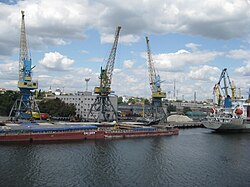
Port of Kherson
| Port of Kherson | |
|---|---|
 | |
 Click on the map for a fullscreen view | |
| Location | |
| Country | |
| Location | Kherson, Kherson Oblast |
| Coordinates | 46°37′27″N 32°36′20″E / 46.6242°N 32.6056°E |
| Details | |
| Opened | 1778 |
| Owned by | Ukrainian Sea Ports Authority (government) |
| Type of harbour | Natural/Artificial |
| No. of berths | 10 |
| Chief | Anatoliy Yablunovskyi |
| Statistics | |
| Website www.uspa.gov.ua/khe/ | |
Port of Kherson (Ukrainian: Херсонський морський порт, Khersonsky morsky port) is a port in the city of Kherson, Ukraine. It is located in the delta of Dnieper river.
The berthing line of the seaport is 1.5 km (10 berths), with depths up to 9.6 m. The port is served by the railway station Kherson-Port, has one railway entry. There are 7 railway tracks in the port area with a total length of 3.2 km. The highways are adjacent to the port.
The cargo turnover of Kherson seaport in 2016 amounted to 3.7 million tons. The capacity of terminals of Kherson seaport reaches 8.0 million tons / year.
See also
References
- ^ ""Kherson river port" DP JSSC "Ukrrichflot"". graintrade.com.ua. Retrieved April 30, 2022.
External links
