
Portreath
Portreath
| |
|---|---|
 Portreath harbour at low tide | |
 Portreath Location within Cornwall | |
| Population | 1,336 (2011 census including Bridge and Cambrose)[1] |
| OS grid reference | SW655455 |
| Unitary authority | |
| Ceremonial county | |
| Region | |
| Country | England |
| Sovereign state | United Kingdom |
| Post town | REDRUTH |
| Postcode district | TR16 |
| Dialling code | 01209 |
| Police | Devon and Cornwall |
| Fire | Cornwall |
| Ambulance | South Western |
| UK Parliament | |
Portreath (
Portreath lies within the
History
The name Portreath (meaning "sandy cove") was first recorded in 1485, and
In the late 1770s, during the
By 1827, Portreath was described as
With the population growing, a church was built in 1827; the Portreath Hotel (1856), Methodist Chapel (1858), Basset Arms (1878) and the School (1880) all followed.
Tramroads and railways
The Portreath Tramroad, the first railway in Cornwall, was started in 1809 to link the harbour with the copper mines at Scorrier and St Day. By 1812 the tramroad reached Scorrier House, one of the financiers' houses, and was completed by 1819. It was horse-drawn with wagons on an approximately 4 ft (1.2 m) gauge using L-shaped cast iron plates on square granite blocks. The line was little-used after the Poldice mine closed in the 1860s, and the tramroad was closed in 1865.[13]
The Portreath branch of the
The railways and Portreath Tramroad associated with the minerals trade today form the Mineral Tramways Coast to Coast, a long-distance cycleway and footpath extending 15 miles (24 km) from Portreath to the south coast.[10][15]
Nancekuke
Cornish wrestling
There were Cornish wrestling tournaments, for prizes, held at the Basset Arms[16] during the 1800s.[17][18]
Nance Wood
Nance Wood, 1 mile (1.6 km) to the south east of the village, is a narrow strip of semi-natural woodland on a steep north-facing slope which was designated as a Site of Special Scientific Interest for its biological characteristics.
Most of the woodland is a 4–6 metres (13–20 ft) high, wind-pruned, sessile oak (Quercus petraea) last coppiced in the first half of the 20th century. The woods are one of only two sites in Britain to contain Irish spurge (Euphorbia hyberna), which is listed in the Red Data Book of rare and endangered plant species.[19][20]
Gallery
-
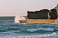
 The beach and Gull Rock at sunset
 -
 Portreath harbour mole
 -
 Portreath inner harbour


References
- ^ "Parish population 2011". Retrieved 8 April 2015.
- ^ Place-names in the Standard Written Form (SWF) Archived 15 May 2013 at the Wayback Machine : List of place-names agreed by the MAGA Signage Panel Archived 15 May 2013 at the Wayback Machine. Cornish Language Partnership.
- ISBN 978-0-319-23148-7
- ^ "Bassetts Cove (Spratting Cove)". Cornwall Beach Guide. Retrieved 31 July 2018.
- ^ "Portreath school children encouraged to help Portreath go hedgehog friendly - Cornwall Council". Archived from the original on 23 April 2017. Retrieved 22 April 2017.
- ^ "The hedgehog friendly village". BBC News.
- ^ a b "Cornwall Industrial Settlements Initiative – Portreath" (PDF). Cornwall County Council, Historic Environment Service. March 2002. Retrieved 2 July 2009.
- ^ "Cornwall Online's Portreath pages". Cornwall Online. Archived from the original on 13 December 2009. Retrieved 2 July 2009.
- ^ a b c d "Harbour History". Portreath Harbour Association. Retrieved 22 April 2014.
- ^ ISBN 978-1-84114-753-6.
- ^ a b "About Portreath". Archived from the original on 28 January 2012. Retrieved 1 September 2012.
- ^ "Launch at Portreath". The Cornishman. No. 308. 12 June 1884. p. 6.
- ^ Historic England. "Poldice Tramroad (426063)". Research records (formerly PastScape). Retrieved 22 April 2014.
- ^ a b Historic England. "Hayle Railway (Portreath Branch) (426145)". Research records (formerly PastScape). Retrieved 22 April 2014.
- ^ Sustrans website Retrieved May 2010
- ^ Royal Cornwall Gazette, 19 July 1878.
- ^ Royal Cornwall Gazette, 9 July 1808.
- ^ West Briton and Cornwall Advertiser, 4 September 1857.
- ^ "Nance Woods SSSI". Natural England. Retrieved 2 April 2020.
- ^ "Nance Wood" (PDF). Natural England. 1984. Archived from the original (PDF) on 24 October 2012. Retrieved 3 November 2011.
External links
| Unitary authorities | |
|---|---|
| Major settlements (cities in italics) |
|
| Rivers | |
| Topics | |