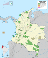
Puinawai Natural Reserve
| Puinawai Natural Reserve | |
|---|---|
| Location | Guainía, Colombia |
| Nearest city | Inírida |
| Coordinates | 2°19′47″N 69°00′39″W / 2.329833°N 69.010792°W[1] |
| Area | 10,925 square kilometres (4,218 sq mi) |
| Established | 1989 |
Puinawai Natural Reserve (
Orinoco River basin, the Inírida River.[3]
The Natural Reserve lies between altitude of 200 to 380 metres (660 to 1,250 ft) above sea level and its climate is hot and humid with little seasonal variations throughout the year.
Ecosystem
The area of the Puinawai Natural Reserve mainly consists of humid tropical rainforest. However, there are also tropical open savanna and transitional zones.[4] Pressure from deforestation has so far remained relatively small, due to its inaccessibility and low population density. According to Colombia's national park services, 1% of Puinawai has been deforested.[5]
There are 419 endemic plant species in the natural reserve, 176 of which are
Guyana Shield. The reserve is also rich in fauna with many local species that were preserved also due to the local indigenous tribes practicing a sustainable co-existence with the local environment. The Puinawai Natural Reserve is not open to the public.[6]
References
- ^ "ProtectedPlanet - Puinawai Natural National Reserve". Archived from the original on 2013-03-31. Retrieved 2012-08-22.
- ^ "Reserva Nacional Natural Puinawai". Parques Nacionales Naturales de Colombia. Retrieved 9 April 2016.
- ^ "Reserva Nacional Natural Puinawai". Parques Nacionales Naturales de Colombia. Retrieved 9 April 2016.
- ^ "Reserva Nacional Natural Puinawai". Parques Nacionales Naturales de Colombia. Retrieved 9 April 2016.
- ^ "Amazonía posible y sostenible" (PDF). CEPAL. Retrieved 9 April 2016.
- ^ Estado del Parque: Cerrado al público


