
Rancho Santa Anita
| Rancho Santa Anita | |
|---|---|
| Land grant of Mexico | |
| 1845–1875 | |
| • Type | Mexican land grant |
| History | |
• Established | 1845 |
• Disestablished | 1875 |
| Today part of | United States |
Rancho Santa Anita was a 13,319-acre (53.90 km2)
History
The land granted to Reid was previously owned by the
Reid was a
With the
Joseph Andrew Rowe lived in the rancho for several years after purchasing it in 1854 for $33,000.[9] In 1858, Albert Dibblee (1816–1895) and William Corbett bought the rancho and who held it until 1864. Then 1865, 11,319 acres of Rancho Santa Anita, sold or $20,000 to William Wolfskills. William's son, Luis Wolfskill, sold 8,500 acres with the lake to Los Angeles merchant Harris Newmark for $85,000.
In 1869, Alfred Beck Chapman (born 1829, died 1915) bought 1,786 acres of Rancho Santa Anita, and built a home near modern California Boulevard and Ivydale Court, Chapman Woods. Chapman Woods Road is in Pasadena. Citrus, walnuts, avocados, and pecans still live where he planted them. Chapman also grew peas, lentils, and wheat. Chapman Avenue, and Chapman University were named after the West Point graduate who owned part of the Silverado Mine in Orange County. In the 1920s, Jim Stewart and Ben Quigley subdivided Chapman Woods.
In 1875, Newmark sold Rancho Santa Anita to Elias Jackson ("Lucky") Baldwin for $200,000. Lucky moved into the Hugo Reid's adobe house by the natural lake. In 1881 he built a white Queen Anne style house at the lake also a Queen Anne style coach barn for his prized horse.[10] Lucky loved horses, he initially founded a racetrack on Rancho Santa Anita in 1904. The racetrack closed in 1909 and burned down in 1912. In 1934, the current Santa Anita Park opened as a thoroughbred horse-racing track.[4][11] In the latter 1880s, Baldwin subdivided a portion of the rancho to establish the town of Arcadia. In February 1881, Nathaniel Carter (Jan. 24, 1840 – Sept. 2, 1904) purchased 845 acres of Rancho Santa Anita, along with two other purchases, to form the new town of Sierra Madre, California.[12][13]
In 1875, Lucky's Los Angeles Investment Company began subdividing and selling parcels from many of his ranchos. In 1883, 240 acres (970,000 m2) of Rancho Santa Anita were sold to
Historic sites of the Rancho
- Hugo Reid Adobe. Rancho Santa Anita adobe house built by Reid in 1839.[15]
- Santa Anita Depot, built in 1890 for the Santa Fe Railway.[16][17]
Gallery
-
 The home of Elias J. ("Lucky") Baldwin, the former Hugo Reid Adobe, at Rancho Santa Anita, ca.1903
 -
 Hugo Reid at Rancho Santa Anita.
 -
 Lucky Baldwin in 1905
 -
 Lucky Baldwin statue, Arcadia, California – across Huntington Avenue from Santa Anita Racetrack at Holly Avenue
 -
 Art deco entrance to Santa Anita's grandstands
 -
 Santa Anita Park track
 -

-
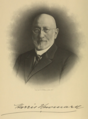 Harris Newmark
_Baldwin,_the_former_Hugo_Reid_Adobe,_at_Rancho_Santa_Anita,_ca.1903_(CHS-5178).jpg)


.jpg)


See also
- Santa Anita Park
- Los Angeles County Arboretum and Botanic Garden
- Ranchos of California
- List of Ranchos of California
References
- ^ Ogden Hoffman, 1862, Reports of Land Cases Determined in the United States District Court for the Northern District of California, Numa Hubert, San Francisco
- ^ Map of old Spanish and Mexican ranchos in Los Angeles County
- ^ Map of Rancho Santa Anita, ca.1800
- ^ a b Our History
- ^ Hugo Reid Adobe
- ^ United States. District Court (California : Southern District) Land Case 86 SD
- ^ Finding Aid to the Documents Pertaining to the Adjudication of Private Land Claims in California, circa 1852-1892
- ^ Report of the Surveyor General 1844 - 1886 Archived 2009-05-04 at the Wayback Machine
- ^ "Guide to the Joseph Andrew Rowe Papers, 1857-1861". California State Library. Retrieved 29 January 2012.
- ^ arboretum.org History
- ^ Arcadia - Yesterday and Today
- ^ ancestry.com, Los Angeles County, CA, Biographies, NATHANIEL C. CARTER
- ^ Annual Publication of the Historical Society of Southern California, Volume 6, Page 178, In memory of Nathaniel Coburn Carter
- ^ cityofmonrovia.org, History Monrovia
- ^ Hugo Reid Adobe at Rancho Santa Anita, ca.1900
- ^ "Early California History" (PDF). Los Angeles County Arboretum & Botanic Garden. Archived from the original (PDF) on 2010-12-24. Retrieved 2009-09-09.
- ^ "Caminos – Newsletter of the Arcadia Historical Society" (PDF). Arcadia Historical society. July 2007. Archived from the original (PDF) on 2011-06-08. Retrieved 2009-09-09.