
Randolph, Vermont
Randolph, Vermont | ||
|---|---|---|
Town | ||
FIPS code 50-58075[1] | | |
| GNIS feature ID | 1462182[2] | |
| Website | randolphvt | |
Randolph is a town in Orange County, Vermont, United States. The population was 4,774 at the 2020 census,[3] making Randolph the largest town in Orange County. The town is a commercial center for many of the smaller, rural farming communities that surround it.
When the area was originally settled there were three villages—Randolph Center, East Randolph and West Randolph—the current locations of the three fire departments.[4] What is now Randolph, the primary village of the town, had previously been the village of West Randolph.
History
Vermont granted the town on November 2, 1780, when the New Hampshire settlers could not locate the original grantees, whose patents were issued by New York. It was chartered on June 29, 1781 to Aaron Storrs and 70 others, and was originally named "Middlesex".[5]
The town was first settled c. 1778, when Vermont was an unrecognized state whose government existed in defiance of the government of New York, which claimed Vermont was a part of New York. To encourage recognition of the state by the United States, the town was renamed in honor of Edmund Randolph.[5]
With productive soil for
Two branches of the
In 1921, Randolph was the setting for, and provided some of the cast of, a
Today, Randolph is a thriving meeting-spot and shopping center for the surrounding area. The town is home to attractions such as the Porter Music Box Museum and the Chandler Music Hall. Also located in Randolph are the Gifford Medical Center, a hospital; Dubois & King, a civil and structural engineering firm; and Randolph Union High School, which also serves students from the neighboring towns of Braintree and Brookfield. Downtown Randolph hosts the Amtrak station, shops, restaurants, Playhouse Movie Theatre, and several gas stations.
-
 Union Block in 1912
 -
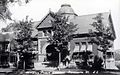 Kimball Library c. 1915
 -
 North Main Street in 1913


Geography
According to the United States Census Bureau, the town has a total area of 47.9 square miles (124.1 km2), of which 47.9 square miles (124.0 km2) is land and 0.04 square mile (0.1 km2) (0.08%) is water. Randolph is drained by the second and third branches of the White River.
Demographics
| Census | Pop. | Note | %± |
|---|---|---|---|
| 1790 | 893 | — | |
| 1800 | 1,841 | 106.2% | |
| 1810 | 2,255 | 22.5% | |
| 1820 | 2,487 | 10.3% | |
| 1830 | 2,743 | 10.3% | |
| 1840 | 2,678 | −2.4% | |
| 1850 | 2,666 | −0.4% | |
| 1860 | 2,502 | −6.2% | |
| 1870 | 2,829 | 13.1% | |
| 1880 | 2,910 | 2.9% | |
| 1890 | 3,232 | 11.1% | |
| 1900 | 3,141 | −2.8% | |
| 1910 | 3,191 | 1.6% | |
| 1920 | 3,010 | −5.7% | |
| 1930 | 3,166 | 5.2% | |
| 1940 | 3,278 | 3.5% | |
| 1950 | 3,499 | 6.7% | |
| 1960 | 3,414 | −2.4% | |
| 1970 | 3,882 | 13.7% | |
| 1980 | 4,689 | 20.8% | |
| 1990 | 4,764 | 1.6% | |
| 2000 | 4,853 | 1.9% | |
| 2010 | 4,778 | −1.5% | |
| 2020 | 4,774 | −0.1% | |
| [9] | |||
As of the
There were 1,769 households, out of which 31.5% had children under the age of 18 living with them, 50.9% were couples living together and joined in either
In the town, the population was spread out, with 23.3% under the age of 18, 15.9% from 18 to 24, 23.8% from 25 to 44, 23.1% from 45 to 64, and 13.9% who were 65 years of age or older. The median age was 36 years. For every 100 females, there were 103.1 males. For every 100 females age 18 and over, there were 105.4 males.
The median income for a household in the town was $41,283, and the median income for a family was $50,756. Males had a median income of $31,353 versus $25,160 for females. The
Education
The main campus of Vermont Technical College is located in Randolph Center.
Two public schools operated by the Orange Southwest Supervisory Union serve Randolph.
- Randolph Elementary School K–6
- Randolph Union Jr. High School, grades 7–12[10]
Transportation
Roads and highways
Randolph is served by five state-maintained routes.
Public transportation

Media
Weekly newspaper
The Herald of Randolph[12]
Radio
- WWFY – 100.9 FM (Froggy 100.9 FM – Today's BIG Country)
- WRFK – 107.1 FM (107.1 Frank FM – Classic Rock)
- WCVR – 1320 AM (Real Country 1320 – country)
- WVXR – 102.1 FM (VPR Classical)
- WVTC – 90.7 FM (Vermont Tech Radio – various music)
Sites of interest
-
 Randolph Historical Society Museum

Notable people
- George W. Barker, U.S. Marshal for Vermont, Judge of Maniwitoc County, Wisconsin[13][14]
- Jedediah Berry, author
- Dudley Blodget, Wisconsin politician
- Calvin H. Blodgett, mayor of Burlington, Vermont[15]
- Albert Brown Chandler, president of the Postal Telegraph Company
- United States Senator
- Harry H. Cooley, Secretary of State of Vermont[16]
- William H. Dubois, Vermont State Treasurer
- Joseph Edson, U.S. Marshal for Vermont
- Lieutenant Governor of Vermont
- Martin Flint, Anti-Masonic Party leader who served as Adjutant General of the Vermont Militia
- Henrik Galeen, actor, director
- William Hebard, US congressman
- Carroll Ketchum, Vermont state legislator
- Zosia Mamet, singer, actress
- Jean Merrill, writer and editor[17]
- Colonel Jonathan Miller, Freedom fighter, abolitionist and women's rights[18]
- Justin Morgan, horse breeder and composer
- Sherman R. Moulton, Chief Justice of the Vermont Supreme Court[19]
- Buster Olney, columnist for ESPN The Magazine
- John K. Parish. Wisconsin state legislator and jurist
- John W. Rowell, Chief Justice of the Vermont Supreme Court[20]
- Rhodes Scholar and Chief Justice of the Vermont Supreme Court[21]
- Milan H. Sessions, politician
- Ronni Solbert, children’s book illustrator
- Larry Townsend, Vermont legislator
- Levi Baker Vilas, Vermont and Wisconsin politician
- Stephen W. Webster, Vermont state legislator who served as President pro tempore of the Vermont Senate[22]
- Jessamyn West, librarian
International relations
Randolph is twinned with:
See also
- List of towns in Vermont
References
- ^ a b "U.S. Census website". United States Census Bureau. Retrieved January 31, 2008.
- ^ "US Board on Geographic Names". United States Geological Survey. October 25, 2007. Retrieved January 31, 2008.
- ^ "Census - Geography Profile: Randolph town, Orange County, Vermont". Retrieved January 4, 2022.
- ^ "Randolph Fire Departments". Randolph VT town website. Retrieved January 28, 2018.
- ^ a b Randolph, Vermont, New England, USA. Virtualvermont.com (2013-05-25). Retrieved on 2014-04-12.
- ^ "RANDOLPH, VERMONT • Historic New England". newenglandtowns.org. Retrieved March 13, 2018.
- ^ Coolidge, Austin Jacobs; Mansfield, John Brainard (1859). A History and Description of New England, General and Local. A.J. Coolidge. p. 881.
coolidge mansfield history description new england 1859.
- ^ "History of Kimball Public Library".
- ^ "Randolph Town, Vermont". United States Census Bureau. Retrieved August 27, 2021.
- ^ "Randolph Union High School". orangesouthwest.org. Retrieved March 13, 2018.
- ^ Main Page, Stagecoach Transportation Services. Retrieved 2015-12-17.
- ^ The Herald of Randolph official site
- ^ "Vermont Vital Records, 1720-1908, Birth Entry for Geo. W. Barker". Ancestry.com. Lehi, UT: Ancestry.com, LLC. Retrieved February 2, 2020.
- Newspapers.com.
- Newspapers.com.
- ^ "Biography, Harry H. Cooley" (PDF). Secretary of State Harry H. Cooley Papers. Montpelier, VT: Vermont Secretary of State. Vermont State Archives. p. 1.
- ^ Maughan, Shannon (August 16, 2012). "Obituary: Jean Merrill". Publishers Weekly. Retrieved October 30, 2018.
- ^ Jonathan P.Miller, Appletons Encyclopedia, Retrieved 4 August 2015
- ^ Dodge, Prentiss Cutler (1912). Encyclopedia of Vermont Biography. Burlington, VT: Ullery Publishing Company. p. 272.
- ^ Dodge, Prentiss Cutler (1912). Encyclopedia of Vermont Biography. Burlington, VT: Ullery Publishing Company. p. 87.
- ^ Stone, Arthur F. (1929). The Vermont of Today. Vol. III. New York, NY: Lewis Historical Publishing Company. p. 29.
- ^ Vermont Secretary of State, Vermont Legislative Directory, 1989, page 514
External links
- Kimball Public Library
- Virtual Vermont – Randolph, Vermont
- Randolph Herald – local newspaper
- Randolph Historical Society – local history museum
| Towns | ||
|---|---|---|
Villages | ||
| CDPs | ||
| Other communities | ||
| ||
| International | |
|---|---|
| National | |
| Geographic | |