
Lebanon, New Hampshire
Lebanon, New Hampshire | ||
|---|---|---|
 Buildings along Park Street in downtown Lebanon | ||
|
City Council Members
| ||
| • FIPS code | 33-41300 | |
| GNIS feature ID | 0867976 | |
| Website | lebanonnh | |
Lebanon (locally
Together with
History
Lebanon was chartered as a town by colonial governor Benning Wentworth on July 4, 1761, one of 16 along the Connecticut River. It was named for Lebanon, Connecticut, from where many early settlers had come or would come, including the Rev. Eleazar Wheelock, who arrived in 1770 and founded Dartmouth College. Lebanon, Connecticut, was the original home of Moor's Charity School, the antecedent of Dartmouth College.
Early settlement concentrated along the
The mill district, like the railroad, declined into the 1950s and 1960s. The town suffered two major fires; the second, in 1964, destroyed a large portion of the old mill district. Reconstruction resulted in a controversial urban renewal project featuring a closed-off district, called The Mall, built to replace the destroyed Hanover Street area. Partly in defiance of economic decline, and partly to counter a movement by West Lebanon to declare itself an independent town, Lebanon re-incorporated as a city in 1958.[6]
The routing of Interstates
In 1991, the
-
 Old Town Hall in 1918
 -
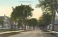 School Street c. 1910
 -
 Public Library c. 1910
 -
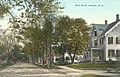 Bank Street c. 1910


Geography
According to the United States Census Bureau, the city has a total area of 41.3 square miles (106.9 km2), of which 40.3 square miles (104.4 km2) are land and 0.97 square miles (2.5 km2) are water, comprising 2.35% of the city.[7] The western boundary of Lebanon is the Connecticut River, which is also the state boundary with Vermont. The village of West Lebanon occupies the western part of the city, along the Connecticut River. Downtown Lebanon is 3 miles (5 km) to the east, along the Mascoma River, a tributary of the Connecticut. The city is fully within the Connecticut River watershed.[8] The southern end of Moose Mountain is in the northeast. The highest point in Lebanon is the northern end of Shaker Mountain, at 1,657 feet (505 m) above sea level, on the eastern border of the city.
Climate
According to the
| Climate data for Lebanon, New Hampshire, 1991–2020 normals, extremes 1948–present | |||||||||||||
|---|---|---|---|---|---|---|---|---|---|---|---|---|---|
| Month | Jan | Feb | Mar | Apr | May | Jun | Jul | Aug | Sep | Oct | Nov | Dec | Year |
| Record high °F (°C) | 67 (19) |
68 (20) |
85 (29) |
91 (33) |
96 (36) |
99 (37) |
99 (37) |
98 (37) |
95 (35) |
87 (31) |
80 (27) |
69 (21) |
99 (37) |
| Mean maximum °F (°C) | 50.9 (10.5) |
52.0 (11.1) |
62.7 (17.1) |
80.5 (26.9) |
88.3 (31.3) |
91.8 (33.2) |
92.9 (33.8) |
90.8 (32.7) |
88.0 (31.1) |
77.4 (25.2) |
65.8 (18.8) |
55.2 (12.9) |
94.7 (34.8) |
| Mean daily maximum °F (°C) | 30.3 (−0.9) |
33.9 (1.1) |
43.0 (6.1) |
56.6 (13.7) |
69.7 (20.9) |
77.9 (25.5) |
82.7 (28.2) |
81.1 (27.3) |
72.9 (22.7) |
59.8 (15.4) |
46.8 (8.2) |
35.5 (1.9) |
57.5 (14.2) |
| Daily mean °F (°C) | 19.8 (−6.8) |
22.4 (−5.3) |
31.9 (−0.1) |
44.3 (6.8) |
56.7 (13.7) |
65.1 (18.4) |
70.3 (21.3) |
68.6 (20.3) |
60.7 (15.9) |
48.6 (9.2) |
37.2 (2.9) |
26.8 (−2.9) |
46.0 (7.8) |
| Mean daily minimum °F (°C) | 9.3 (−12.6) |
11.0 (−11.7) |
20.7 (−6.3) |
31.9 (−0.1) |
43.7 (6.5) |
52.4 (11.3) |
57.8 (14.3) |
56.2 (13.4) |
48.6 (9.2) |
37.4 (3.0) |
27.7 (−2.4) |
18.1 (−7.7) |
34.6 (1.4) |
| Mean minimum °F (°C) | −15.5 (−26.4) |
−12.4 (−24.7) |
−2.7 (−19.3) |
18.4 (−7.6) |
28.5 (−1.9) |
38.4 (3.6) |
46.9 (8.3) |
44.4 (6.9) |
34.4 (1.3) |
22.5 (−5.3) |
13.0 (−10.6) |
−5.6 (−20.9) |
−19.4 (−28.6) |
| Record low °F (°C) | −34 (−37) |
−30 (−34) |
−26 (−32) |
2 (−17) |
20 (−7) |
30 (−1) |
38 (3) |
30 (−1) |
20 (−7) |
13 (−11) |
−10 (−23) |
−27 (−33) |
−34 (−37) |
| Average precipitation inches (mm) | 2.29 (58) |
2.10 (53) |
2.70 (69) |
2.99 (76) |
3.32 (84) |
3.80 (97) |
3.99 (101) |
3.62 (92) |
3.44 (87) |
4.00 (102) |
2.98 (76) |
2.84 (72) |
38.07 (967) |
| Average snowfall inches (cm) | 19.0 (48) |
17.1 (43) |
11.5 (29) |
3.4 (8.6) |
0.1 (0.25) |
0.0 (0.0) |
0.0 (0.0) |
0.0 (0.0) |
0.0 (0.0) |
0.2 (0.51) |
4.4 (11) |
16.4 (42) |
72.1 (182.36) |
| Average extreme snow depth inches (cm) | 14.8 (38) |
17.7 (45) |
13.2 (34) |
3.5 (8.9) |
0.1 (0.25) |
0.0 (0.0) |
0.0 (0.0) |
0.0 (0.0) |
0.0 (0.0) |
0.2 (0.51) |
3.2 (8.1) |
9.7 (25) |
19.0 (48) |
| Average precipitation days (≥ 0.01 in) | 10.5 | 10.3 | 10.9 | 12.1 | 13.9 | 14.7 | 14.5 | 13.6 | 12.5 | 13.5 | 11.4 | 12.4 | 150.3 |
| Average snowy days (≥ 0.1 in) | 7.5 | 5.9 | 4.8 | 1.4 | 0.0 | 0.0 | 0.0 | 0.0 | 0.0 | 0.1 | 2.4 | 6.8 | 28.9 |
| Source 1: NOAA[10] | |||||||||||||
| Source 2: National Weather Service[9] | |||||||||||||
Demographics
| Census | Pop. | Note | %± |
|---|---|---|---|
| 1790 | 1,180 | — | |
| 1800 | 1,574 | 33.4% | |
| 1810 | 1,808 | 14.9% | |
| 1820 | 1,710 | −5.4% | |
| 1830 | 1,868 | 9.2% | |
| 1840 | 1,754 | −6.1% | |
| 1850 | 2,127 | 21.3% | |
| 1860 | 2,322 | 9.2% | |
| 1870 | 3,094 | 33.2% | |
| 1880 | 3,354 | 8.4% | |
| 1890 | 3,703 | 10.4% | |
| 1900 | 4,965 | 34.1% | |
| 1910 | 5,718 | 15.2% | |
| 1920 | 6,162 | 7.8% | |
| 1930 | 7,073 | 14.8% | |
| 1940 | 7,590 | 7.3% | |
| 1950 | 8,495 | 11.9% | |
| 1960 | 9,299 | 9.5% | |
| 1970 | 9,725 | 4.6% | |
| 1980 | 11,134 | 14.5% | |
| 1990 | 12,183 | 9.4% | |
| 2000 | 12,568 | 3.2% | |
| 2010 | 13,151 | 4.6% | |
| 2020 | 14,282 | 8.6% | |
| 2021 (est.) | 15,005 | [11] | 5.1% |
| U.S. Decennial Census[4][12] | |||

As of the
There were 6,186 households, out of which 24.2% had children under the age of 18 living with them, 40.5% were married couples living together, 8.9% had a female householder with no husband present, 3.4% had a male householder with no wife present, and 47.2% were non-families. 36.8% of all households were made up of individuals, and 12.4% were someone living alone who was 65 years of age or older. The average household size was 2.10, and the average family size was 2.76.[13]
In the city, the population was spread out, with 20.5% from age 0-19, 6.3% from 20 to 24, 30.3% from 25 to 44, 27.6% from 45 to 64, and 15.3% who were 65 years of age or older. The median age was 39.4 years. The male population was 47.4% of the total, while the female population was 52.6%.[13]
For the period 2011–2015, the estimated median annual income for a household in the city was $53,004, and the median income for a family was $75,511. Male full-time workers had a median income of $51,735 versus $48,836 for females. The per capita income for the city was $36,370. About 8.7% of families and 12.3% of the entire population were below the poverty line, including 22.6% of those under 18 and 5.0% of those age 65 and over.[14]
Government and politics
The city government consists of a
Politically the city is strongly Democratic. Joe Biden received 74% of the vote to Donald Trump's 25% in the 2020 United States presidential election.
Education
Lebanon has its own elementary schools, middle school, and high school. Students from neighboring towns (Grantham and Plainfield[15]) attend high school in Lebanon. On October 15, 2010, the city broke ground on a new middle school for grades 5–8 to replace an aging junior high facility and overcrowded elementary school facilities.[16] Lebanon Middle School was completed in 2012.
Located on the downtown pedestrian mall is the Lebanon campus of
Transportation
Roads and highways

Lebanon is served by
Public transportation
Lebanon Airport, adjacent to West Lebanon, has passenger service to Boston and New York City provided by Cape Air. Free public bus service for the major towns in the area including Lebanon is provided by Advance Transit, with weekday service to destinations such as Dartmouth–Hitchcock Medical Center, shopping plazas in West Lebanon, the villages of Lebanon and West Lebanon, as well as Hanover and White River Junction. Southeast Vermont Transit also provides a peak direction commuter bus route between DHMC to Bellows Falls, Vermont that also runs on weekdays.
The closest Greyhound bus terminal and Amtrak train station are both located in White River Junction, Vermont. [18][19] Dartmouth Coach offers daily express bus service to Boston's Logan Airport and to New York City.
Culture
Downtown Lebanon is a cultural hub with attractions such as the Lebanon Opera House (in City Hall), the AVA Gallery, seasonal Farmers' Market and summer concerts on the green. Opera North, based in the city, is the region's oldest professional opera company.
Lebanon Public Library, located downtown on East Park Street, is the primary library in the city, and the Kilton Public Library branch serves West Lebanon. Kilton was the first library in the U.S. to host a node of the Tor anonymity network.[20]

The Carter Community Building Association (CCBA) operates an after-school activity center for primary school children and a fitness center for teens and adults. Salt Hill Pub frequently features live musical performances.
Colburn Park
The Colburn Park Historic District is at the heart of Lebanon, consisting of Colburn Park and buildings around it—and many 19th-century buildings immediately adjacent to these. The district was listed on the National Register of Historic Places in 1986. The land that later developed into the park was donated in 1792 by Robert Colburn as the site for the community's meeting house, serving the purposes of church and town hall. Arterial roads were built to the area, and it began to develop as a commercial and civic center in the early 19th century. A weekly farmers' market is held there between June and September along with many community activities throughout the year.
-
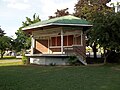 Stage
Stage -
 War memorial
 -
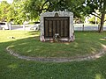 War memorial
 -
 Plaque
 -
 Fountain


Notable people
- Nick Alexander (born 1988), 2010 and 2014 US Olympic Team ski jumper[21]
- Aaron Baddeley (born 1981), golfer with the PGA Tour; born in Lebanon
- Minnie Willis Baines Miller(1845–1923), author
- William Wallace Smith Bliss (1815-1853), army officer and mathematician
- Duane R. Bushey (born 1944), naval officer
- Thomas C. Chalmers (1917–1995), physician, researcher
- Benjamin Champney (1817–1907), landscape painter [citation needed]
- Harry Morrison Cheney (1860–1937), Speaker of New Hampshire House of Representatives
- Buff Cobb (1927–2010), actress and talk-show host
- Norris Cotton (1900–1989), US senator
- Aaron H. Cragin (1821–1898), politician
- Lane Dwinell (1906–1997), manufacturer
- Experience Estabrook (1813–1894), lawyer, politician
- Jeff Friedman (born 1950), poet
- Phineas Gage (1823–1860), railroad foreman, massive brain-injury survivor
- Arlie Latham (1860-1952), professional baseball player
- Jedediah Hyde Lathrop (1806-1889), merchant
- Charley Parkhurst (1812–1879), stagecoach driver
- Elisha Payne (1731-1807), businessman and politician
- George Halsey Perley (1857–1938), politician, diplomat
- Phineas Quimby(1802–1866), philosopher
- Colleen Randall (born 1952), artist
- Hezekiah Bradley Smith(1816–1887), inventor
- Joseph Smith (1805–1844), religious leader, founder of Mormonism and the Latter Day Saint movement[22]
- Sarah Strohmeyer (born 1962), author
- William Ticknor (1810–1864), publisher
- Mia Tyler (born 1978), model, actress
- Rob Woodward (born 1962), pitcher with the Boston Red Sox, radio host
- Ammi B. Young (1798–1874), architect
References
- ^ "US Gazetteer files: 2010, 2000, and 1990". United States Census Bureau. February 12, 2011. Retrieved April 23, 2011.
- ^ "ArcGIS REST Services Directory". United States Census Bureau. Retrieved September 20, 2022.
- ^ "Metropolitan and Micropolitan Statistical Areas Population Totals and Components of Change: 2020-2021". U.S. Census Bureau. Retrieved May 27, 2022.
- ^ a b "Lebanon city, Grafton County, New Hampshire: 2020 DEC Redistricting Data (PL 94-171)". U.S. Census Bureau. Retrieved November 18, 2021.
- ^ "Geographic Identifiers: 2010 Demographic Profile Data (G001): Lebanon city, New Hampshire". U.S. Census Bureau, American Factfinder. Archived from the original on February 13, 2020. Retrieved January 3, 2017.
- ^ "History of Lebanon, NH". January 24, 2014.
- ^ "2021 U.S. Gazetteer Files – New Hampshire". United States Census Bureau. Retrieved November 18, 2021.
- ^ Foster, Debra H.; Batorfalvy, Tatianna N.; Medalie, Laura (1995). Water Use in New Hampshire: An Activities Guide for Teachers. U.S. Department of the Interior and U.S. Geological Survey.
- ^ a b "NOAA Online Weather Data - NWS Gray/Portland". National Weather Service. Retrieved November 1, 2022.
- ^ "U.S. Climate Normals Quick Access - Station: Lebanon MUNI AP, NH". National Oceanic and Atmospheric Administration. Retrieved November 1, 2022.
- ^ "U.S. Census Bureau QuickFacts Lebanon, New Hampshire". U.S. Census Bureau. Retrieved May 27, 2022.
- ^ "Census of Population and Housing". Census.gov. Retrieved June 4, 2015.
- ^ a b c "Profile of General Population and Housing Characteristics: 2010 Census Summary File 1 (DP-1): Lebanon city, New Hampshire". U.S. Census Bureau, American Factfinder. Archived from the original on February 13, 2020. Retrieved January 3, 2017.
- ^ "Selected Economic Characteristics: 2011-2015 American Community Survey 5-Year Estimates (DP03): Lebanon city, New Hampshire". U.S. Census Bureau, American Factfinder. Archived from the original on February 13, 2020. Retrieved January 3, 2017.
- ^ "Lebanon School District Information". Lebanon School District. Archived from the original on May 14, 2011. Retrieved September 4, 2009.
- ^ "Lebanon Middle School Project". Lebanon School District. Archived from the original on September 18, 2010. Retrieved October 25, 2010.
- ^ "AVA gallery, Lebanon, New Hampshire".
- ^ Stations - White River Junction (WRJ), Amtrak. Retrieved 2017-07-17.
- ^ White River Jct Vermont Bus Station, Greyhound. Retrieved 2017-07-17.
- ^ "Despite Law Enforcement Concerns, Lebanon Board Will Reactivate Privacy Network Tor at Kilton Library | Valley News". Archived from the original on September 18, 2015. Retrieved November 20, 2015.
- ^ "Olympic Ski Jumping Team Named". US Ski Team. January 20, 2010. Archived from the original on September 1, 2010. Retrieved January 21, 2010.
- ^ Teachings of Presidents of the Church. Salt Lake City, Utah: Church of Jesus Christ of Latter Day Saints. 2007.
- ISBN 9780802025401.
External links
- Official website
- Lebanon Historical Society
- Lebanon Public Libraries
- Lebanon School District
- New Hampshire Economic and Labor Market Information Bureau Profile
Places adjacent to Lebanon, New Hampshire | |
|---|---|
 | ||||
| Towns |
| |||
| Township | ||||
| CDPs | ||||
Other villages | ||||
| ||||
| International | |
|---|---|
| National | |
| Geographic | |