
Rein da Medel
This article needs additional citations for verification. (January 2017) |
| Rein da Medel | |
|---|---|
Graubünden | |
| Physical characteristics | |
| Source | |
| • coordinates | 46°34′10″N 8°41′44″E / 46.56944°N 8.69556°E |
| • elevation | 2,500 m (8,200 ft) |
Disentis/Mustér, | |
• coordinates | 46°41′46″N 8°51′18″E / 46.69611°N 8.85500°E |
• elevation | 1,047 m (3,435 ft) |
| Length | 25.4 km (15.8 mi) |
| Basin size | 127.7 km2 (49.3 sq mi) |
| Basin features | |
| Progression | Vorderrhein→ Rhine→ North Sea |
| Tributaries | |
| • right | Rein da Cristallina, Rein da Plattas |
The Rein da Medel (
The most important place along the river is the village Curaglia in the municipality of Medel.
Course of the river
The headwaters of the Rein da Medel flow through the Val Cadlimo, a small west-east valley south of the main Alpine ridge in the municipality of
There are three almost equally strong source streams:
- The southern spring trickle flows through the Lago Scuro (2,450 m (8,040 ft) and thereafter becomes a creek, between Punta Negra and Bassa del Lago Scuro (a pass).
- The central spring trickle rises on the Bocchetta di Cadlimo (a pass at 2,533 m (8,310 ft)) and shortly thereafter flows through the Lago di Dentro (2,504 m (8,215 ft)).
- The northern spring trickles rise beneath the Pizzo Curnera (2,796 m (9,173 ft)).
The northern spring trickles are about 640 meters long. The southern and western spring creeks are about 1,000 meters from their start to the confluence before the Lago dell'Isra (2,321 m (7,615 ft)). 46°33′56″N 8°42′18″E / 46.5656°N 8.7051°E.
About four kilometers to the east after the Lago dell'Isra at the end of its first valley, the Val Cadlimo, the Reno di Medel forms a steep little
Now in the Grisons, the creek flows through the
The middle and lower sections of the river flows through the Val Medel it created. Most of this section belongs to the municipality of
Flow lengths
The total flow length of the net since Medel is about 25.4 km. The lengths of the various sections are approximately:
- Southern headwater: 0.99 km
- Western headwater: 1.00 km
- Northern headwater: 0.64 km
- Reno di Medel (upper reaches of the Val Cadlimo, plus part of the middle reaches in Ticino, excluding Lai da Sontga Maria): 6.76 km
- Lai da Sontga Maria: 2.67 km
- Froda (dried part of the middle reaches without Lai da Santa Maria): 5.91 km
- Reno di Medel (lower reaches): 9.05 km
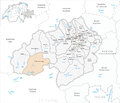
Neighboring river basins
The key neighboring river basins in the Rhine system, those of the Reno Anteriur (
Gallery
-
 View over the Lai da Sontga Maria to the south: to the far right is the entrance to the gorge of the lower Val Cadlimo; also on the right: a view into Val Termine towards Passo dell 'Uomo; on the left: the passage towards Lukmanier Pass and the ticineseValle Santa Maria
 -
 Map of the municipality of Medel, with poorly mapped Rein da Medel
 -
 Cantonal border demarcation in the area (Olivone now belongs to Blenio).
 -
 Froda (middle section of the Rein da Medel), facing north
 -
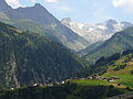
 View over the lower reaches of the Rein da Medel, facing north. In the foreground Platta; in the background Curaglia. The ravine that the Rein da Medel has eroded into the bottom of the U-shaped glacial valley, is clearly visible.
 -
 Retaining wall of the Lai da Maria Sontga
 -
 Views over Curaglia towards Anterior Rhine Valley with the Benedictine Abbey of Disentis
 -
 View towards Medel Glacier

_2007.png)


Footnotes
- ^ For example, by cantonal and federal authorities
