
Ahr
| Ahr | |
|---|---|
North Rhine-Westfalia, Germany | |
| • coordinates | 50°26′17″N 6°38′58″E / 50.438°N 6.6494°E |
| • elevation | 470 m (1,540 ft) |
| Mouth | Rhine |
• location | Remagen, Rhineland-Palatinate, Germany |
• coordinates | 50°33′34″N 7°16′37″E / 50.55944°N 7.27694°E |
• elevation | 58 m (190 ft) |
| Length | 89 km (55 mi) |
| Basin size | 900 km2 (350 sq mi) |
| Discharge | |
| • average | 8.9 m3/s (310 cu ft/s) |
| Basin features | |
| Progression | Rhine→ North Sea |
Ahr (German pronunciation: [ˈaːɐ̯]) is a river in Germany, a left tributary of the Rhine. Its source is at an elevation of approximately 470 metres (1,540 ft) above sea level in Blankenheim in the Eifel, in the cellar of a timber-frame house near the castle of Blankenheim. After 18 kilometres (11 mi) it crosses from North Rhine-Westphalia into Rhineland-Palatinate.
The Ahr flows through
The Ahr and its tributaries are a main drainage system of the eastern Eifel. The watershed is approximately 900 square kilometres (350 sq mi).
History
There were isolated settlements in the Ahr valley beginning at the latest in Roman times, evidenced by the Roman villa near Ahrweiler. Owing to their isolated location, the upper and middle parts of the course were sparsely populated.
That began changing in the mid-19th century. The development of settlements and transportation routes (including three railway lines) and the expansion of the area used for agriculture in the Ahr valley led to the narrowing and constraint of the riverbed. The course of the river was graded and its banks were stabilized.
Catastrophic flash flooding occurred on the Ahr in 1910 and 2021 resulting in the deaths of hundreds.
Course
The Ahr rises in the middle of the village of
The stream, which runs in a south-easterly direction, through the valley meadows of upper Ahr valley, has not cut very deeply into the heights of the Eifel. Much of the upper Ahr valley is protected and follows the
The mouth of the Ahr lies on the plain of the Golden Mile, between the Remagen district of Kripp and the town of Sinzig at a height of about 53 m above NHN[1]. Since being re-naturalised (from 1979, see aerial photographs) it has been one of the few natural river mouths on the Rhine and is under protection.[2]
- Ahr - Source, Valley, Mouth
-
 Source of the Ahr (in front of the head) in Blankenheim
 -
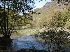 The middle Ahr below Altenahr with the rock formation of Langfig
 -
 The Ahr by the Bunte Kuh rock formation at Walporzheim
 -
 The mouth of the Ahr on the Rhine before re-naturalisation (1957)
 -
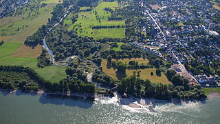 The mouth of the Ahr after re-naturalisation. Right: this village of Kripp


Tributaries
The tributaries of the Ahr include (in upstream order):[3]
| Name | Waterbody No. (GKZ) | Length (km) | Direction | Confluence at km |
Place | Remarks |
|---|---|---|---|---|---|---|
| Stegbach | 27181112 | 2.2 | right | 84.9 | Blankenheim
|
|
| Mülheimer Bach | 2718112 | 4.5 | left | 83.1 | ||
| Nonnenbach | 271812 | 7.0 | right | 82.5 | ||
| Reetzer Bach | 2718132 | 3.6 | left | 80.5 | Reetz | |
| Schaafbach | 271814 | 11.4 | right | 79.2 | headstream: Eichholzbach | |
| Lampertsbach | 271816 | 9.5 | right | 75.7 | Dollendorf | headstream: Frömmelsbach |
| Fuhrbach | 2718172 | 5.3 | right | 74.6 | Ahrhütte | |
| Mühlenbach | 271818 | 7.1 | left | 74.0 | Ahrhütte | headstream: Weilerbach |
| Michelsbach | 2718192 | 8.3 | right | 73.2 | ||
| Aulbach | 2718194 | 5.1 | left | 72.9 | ||
| Willemsbach | 27181992 | 1.4 | right | 71.1 | Uedelhoven | |
| Göttersbach | 27181994 | 1.0 | right | 70.7 | Ahrdorf
|
|
| Ahbach | 27182 | 14.9 | right | 68.8 | Ahrdorf
|
|
| Trierbach[4] | 27184 | 25.3 | right | 64.2 | Müsch | |
| Huhnenbach | 271852 | 4.3 | left | 61.1 | Antweiler | |
| Limbach | 2718532 | 3.9 | right | 60.3 | Antweiler | |
| Eichenbach | 2718534 | 6.9[4] | left | 58.7 | headstream: Hirzenflosseifen | |
| Laufenbach | 2718536 | 2.8 | right | 55.5 | Fuchshofen | |
| Dreisbach | 271854 | 10.0 | left | 55.4 | Fuchshofen | |
| Armuthsbach | 271856 | 18.4 | left | 52.0 | Schuld
|
|
| Holzseifen | 2718574 | 1.0 | left | 47.9 | Schuld
|
|
| Atzenbach | 2718576 | 2.5 | left | 47.5 | ||
| Lückenbach | 271858 | 5.7 | right | 45.3 | Insul | |
| Adenauerbach | 27186 | 15.7[4] | right | 44.7 | Dümpelfeld | |
| Ommelbach | 2718712 | 1.8 | right | 43.6 | Dümpelfeld | |
| Liersbach | 271872 | 14.5 | left | 42.8 | Liers
|
|
| Kesselinger Bach[4] | 271874 | 14.1 | right | 95.0 | Ahrbrück | |
| Steinbach | 271876 | 2.5 | left | 38.3 | Ahrbrück | |
| Stream from Schorling | 271878 | 2.5 | left | 38.2 | Ahrbrück | |
| Sahrbach | 27188 | 15.3 | left | 34.0 | Kreuzberg
|
|
| Vischelbach | 271892 | 10.5 | left | 33.9 | Kreuzberg
|
|
| Stream from Burtscheiderberg (Roßbach) | 2718932 | 2.2 | left | 31.5 | Altenahr | |
| Stream from Sonnenheck (Junge Berren[4]) | 2718934 | 1.8 | right | 22.0 | Rech | |
| Nollbach (Donnenbach[4]) | 271894 | 1.8 | right | 21.9 | Rech | |
| Kratzenbach | 27189512 | 2.1 | left | 18.3 | Dernau | |
| Geusbach | 2718952 | 2.4 | right | 16.8 | Walporzheim
|
|
| Wingsbach | 271896 | 4.5 | right | 15.1 | Ahrweiler
|
|
| Mühlenteichgraben | 27189712 | 1.0 | left | 14.5 | Bad Neuenahr
|
|
| Bachemer Bach | 2718972 | 7.0 | right | 12.9 | Bad Neuenahr
|
|
| Fuchsbach | 2718974 | 4.5 | left | 11.4 | Bad Neuenahr
|
|
| Mühlenteich | 27189752 | 1.2 | right | 9.6 | Bad Neuenahr
|
|
| Idienbach | 2718976 | 5.3 | right | 9.2 | Heimersheim | |
| Leimersdorfer Bach[4] | 271898 | 8.5 | left | 8.7 | Heppingen | |
| Lohrsdorfer Bach[4] | 2718992 | 2.5 | left | 7.0 | Lohrsdorf | |
| Hellenbach[4] | 2718996 | 7.7 | right | 3.1 | Sinzig | |
| Harbach[4] | 2718998 | 9.9 | left | 2.5 | Sinzig |
Tributaries with a length of over 7 km (from source to mouth): Left tributaries are in dark blue; right tributaries in light blue.

Viticulture

The Ahr is well known for the many vineyards that grace the hillsides downstream of the village of
See also
- Golden Mile (Rhineland-Palatinate), the fertile plain at the mouth of the Ahr
- List of rivers of Rhineland-Palatinate
- List of rivers of North Rhine-Westphalia
References
- ^ Map service of the Landscape Information System of the Rhineland-Palatinate Nature Conservation Office (Naturschutzverwaltung Rheinland-Pfalz)
- ^ "Rechtsverordnung über das Naturschutzgebiet Mündungsgebiet der Ahr" (pdf). Landkreis Ahrweiler. 1981-06-23. Archived (PDF) from the original on 2014-01-02. Retrieved 2014-01-02.
- ^ Hydrographic Directory of the NRW State Office for Nature, the Environment and Consumer Protection (Gewässerverzeichnis des Landesamtes für Natur, Umwelt und Verbraucherschutz NRW 2010) (xls; 4.67 MB)
- ^ a b c d e f g h i j Geoexplorer of the Rhineland-Palatinate Water Authority (Wasserwirtschaftsverwaltung Rheinland-Pfalz)
External links
- AhrtalGuide.com[permanent dead link] Pictures of this region (in German)
- Ahr 2000 (in German)

| International | |
|---|---|
| National | |