
Kinzig (Rhine)
| Kinzig | |
|---|---|
 The Kinzig in Wolfach | |
.png) Course of the Kinzig | |
| Location | |
| Country | Germany |
| State | Baden-Württemberg |
| Reference no. | DE: 234 |
| Physical characteristics | |
| Source | |
| • location | Loßburg |
| • elevation | 682 m |
| Mouth | |
• location | In Kehl-Auenheim |
• elevation | 134 m |
| Length | 93.3 km (58.0 mi) [1] |
| Basin size | 1,403 km2 (542 sq mi) [1] |
| Discharge | |
| • location | at Schwaibach gauge [2] |
| • average | 22.8 m³/s |
| • minimum | Record low: 1.08 m³/s (in 14.09.1919) Average low: 3.62 m³/s |
| • maximum | Average high: 296 m³/s Record high: 914 m³/s (in 24.12.1919) |
| Basin features | |
| Progression | Wolf, Harmersbach |
The Kinzig is a river in southwestern Germany, a right tributary of the Rhine.
It runs for 93 km from the
Course of the river
The origin of the Kinzig is located on the land of the town of
Name
In 1099 the river was first mentioned as ad Chinzechun, ad aliam Chinzichun, in 1128 as Kinzicha. In 1539, 1543, 1560, 1620, 1652 and 1654 it was listed as Künzlin, Küntzgen, Kintzg, Kintzgen, Oberkentzgenwüß and Köntzig, respectively. In 1837 it was referred to for the first time as Kinzig.
According to
With all these possibilities in mind, we can return to Adolf Bach and Bruno Boesch, who think these derivations doubtful. In addition, the question remains of how far the Celts or Pre-Celts had settled the Kinzig area, and which settlers had originally given the river its name. While these questions are difficult to answer for pre-historic times, the fact is that the Kinzig only created a small canyon in its upper part. A completely different river with many twists and turns presents itself as it moves towards the
Tributaries
In the Black Forest many tributaries empty into the Kinzig, including several longer streams of 20-30 kilometres in length, most coming from the north or south. The following is a list of those over 10 kilometres in length:
- Little Kinzig, from the right near the Schenkenzellrailway bridge, 20.2 km and 62.9 km².
- Schiltach, from the left in Schiltach, 29.5 km and 115.8 km².
- Wolf, formerly the Wolfach, from the right in Wolfach, 30.8 km and 129.6 km².
- Gutach, from the left near Gutach (Schwarzwaldbahn), 29.3 km and 161.5 km².
- Mühlbach or Steinach, 10.5 km and 24.9 km².
- Biberach, 18.9 km (together with the rather larger Harmersbach, the much longer of its two headstreams, the Harmersbach and the Nordrach) and 102.9 km².
The largest tributary overall reaches the Kinzig a little before its mouth in the Upper Rhine Plain:
Importance as a transport and trade route
Timber rafting

In the past, the Kinzig was very important for
Historical Roman road

The width, length and the favourable east-west direction of the middle and lower valley of the Kinzig make it important for as a communication route. For example, the
Fauna and flora
Fauna
A regeneration program has been in progress since 2002 to re-introduce salmon into the Kinzig by putting young salmon into the water and removing obstacles. These efforts seem to be successful as in early 2005, for the first time in 50 years, salmon spawn were found in a river in Baden-Württemberg.
Flora
The Kinzig valley is the deepest in the inner Black Forest. In the lower Kinzig valley the villages are below 200 metres above sea level. The climate in the valley is therefore milder than in most other areas of the Black Forest. In the lower valley fruit and wine are produced; Gengenbach, Ortenberg and Ohlsbach are well-known names of wine-growing villages, some of which are on the Baden Wine Road. The countryside around the Kinzig valley in spring blooms far earlier than the surrounding regions of the Black Forest.
Infrastructure
The width, length and favourable east-west direction in the middle and lower valley make the Kinzig Valley important for infrastructure. The
Roughly at the same time that the Kinzigtalstraße was built, Roman forts were constructed further north on the right side of the
In 98 AD, in the area of present-day southwest Germany, the route between Odenwald and Neckar came under Roman control, making the connection from Mainz to Augsburg shorter yet. As a result, the Kinzigtalstraße lost superregional significance.
In present-day Germany, the federal highway B 33 runs parallel to the Kinzig from Offenburg until it leaves the Kinzig in the upper valley to follow the Gutach towards Villingen-Schwenningen. From Hausach on towards Freudenstadt, the federal highway B 294, follows the upper Kinzig.
For the Black Forest Railway (Schwarzwaldbahn) train service, the valley is also very important. It runs from Offenburg to Hausach where it turns into the Gutach Valley to continue on to Konstanz at Lake Constance. In the upper Kinzig Valley, the Kinzig Valley Railway (Kinzigtalbahn) provides a connection between Hausach and Freudenstadt.


Towns and villages
(starting at the origin)
|
Castles, abbeys and stately homes
- Gallery
-
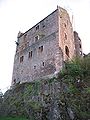
 The Schenkenburg near Schenkenzell
 -
 Schloss Wolfach
 -
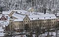
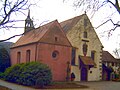 Abbey church and Loretto Chapel of the Capuchin abbey in Haslach, Feb 2006
 -
 The ruins of Hohengeroldseck
 -
 Gengenbach Abbey
 -
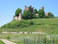 Schloss Ortenberg, May 2008


- Alpirsbach Abbey, Alpirsbach
- Schenkenburg Castle, Schenkenzell
- Schiltach Castle, Schiltach
- Willenburg Castle, Schiltach
- Schloss Wolfach, Wolfach
- Husen Castle, Hausach
- Haslach Abbey, Haslach
- Biberach (Baden)
- Gengenbach Abbey, Gengenbach
- Ortenberg (Baden)
See also
References
Sources
- Emil Imm (ed.) - Land um Kinzig und Rench, Rombach-Verlag (1974)
- Kurt Klein - Leben am Fluss, Schwarzwald-Verlag (2002)
- STALF, A. (1932): Korrektion und Unterhaltung der Kinzig. Die Ortenau 19. pp 124–144.
- NEUWERCK, A. (1986): Der Lachsfang in der Kinzig. Die Ortenau 66. pp 499–525.
- Bach, Adolf, Deutsche Namenkunde, Bd. II/2, Heidelberg 1981
- Bahlow, Hans, Deutschlands geographische Namenwelt, Frankfurt 1985, p. 263
- Boesch, Bruno, Kleine Schriften zur Namenforschung, Heidelberg 1981
- Buck, M. R., Oberdeutsches Flurnamenbuch, Stuttgart 1880, p. 130
- Keinath, Walther, Orts- und Flurnamen in Württemberg, Stuttgart 1951
- Krahe, Hans, Unsere ältesten Flussnamen, Wiesbaden 1964
- Obermüller, Wilhelm, Deutsch – Keltisches Wörterbuch, 1872, Reprint-Druck, Vaduz 1993, Bd. II, pp 178f
- Springer, Otto, Die Flussnamen Württembergs und Badens, Stuttgart 1930, pp 53, 60
- Traub, Ludwig, Württembergische Flußnamen aus vorgeschichtlicher Zeit in ihrer Bedeutung für die einheimische Frühgeschichte, in: Württembergische Vierteljahrshefte für Landesgeschichte, XXXIV. Jahrgang, 1928, Stuttgart 1929, p. 16
External links
- Tourism site of the Kinzig Valley communities
- Rafters' Museum Gengenbach
- (in German) History of Rafting in Schiltach
- (in German) Information about and images

| Authority control databases: National |
|---|