
Wutach (river)
| Wutach | |
|---|---|
 The Wutach at Tiengen between the mouths of the Steina and Schlücht | |
 Map showing the course of the Wutach and its relation the Rhine (Rhein) and Danube (Donau) | |
| Location | |
| Countries | Germany and Switzerland |
| Physical characteristics | |
| Source | |
| • location | On the Seebuck (Black Forest) as the Seebach |
| • coordinates | 47°52′14″N 8°00′59″E / 47.87056°N 8.01639°E |
| • elevation | 1,440 m (4,720 ft) |
| Mouth | |
• location | The Rhine near Waldshut-Tiengen |
• coordinates | 47°36′51″N 8°14′59″E / 47.61417°N 8.24972°E |
• elevation | 315 m (1,033 ft) |
| Length | 91.1 km (56.6 mi) [1] |
| Basin size | 1,139.3 km2 (439.9 sq mi) [1] |
| Discharge | |
| • average | 16.1 m3/s (570 cu ft/s) |
| Basin features | |
| Progression | Rhine→ North Sea |
| Tributaries | |
| • left | Kotbach (mouth river of the Klettgau rivers, the Klingengraben and the Schwarzbach) |
| • right | Schlücht, Steina |
| Waterbodies | Feldsee, Titisee |
The Wutach is a river, 91 kilometres long, in the southeastern part of the Black Forest in the German state of Baden-Württemberg. It is a right-hand tributary of the Rhine. In its lower reaches it flows for about 6 kilometres along the border with the canton of Schaffhausen, Switzerland.
Name
The name Wutach means "furious water", referring to the whitewater rapids in the gorge. Wut is recognisably cognate to a modern German word for anger; ach, which forms part of the names of many rivers in the region, comes from an old Celtic word for water, cognate with Latin aqua.
Course
The river changes its name twice before it discharges into the High Rhine near Waldshut:
It rises in the
.jpg)

From the Titisee the sluggishly flowing meadow river is called the Gutach ("good stream"). Before Neustadt it swings sharply through 90° to the right and heads southeast in the direction of the almost equally large Josbach/Langenordnach. Below the town, two large bridges cross the valley: the Gutach Viaduct carrying the B 31 and the Gutach Bridge with the Höllental Railway. From here on the river rushes through an ever deepening gorge.
From the confluence where the river acquires the name Wutach, it flows ESE through a series of three gorges with a total length of more than 30 km (19 mi) and a maximum depth of 160 m (520 ft) (see Wutach Gorge) which has long been a tourist attraction. Between the second and the last part of the gorge, near the village of Achdorf in the municipality of Blumberg, it takes a sharp turn (known as the Wutachknie or Knee of the Wutach), and subsequently flows SW to join the Rhine near Tiengen in the town of Waldshut-Tiengen.
At the Wutachknie the river is very close to the headwaters of the
The lower Wutach valley is straight, wide-bottomed and very densely populated. The river forms the border between Germany and Switzerland for two sections that total about 6 kilometres in length, after which it is canalised. The most important settlements in this part of the valley are the town of Stühlingen and the villages of Eggingen and Wutöschingen.

Before
The stretch of the Wutach is the site of two remarkable railways. The upper stretch of the first gorge is crossed and followed by the so-called Höllentalbahn. The valley just below the third gorge is the site of the Wutach Valley Railway, officially known in German as the Wutachtalbahn but commonly known as the Sauschwänzlebahn (pigtail) because it proceeds in a series of tight turns, including crossing back over itself, in order to make a substantial increase in height without exceeding a 1:100 gradient.
Catchment
The Wutach drains almost the entire south-eastern slopes of the Black Forest. There, its waters first flow through
The average annual discharge depths of the catchment area vary considerably; ranging from over 1,100 mm in the High Black Forest to less than 300 mm in the Klettgau.[3] The visible depth of the Wutach in its river bed, is much lower than would be expected of a river than under natural circumstances drained a catchment of 1,140 km2. This is due to the water siphoned off for the Schluchseewerk power station, which particularly affects its largest tributary, the Schlücht
Owing to its riverbed gradient of, on average, 13 ‰, critical high water often occurs on the Wutach. A well-known historical lithograph shows the valley floor at the Stühlinger Zwirnerei completely covered by water. Its lower reaches were therefore canalised and dyked in order to provide
River history
The lower Wutach flows along the line of the valley once occupied by the much more powerful upper
The
In its upper course, the Wutach (as the "Gutach") forms another knee; it flows into the former main valley, which began at about the Kandel, but was cut off and redirected a long time ago by the Wild Gutach. Similar river bends in the course of the tributaries from the Black Forest also show (much earlier) re-direction, most strikingly the Schwarza leaving the Schluchsee transversely to the direction of the valley.
In the lower reaches of the Wutach, the Wutach valley flows into the 'Klettgaurinne', and the Wutach then follows the direction of the Kotbach. Until the end of the
Nature reserves
About a third of the course of the Wutach is protected for conservation reasons.
The river rises in the
One of the oldest nature reserves in the country has been the
Further river sections, which are protected, are the natural
-
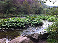 Butterbur colony on the Wutach
 -
 Butterbur colony
 -
 Weevil (Liparus) on butterbur
 -
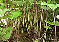
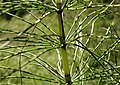 Giant horsetail
 -
 Hairy snail (Trochulus)
 -
 Muschelkalk beds in the Gauchach riverbed
 -
 The Wutach
 -
 Haslach Gorge with the Rechenfelsen rocks


Cultural landscape

From a
For two short sections – between Grimmelshofen and Eggingen – the Wutach is the border river between Germany and Switzerland.
The economic heart of the Wutach region is the town of Waldshut-Tiengen. The major industrial enterprises in the Wutacht valley are
The first attempt to exploit the Wutach by building a dam for energy production was made during the
Territories
Regions
Southern Black Forest and High Rhine
Regional planning regions
Districts
Tributaries
Its
- Sägenbach (from the Feldberg region, empties into the section of the upper Wutach called the Seebach)
- Langenordnach and Josbach (empties into the section of the upper Wutach called the Gutach)
Other tributaries of the middle reaches also form the Wutach Gorge system. In addition to the large river, the
- Haslach
other rivers which are well known are the

- Rötenbach (from the forested eastern slopes of the Black Forest)
- Lotenbach (from the eastern edge of the Black Forest near Bonndorf through the Lotenbach Gorge (Lotenbachklamm))
- Gauchach (with the largest side gorge, the Gauchach Gorge (Gauchachschlucht) and its side gorges (Tränkebach, Mauchach)
- Schleifebach (from the desolate valley stump of the Blumberger Pforte)
In the lower reaches of the Wutach in the Bade region of Klettgau it is joined by the following streams:
- Weilerbach
- Mühlbach (from the Fützen valley accompanied by the winding Wutach Valley Railay)
- Ehrenbach
- Schleitheimer Bach (from the Randental valley, mainly on Swiss soil)
- Mauchenbach
Not until the last eight kilometres of the Wutach is it joined by its three largest tributaries:
| Name |
Length |
Average Flow Rate[4] |
Mouth ca. near |
Mouth height ( m above NN ; ca.)
|
Proportion of Catchment (ca.) | |
|---|---|---|---|---|---|---|
| Kotbach (with the Schwarzbach) | 23.4 km | 1.60 m³/s | km 7.4 | 350 m | 165.4 km2 | 14.6 % |
| Steina | 37.3 km | 1.58 m³/s | km 4.0 | 325 m | 86.1 km2 | 8,3 % |
| Schlücht | 28.9 km | 5.13 m³/s[5] | km 1.2 | 316 m | 234.6 km2 | 21.4 % |
Settlements
The following settlements lie on or near the Wutach:
- Feldberg(southern Seebach valley)
- Hinterzarten (northern Seebach valley)
- Titisee-Neustadt
- Lenzkirch (Haslach-Tal), with Kappel (start of the Wutach Gorge)
- Friedenweiler (with Rötenbach at the start of the Rötenbach Gorge)
- Bonndorf im Schwarzwald (south of the Wutach Gorge)
- Löffingen (north of the Wutach Gorge)
- Ewattingen (village of Wutach, south of the Wutach Gorge)
- Mundelfingen (borough of Hüfingen, north of the Wutach Gorge)
- Aselfingen (borough of Blumberg)
- Achdorf (Stadt Blumberg)
- Blumberg (east of the Wutach Gorge), with Achdorf at the knee of the Wutach
- Stühlingen, with Grimmelshofen at the exit of the Wutach river rockfaces
- Hallau (east of the Wutach, in Switzerland)
- Schleitheim (east of the Wutach, in Switzerland)
- Eggingen
- Wutöschingen
- Horheim
- Lauchringen
- Tiengen
Trails
The upper Wutach area (Seebach valley, Titisee, Schluchsee, Hochfirst) is one of the most important hiking areas of the Black Forest and is covered by a dense network of trails. Through the Wutach Gorge run two main trails maintained by the
- Southern Freiburg-Bodensee Trail
- Ostweg
- Schluchtensteig
South of the Wutach Gorge, from Grimmelshofen downstream, there are footpaths and cycleways by the side of the river.
References
- ^ a b c d Map services of the Baden-Württemberg State Office for the Environment, Survey and Conservation (Landesanstalt für Umwelt, Messungen und Naturschutz Baden-Württemberg)
- ^ Abfluss-BW - regionalisierte Abfluss-Kennwerte Baden-Württemberg
- ^ Walter Wundt: Die mittleren Abflusshöhen und Abflussspenden des Winters, des Sommers und des Jahres in der Bundesrepublik Deutschland, Remagen, 1958, Kartenbeilage
- ^ Geoportal Baden-Württemberg: LUBW-Dienst Fließgewässer – Abfluss-Kennwerte, as at: 8 June 2016
- ^ Note: natural flow rate; its current flow rate has been reduced by diversion into the Schluchseewerk gallery to 0.48 m³/s.
Literature
- Geographisch-Kartographisches Institut Meyer [publ.]: Meyers Naturführer – Südschwarzwald Mannheim, 1989. ISBN 3-411-02775-4.
- Otto F. Geyer et al.: Die Hochrhein-Regionen zwischen Bodensee und Basel = Sammlung Geologischer Führer, 94, Berlin, 2003, ISBN 3-443-15077-2.
- Dieter Kohlhepp: Die Wutachschlucht – Bild einer Urlandschaft. 3rd edn. Rombach Verlag, Freiburg, 1991, ISBN 3-7930-0481-3.
- Landesanstalt für Umweltschutz [Hrsg.]: Die Wutach – Naturkundliche Monographie einer Flusslandschaft = Natur- u. Landsch.-Schutzgeb. Baden-Württ., Vol. 6, Karlsruhe, 1988 ISBN 3-88251-135-4.
- Otti Wilmanns: Exkursionsführer Schwarzwald – eine Einführung in Landschaft und Vegetation Stuttgart, 2001 ISBN 3-8252-2180-6.
Note: Several digital maps erroneously show the course of the Wutach following the former route of the Feldbergdonau, probably as a result of misinterpretation the drainage ditch which links the Schleifebach (Wutach-Nebenbach) and the Aitrach (Danube tributary) and thus forms a pseudo-bifurcation.
External links
- Europäische Wasserrahmenrichtlinie (WRRL) – Teilbearbeitungsgebiet Wutach (PDF-Datei; 1,26 MB)
- Kajaktouren auf der Wutach
- Till Stumpg (ELMM). "Lernmodul "Die Wutach: Grub der Rhein der Donau das Wasser ab?"" (Flash). [WEBGEO] regional / Südwestdeutschland (in German). Institut für Physische Geographie (IPG) der Universität Freiburg. Retrieved 2004-02-01.

Important cities and tourist sites in | |||||||
|---|---|---|---|---|---|---|---|
| Major cities | |||||||
| Other tourist destinations | |||||||
| Landscapes | |||||||
| Neighbouring areas |
| ||||||
| International | |
|---|---|
| National | |
| Other | |