
Ribécourt-la-Tour
Ribécourt-la-Tour | |
|---|---|
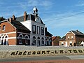
 The town hall in Ribécourt-la-Tour | |
_Nord-France.svg) Coat of arms | |
Location of Ribécourt-la-Tour  | |
 Ribécourt-la-Tour  Ribécourt-la-Tour | |
| Coordinates: 50°06′40″N 3°07′48″E / 50.111°N 3.130°E | |
| Country | France |
| Region | Hauts-de-France |
| Department | Nord |
| Arrondissement | Cambrai |
| Canton | Le Cateau-Cambrésis |
| Intercommunality | CA Cambrai |
| Government | |
| • Mayor (2020–2026) | Christelle Marques[1] |
Area 1 | 8.79 km2 (3.39 sq mi) |
| Population (2022)[2] | 378 |
| • Density | 43/km2 (110/sq mi) |
| Time zone | UTC+01:00 (CET) |
| • Summer (DST) | UTC+02:00 (CEST) |
| INSEE/Postal code | 59500 /59159 |
| Elevation | 59–121 m (194–397 ft) (avg. 74 m or 243 ft) |
| 1 French Land Register data, which excludes lakes, ponds, glaciers > 1 km2 (0.386 sq mi or 247 acres) and river estuaries. | |
Ribécourt-la-Tour (French pronunciation: [ʁibekuʁ la tuʁ]) is a commune in the Nord department in northern France.[3]
Heraldry
|
The arms of Ribécourt-la-Tour are blazoned : Vert, a lion Or, armed and langued gules. (Ribécourt-la-Tour and Robersart use the same arms.)
|
See also
References
- ^ "Répertoire national des élus: les maires" (in French). data.gouv.fr, Plateforme ouverte des données publiques françaises. 13 September 2022.
- ^ "Populations de référence 2022" (in French). The National Institute of Statistics and Economic Studies. 19 December 2024.
- ^ INSEE commune file
Gallery
-
 Ribécourt-la-Tour mairie
 -
 Ribécourt-la-Tour église

Wikimedia Commons has media related to Ribécourt-la-Tour.
| Authority control databases: National |
|---|
This Nord geographical article is a stub. You can help Wikipedia by expanding it. |