
Richardson Highway
Route map:
Richardson Highway | ||
|---|---|---|
 Richardson Highway highlighted in red | ||
| Route information | ||
| Length | 368 mi (592 km) | |
| Component highways |
| |
| Major junctions | ||
| South end | ||
| ||
| North end | Steese Expressway ) / Airport Way in Fairbanks | |
| Location | ||
| Country | United States | |
| State | Alaska | |
| Highway system | ||
| ||


The Richardson Highway is a highway in the
Tok Cut-Off. The Richardson Highway was the first major road built in Alaska.[1]
History

This Section includes a improve this Section by introducing more precise citations. (April 2024) ) |
A pack trail from the port at
Klondike gold fields. After the rush ended, the Army kept the trail open in order to connect its posts at Fort Liscum, in Valdez, and Fort Egbert
, in Eagle.
The
roadhouses now on the National Register of Historic Places
were constructed along the route at this time.
The rise of
motorized travel led the road to be upgraded to automobile standards in the 1920s. To finance continued maintenance and road construction, the Alaska Road Commission instituted tolls for commercial vehicles in 1933 of up to $175 per trip, which were collected at the Tanana River ferry crossing at Big Delta. When the tolls were further increased in 1941 to boost business for the Alaska Railroad
, disgruntled truckers nicknamed "gypsies" started a rogue ferry service in order to evade the toll.
The
Territory just prior to the war: Fort Richardson in Anchorage, and Fort Wainwright
adjacent to Fairbanks. The bridge at Big Delta, the last remaining gap, was built as part of the Alaska Highway project.
The southern end was only open during summers until 1950, when a freight company foreman who lived near the treacherous Thompson Pass plowed the snow himself for an entire season to prove the route could be used year-round. The highway was paved in 1957.
The Trans-Alaska Pipeline System, built in 1973-1977, mostly parallels the highway from Fairbanks to Valdez.
Recent and future improvements

- During the 1990s[dubious ], the highway was upgraded from Fairbanks to the main gate at Eielson AFB, making this stretch a 4-lane divided road. Intersections with other roads, however, are still almost entirely at-grade.
- Under SAFETEA-LU, Alaska Route 2 from the Canadian border to Fairbanks, comprising parts of the Richardson and Alaska Highways, has been declared a High Priority Corridor (Corridor 67). What this means for the distant future is not yet certain; although SAFETEA-LU does explicitly provide federal funds for upgrading the road to 4 lanes and divided, from Salcha to Delta Junction.
Interstate Highway System
Interstate A1 and Interstate A2 | |
|---|---|
| Location | Delta Junction to Fairbanks |
| Length | 325.38 mi (523.65 km) |
| Existed | 1976–present |
Richardson Highway is part of the unsigned part of the
freeway
standards.
Major intersections
| Borough | Location | mi | km | Destinations | Notes |
|---|---|---|---|---|---|
| Unorganized | Valdez | 0 | 0.0 | Southern terminus of Alaska Route 4 & Richardson Highway | |
| Willow Creek | Western terminus of Alaska Route 10 | ||||
| Old Edgerton Highway | |||||
| Copper Center | 100 | 160 | Old Richardson Highway | ||
| Glennallen | 115 | 185 | Southern terminus of concurrency with Alaska Route 1; Northern terminus of Glenn Highway | ||
Tok Cut-Off Highway) – Tok | Northern terminus of concurrency with Alaska Route 1; Southern terminus of Tok Cut-Off Highway | ||||
AK-8 west (Denali Highway) – Denali National Park | Eastern terminus of Alaska Route 8 & Denali Highway | ||||
| Delta Junction | 266 | 428 | Northern terminus of Alaska Route 4, Alaska Route 2 continues north as the Richardson Highway | ||
| 266 | 428 | See Alaska Route 2#Major intersections for the major intersections along the Alaska Route 2 section of the Richardson Highway | |||
Steese Expressway ) / Airport Way | Northern terminus of the Richardson Highway; Alaska Route 2 continues north as the Steese Expressway | ||||
1.000 mi = 1.609 km; 1.000 km = 0.621 mi
| |||||
Gallery
-
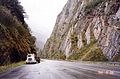 The highway in Keystone Canyon, just north of Valdez
 -
 Horsetail falls, one of many waterfalls visible as the highway traverses Keystone Canyon
 -
 A buried crossing of the highway by the oil pipeline.
 -
 Worthington Glacier seen from the highway


References
- ISBN 0-06-050306-8.
- ^ Federal Highway Administration, National Highway System Viewer Archived 2007-08-27 at the Wayback Machine. Retrieved August 2007.
- Alaska Department of Transportation and Public Facilities, Dwight D. Eisenhower Interstate Routes Archived 2009-07-27 at the Wayback Machine, April 2006
External links
KML is from Wikidata
![]() Media related to Richardson Highway at Wikimedia Commons
Media related to Richardson Highway at Wikimedia Commons
- Evolution of the Richardson Highway - ExploreNorth
- A journey down the Richardson Highway Archived 2011-07-19 at the Wayback Machine; archive Archived 2011-07-19 at the Wayback Machine from archive.org
| Authority control databases: National |
|---|