
List of Alaska Routes
    Shields used for Alaska Routes | |
| Highway names | |
|---|---|
| Interstates | Interstate A-n (A-n) (unsigned) |
| State | Alaska Route n (AK-n) or Route n |
| System links | |
Alaska Routes are both numbered and named. There have been only twelve state highway numbers issued (1 through 11 and 98), and the numbering often has no obvious pattern. For example,
Fairbanks. The Klondike Highway, built in 1978, was unnumbered until 1998, when it was given its designation during the centennial of the Klondike Gold Rush
. However, many Alaskan highways of greater length than the Klondike Highway remain unnumbered.
Mileposts
, frequently used for road markers and official addressing in rural areas, are also more commonly reckoned by landmark names.
Within Alaska, roads are almost invariably referred to by name or general destination, and not by number(s).[citation needed]
Numbered routes often span multiple highway names. For example,
Interstate A3
(A-3).
Highways
U.S. Highways
.svg)
The Alaskan portion of the
topographic maps, mostly published during the 1950s, do bear the US-97 highway shield along or near portions of the current AK-2.[1]
Alaska numbered highways
Alaska named highways
Highways listed below are not signed as numbered state routes.
| Number | Length (mi) | Length (km) | Southern or western terminus | Northern or eastern terminus | Formed | Removed | Notes | |
|---|---|---|---|---|---|---|---|---|
| Alaska Peninsula Highway | — | — | Naknek |
King Salmon | — | — | ||
| Chena Hot Springs Road | — | — | Old Steese Highway north of Fairbanks | Chena Hot Springs | — | — | ||
| Denali Park Road | — | — | Mile 237 (km 382) Denali National Park ) |
Kantishna | — | — | ||
| Douglas Highway | — | — | Douglas Island | Douglas Island | — | — | ||
| Hope Highway | 17.861 | 28.744 | AK-1 (Seward Highway) near Hope | Porcupine Campgrounds in Hope | c. 1928 | current | Forest Highway 14 inside Chugach National Forest | |
| Johansen Expressway | 4.2 | 6.8 | University Avenue in College | Steese Expressway) in Fairbanks
|
— | — | Only highway in Alaska to have exit numbers | |
| Kenai Spur Highway | 38.787 | 62.422 | AK-1 (Sterling Highway) in Soldotna | Bay Beach Road in Nikiski | c. 1951 | current | On the Kenai Peninsula | |
| Minnesota Drive Expressway | 7.560 | 12.167 | Old Seward Highway in Anchorage |
West 15th Avenue in Anchorage | c. 1950 | current | ||
| Nome–Council Highway | 71.970 | 115.824 | Nome Bypass Road / Front Street in Nome | Dead end at Niukluk River in Council | 1906 | current | ||
| Nome–Taylor Highway | — | — | Nome | Taylor | — | — | ||
| Nome–Teller Highway | 72 | 116 | Nome | Teller | — | — | Also called the Bob Blodgett Highway | |
| Palmer–Wasilla Highway | — | — | Palmer | Wasilla | — | — | ||
| Portage Glacier Highway | 11.59 | 18.65 | Portage |
Marine Highway in Whittier | 2000 | current | ||
Salmon River Road
|
11.710 | 18.845 | Wharf near Canada–United States border in Hyder, Alaska | Canada–United States border near Premier, British Columbia (Granduc Road) | — | — | Known as NFD 88 Road inside Tongass National Forest | |
| Top of the World Highway | 79 | 127 | AK-5 (Taylor Highway) near Jack Wade | Hwy 9 at the Canada–United States border
|
c. 1955 | current | ||
| Zimovia Highway | 14 | 23 | Wrangell | McCormick Creek Road in Wrangell | — | — | ||
Marine Highway system
The
All-American Road on September 22, 2005.[4]
The system is divided into different regions of service: Southeast, Cross-Gulf, Prince William Sound, South-Central, and Southwest.[5][6][7]
Gallery
-
 The Glenn Highway, eastbound near Glennallen, is part of Interstate A1.
 -
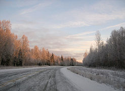
 An interchange between theFairbanks.
 -
 The Sterling Highway, westbound near Homer, is part of Interstate A3.
 -
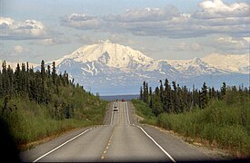
 The George Parks Highway, which comprises the entirety of Interstate A4.
 -
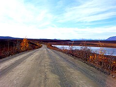 The Denali Highway has only 23 miles (37 km) of pavement, the remaining 123 miles (198 km) is gravel. The road is closed in the winter months.
 -
 The Sterling Highway is a typical example of what is considered a highway in Alaska; four lane restricted-access routes are not used outside of the largest cities.
 -
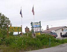 Anchor Point claims the distinction of being the most westerly point on the contiguous highway system in North America.
 -
 Alaska Peninsula Highway approaching "downtown" Naknek.


See also
References
- ^ "History". Highway 97 in British Columbia, Washington, Oregon, & California. Summit Solutions Ltd. 2011. Retrieved September 17, 2018.
- U.S. Congress.
- ^ "New 2002 National Scenic Byways". Federal Highway Administration.
- ^ "New 2005 All-American Roads". Federal Highway Administration.
- Alaska Marine Highway System.
- Alaska Marine Highway System.
- Alaska Marine Highway System.
External links
- "Map of Alaska state highways and numbers" (PDF). from the Alaska Department of Transportation & Public Facilities