
Rio Grande rift

The Rio Grande rift is a north-trending continental rift zone. It separates the Colorado Plateau in the west from the interior of the North American craton on the east.[1] The rift extends from central Colorado in the north to the state of Chihuahua, Mexico, in the south.[2] The rift zone consists of four basins that have an average width of 50 kilometres (31 mi).[1] The rift can be observed on location at Rio Grande National Forest, White Sands National Park, Santa Fe National Forest, and Cibola National Forest, among other locations.
The Rio Grande rift has been an important site for humans for a long time, because it provides a north–south route that follows a major river. The Rio Grande follows the course of the rift from southern Colorado to El Paso, where it turns southeast and flows toward the Gulf of Mexico. Important cities, including Albuquerque, Santa Fe, Taos, Española, Las Cruces, El Paso, and Ciudad Juárez, lie within the rift.
Geology
The Rio Grande rift represents the easternmost manifestation of widespread extension in the western U.S. during the past 35 million years. The rift consists of three major basins and many smaller basins, less than 100 square kilometres (39 sq mi). The three major basins (from northernmost to southernmost) are the
Basin size generally decreases to the north in the rift, though the Española covers approximately 120 kilometres (75 mi) north–south and 40 kilometres (25 mi) east–west, and the San Luis is roughly 120 by 80 kilometres (75 by 50 mi). These basins may contain smaller units within them, such as the


In cross-section, the geometry of the basins within the rift are asymmetrical half-grabens, with major fault boundaries on one side and a downward hinge on the other. Which side of the basin has the major fault or the hinge alternates along the rift. The alternation between these half-grabens occurs along transfer faults, which trend across the rift to connect the major basin-bounding faults and occur between basins or, in places, within basins. The Precambrian basement changes relief sharply in this area, from 8,700 metres (28,500 ft) below sea level at the bottom of the Albuquerque basin to 3,300 metres (10,800 ft) above sea level in the nearby Sandia Mountains, which flanks the Albuquerque basin to the east. Flanking mountains are generally taller along the east side of the rift (although some of this relief may be Laramide in origin).[1] The thickness of the crust increases to the north beneath the rift, where it may be as much as 5 kilometres (3.1 mi) thicker than it is in the south. The crustal thickness underneath the rift is on average 30–35 kilometres (19–22 mi), thinner by 10–15 kilometres (6.2–9.3 mi) than the Colorado Plateau on the west and the Great Plains to the east.[6]

Formation of the rift began with significant deformation and faulting with offsets of many kilometers starting about 35 Ma.
The sedimentary fill of the basins consists largely of
The Rio Grande rift is intersected in northern New Mexico by the NE-SW trending
The youngest eruptions in the rift region are in the
-
 A generalized cross section of the Rio Grande Rift, showing lithospheric and asthenospheric structure. Note the magma lenses and volcanics caused by the welling up of the asthenosphere into the crust, and the thinning of the lithosphere[12]
 -
![Deep seismic image of the Rio Grande rift compiled from the seismic transect shown in the previous figure, showing inferred mantle flow and imaged crust-mantle (Moho) topography (after Wilson et al.)(2005).[8]\](//upload.wikimedia.org/wikipedia/en/thumb/3/39/RioGrande_Rift_RISTRA_Seismic_Image.jpg/218px-RioGrande_Rift_RISTRA_Seismic_Image.jpg)
-
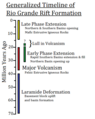 A brief timeline showing extension and volcanism in the Rio Grande rift area. The end of the Laramide orogeny was followed by volcanism and then extension. Changes in lava chemistry are also found, resulting from changes in magmatic sources.[22]

![Deep seismic image of the Rio Grande rift compiled from the seismic transect shown in the previous figure, showing inferred mantle flow and imaged crust-mantle (Moho) topography (after Wilson et al.)(2005).[8]\](/File:RioGrande_Rift_RISTRA_Seismic_Image.jpg)

Geologic history

The Rio Grande rift's
One theory is that the Colorado Plateau acts as a semi-independent microplate[29] and one way of explaining the creation of the Rio Grande rift is by the simple rotation of the Colorado Plateau 1-1.5° in a clockwise direction relative to the North American craton.[1] Other explanations that have been offered are that the extension is driven by mantle forces, such as large-scale mantle upwelling[30] or small-scale mantle convection at the edge of the stable craton;[31] collapse of over-thickened continental crust;[32] initiation of transform faulting along the western margin of the North American plate;[33] or detachment of a fragment of the Farallon plate beneath the Rio Grande region that enhanced asthenospheric upwelling in the slab window.[34]
See also
- Caja del Rio
- Geologic timeline of Western North America
- Lucero volcanic field
- Pajarito Plateau
- Potrillo volcanic field
- Rio Grande Trail
References
- ^ ISBN 0-8137-2291-8.
- ^ ISBN 0-8137-2291-8.
- ^ ISBN 0-8137-2291-8.
- doi:10.2113/34.1.121.
- ^ ISBN 0-8137-2291-8.
- .
- .
- ^ S2CID 4387908.
- ^ Fleck, John (24 February 2005). "Study Sheds Light on 30 Million Years of Rio Grande Valley Stretching". Albuquerque Journal.
- ^ Hill, Karl (25 February 2005). "The Rio Grande Rift: a continent "stretched like taffy"". NMSU News Release.
- .
- ^ a b Baldridge, W.; Olsen, K.; Callender, J. (1984). "Rio Grande Rift: Problems and Perspectives". New Mexico Geological Society Guidebook, 35th field conference. pp. 1–11.
- .
- .
- ^ Aber, James S. "Rio Grande Rift". GO 568 Structural Geology. Archived from the original on 29 January 2006. Retrieved 8 February 2006.
- ^ Veatch, Steven Wade (20 March 1998). "The Rio Grande Rift". Archived from the original on 20 December 2005. Retrieved 8 February 2006.
- .
- .
- .
- ^ "Socorro Magma Body". Archived from the original on 15 June 2010.
- . (Doi fails redirect.)
- ^ Morgan, P.; Golombek, M. (1984). "Factors controlling the phases and styles of extension in the northern Rio Grande rift". New Mexico Geological Society Guidebook, 35th field conference. pp. 13–20.
- ^ Seager, W.R.; Mack, G.H. (1986). "Memoir 41: Laramide Paleotectonics in southern New Mexico". Paleotectonics and Sedimentation in the Rocky Mountain Region: Tulsa, Oklahoma. 155. American Association of Petroleum Geologists: 669–685.
- ^ Chapin, C.E.; Cather, S.M. "Eocene tectonics and sedimentation in the Colorado Plateau-Rocky Mountain area". Arizona Geological Digest. 4: 173–198.
- .
- ^ .
- .
- .
- .
- .
- .
- .
- S2CID 129169733.
- doi:10.1130/B31223.1.