
Rochester, Vermont
Rochester, Vermont | ||
|---|---|---|
Town | ||
FIPS code 50-60100[1] | | |
| GNIS feature ID | 1462188[2] | |
| Website | rochestervermont | |
Rochester is a town in
.Set on the edge of the
History
Rochester was granted in 1780, chartered in 1781 to Dudley Chase, Asa Whitcomb and 63 others, then organized in 1788. It was first settled in the winter of 1781–1782 by David Currier and his family.[4] Rochester's boundaries expanded through annexation of part of Pittsfield town in 1806, annexation of an additional area from Pittsfield town plus a part of Braintree town in 1824, a part of Hancock town in 1834, and finally an annexation of part of Goshen town in 1847.[5]
The surface of the town is mountainous and broken, but the intervales along the
Rochester was one of thirteen Vermont towns isolated by flooding caused by Hurricane Irene in 2011.[6]
In 2018, Rochester High School and Middle School closed due to Act 46. The school had been in Rochester since 1886 and the current building had been used since 1974.
-
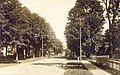 Main Street in 1912
 -
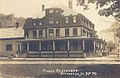 Pierce residence c. 1915
 -
 Street scene c. 1915
 -
 The village, early 1900s


Geography
According to the United States Census Bureau, the town has a total area of 57.4 square miles (148.6 km2), of which 57.1 square miles (147.8 km2) is land and 0.31 square miles (0.8 km2), or 0.53%, is water.[7] Rochester is drained by the White River.
The town is crossed by Vermont Route 73 and Vermont Route 100.
Climate
Rochester has a humid continental climate (Köppen Dfb).
| Climate data for Rochester, Vermont (1991–2020 normals, extremes 1964–2020) | |||||||||||||
|---|---|---|---|---|---|---|---|---|---|---|---|---|---|
| Month | Jan | Feb | Mar | Apr | May | Jun | Jul | Aug | Sep | Oct | Nov | Dec | Year |
| Record high °F (°C) | 64 (18) |
70 (21) |
82 (28) |
91 (33) |
92 (33) |
95 (35) |
95 (35) |
98 (37) |
95 (35) |
84 (29) |
75 (24) |
68 (20) |
98 (37) |
| Mean daily maximum °F (°C) | 29.2 (−1.6) |
32.1 (0.1) |
40.6 (4.8) |
54.1 (12.3) |
67.3 (19.6) |
75.1 (23.9) |
79.4 (26.3) |
78.3 (25.7) |
71.7 (22.1) |
58.5 (14.7) |
46.4 (8.0) |
34.5 (1.4) |
55.6 (13.1) |
| Daily mean °F (°C) | 18.9 (−7.3) |
20.5 (−6.4) |
29.0 (−1.7) |
41.9 (5.5) |
53.9 (12.2) |
62.5 (16.9) |
67.2 (19.6) |
66.0 (18.9) |
59.1 (15.1) |
47.1 (8.4) |
36.6 (2.6) |
25.5 (−3.6) |
44.0 (6.7) |
| Mean daily minimum °F (°C) | 8.7 (−12.9) |
8.8 (−12.9) |
17.3 (−8.2) |
29.7 (−1.3) |
40.5 (4.7) |
49.8 (9.9) |
55.0 (12.8) |
53.8 (12.1) |
46.6 (8.1) |
35.8 (2.1) |
26.8 (−2.9) |
16.4 (−8.7) |
32.4 (0.2) |
| Record low °F (°C) | −32 (−36) |
−28 (−33) |
−21 (−29) |
1 (−17) |
21 (−6) |
30 (−1) |
35 (2) |
33 (1) |
23 (−5) |
9 (−13) |
−2 (−19) |
−30 (−34) |
−32 (−36) |
| Average precipitation inches (mm) | 3.49 (89) |
2.82 (72) |
3.38 (86) |
3.81 (97) |
3.85 (98) |
5.24 (133) |
5.09 (129) |
4.45 (113) |
3.93 (100) |
4.96 (126) |
3.73 (95) |
4.12 (105) |
48.87 (1,241) |
| Average snowfall inches (cm) | 18.4 (47) |
17.4 (44) |
15.5 (39) |
3.6 (9.1) |
0.0 (0.0) |
0.0 (0.0) |
0.0 (0.0) |
0.0 (0.0) |
0.0 (0.0) |
0.5 (1.3) |
2.8 (7.1) |
17.3 (44) |
75.5 (192) |
| Average precipitation days (≥ 0.01 in) | 8.7 | 8.1 | 8.5 | 10.7 | 13.1 | 14.3 | 12.9 | 11.0 | 10.0 | 12.9 | 9.4 | 10.5 | 130.1 |
| Average snowy days (≥ 0.1 in) | 7.0 | 6.5 | 4.9 | 1.2 | 0.0 | 0.0 | 0.0 | 0.0 | 0.0 | 0.4 | 1.7 | 7.0 | 28.7 |
| Source: NOAA[8][9] | |||||||||||||
Demographics
| Census | Pop. | Note | %± |
|---|---|---|---|
| 1790 | 215 | — | |
| 1800 | 524 | 143.7% | |
| 1810 | 911 | 73.9% | |
| 1820 | 1,148 | 26.0% | |
| 1830 | 1,392 | 21.3% | |
| 1840 | 1,396 | 0.3% | |
| 1850 | 1,493 | 6.9% | |
| 1860 | 1,507 | 0.9% | |
| 1870 | 1,444 | −4.2% | |
| 1880 | 1,362 | −5.7% | |
| 1890 | 1,257 | −7.7% | |
| 1900 | 1,250 | −0.6% | |
| 1910 | 1,317 | 5.4% | |
| 1920 | 1,397 | 6.1% | |
| 1930 | 1,285 | −8.0% | |
| 1940 | 1,129 | −12.1% | |
| 1950 | 937 | −17.0% | |
| 1960 | 879 | −6.2% | |
| 1970 | 884 | 0.6% | |
| 1980 | 1,054 | 19.2% | |
| 1990 | 1,181 | 12.0% | |
| 2000 | 1,171 | −0.8% | |
| 2010 | 1,139 | −2.7% | |
| 2020 | 1,099 | −3.5% | |
| U.S. Decennial Census[10] | |||
As of the

There were 511 households, out of which 28.2% had children under the age of 18 living with them, 52.4% were couples living together and joined in either
In the town, the population was spread out, with 22.1% under the age of 18, 5.0% from 18 to 24, 26.3% from 25 to 44, 28.8% from 45 to 64, and 17.8% who were 65 years of age or older. The median age was 43 years. For every 100 females, there were 93.2 males. For every 100 females age 18 and over, there were 96.6 males.
The median income for a household in the town was $35,820, and the median income for a family was $41,131. Males had a median income of $30,395 versus $21,964 for females. The
Site of interest
Notable people
- Barbara Fiske Calhoun, World War II cartoonist, artist and co-founder of Quarry Hill Creative Center
- William Wildman Campbell, US congressman from Ohio
- Irving Fiske, playwright and co-founder of Quarry Hill Creative Center in Rochester
- Robert H. Gardner, Academy Award nominated filmmaker, resides in Rochester[11]
- Jeremiah Ingalls, early American composer
- William B. Martin, Iowa Secretary of State
- Edna Chaffee Noble, elocutionist
- governor of Indiana
Climate
This
References
- ^ a b "U.S. Census website". United States Census Bureau. Retrieved January 31, 2008.
- ^ "US Board on Geographic Names". United States Geological Survey. October 25, 2007. Retrieved January 31, 2008.
- ^ "Census - Geography Profile - Rochester town, Windsor County, Vermont". United States Census Bureau. Retrieved October 28, 2021.
- ^ a b Austin J. Coolidge & John B. Mansfield, A History and Description of New England; Boston, Massachusetts 1859
- ^ Vermont Secretary of State, State Papers of Vermont, Volume 1: Index to the Papers of the Surveyors-General (page 124)
- ^ Floodwaters From Storm Isolate 13 Vermont Towns, The New York Times
- ^ "Geographic Identifiers: 2010 Demographic Profile Data (G001): Rochester town, Windsor County, Vermont". United States Census Bureau. Retrieved July 31, 2012.
- ^ "NOWData - NOAA Online Weather Data". National Oceanic and Atmospheric Administration. Retrieved December 17, 2023.
- ^ "Summary of Monthly Normals 1991-2020". National Oceanic and Atmospheric Administration. Retrieved December 17, 2023.
- ^ "U.S. Decennial Census". United States Census Bureau. Retrieved May 16, 2015.
- ^ "Documentary Film Director 'Had a Good Feeling' About Vt. - the White River Valley Herald". May 7, 2015.
- ^ Climate Summary for Rochester, Vermont
External links
- Town of Rochester official website
- Rochester Public Library
- Rochester Historical Society
- Rochester School District
- Rochester at Virtual Vermont
- Historic Pierce Hall
| Towns | ||
|---|---|---|
Villages | ||
| CDPs | ||
| Other communities | ||
| ||
| International | |
|---|---|
| National | |