
Rothenfels
Rothenfels | ||
|---|---|---|
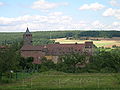
 Rothenfels from the northeast across the Main, Rothenfels Castle in the background | ||
 Coat of arms | ||
Location of Rothenfels within Main-Spessart district | ||
Municipal assoc. Marktheidenfeld | | |
| Government | ||
| • Mayor (2020–26) | Michael Gram[1] | |
| Area | ||
| • Total | 12.07 km2 (4.66 sq mi) | |
| Elevation | 154 m (505 ft) | |
| Population (2022-12-31)[2] | ||
| • Total | 1,012 | |
| • Density | 84/km2 (220/sq mi) | |
| Time zone | UTC+01:00 (CET) | |
| • Summer (DST) | UTC+02:00 (CEST) | |
| Postal codes | 97851 | |
| Dialling codes | 09393 | |
| Vehicle registration | MSP | |
| Website | www.rothenfels.de | |
Rothenfels is a town in the Main-Spessart district in the Regierungsbezirk of Lower Franconia (Unterfranken) in Bavaria, Germany and a member of the Verwaltungsgemeinschaft (municipal association) of Marktheidenfeld. With a population of just around 1,000 it is said to be Bavaria’s smallest town.
Geography
Location
Rothenfels lies on the Main’s right bank between Lohr and Marktheidenfeld, 5 km north of Marktheidenfeld, and 33 km east of Aschaffenburg. Squeezed as it is between the river and a bluff, the town consists of little more than a main street. Since 2006, the Maindamm, previously part of the railway line Lohr-Wertheim has been used as a town bypass.
Neighbouring communities
From the north, clockwise: Neustadt am Main, Marktheidenfeld, Hafenlohr, Fürstlich Löwensteinscher Park (gemeindefreies Gebiet).
Subdivisions
Rothenfels has two
History
Marquardt II von Grumbach,

The settlements, which arose under Rothenfels Castle’s protection, were the later town in the valley and the farming estate that later became Bergrothenfels. When, in 1243, Albert II, the last of the Gumbach family died, town and castle came to the
In the 16th and early 17th century Rothenfels faced hardships, e.g. during the
During
In 1881, the Lohr–Wertheim line was opened, connecting the town to the railway system.[3]: 41
After
Bergrothenfels was separated administratively from Rothenfels in the 19th century, only to be reamalgamated in the 1971 Gebietsreform.[3]: 41
Governance
Mayor
From 1996 to 2014 Rosemarie Richartz (Stadtrat 96) was the mayor of Rothenfels. Since 2014 Michael Gram (Unabhängige Bürger/Freie Bürger/SPD) is the new mayor.[4]
Coat of arms
The town’s arms might be described thus: Or in base water argent, issuant therefrom three crags gules, in chief the letter R of the same.
The town’s oldest known seal, carved in the late 16th century and known from a 1619 imprint, only showed the uppercase R. The same image is shown in a roll of arms from 1544, wherein the R is shown in red on a silver field. Shown on town and council seals from 1710 is a castle on crags, which are surmounted by the uppercase R (that is, the R is on the crags, not over them), possibly canting for the town’s name, which means "Stronghold in Red Bunter". Since the early 19th century, all examples of the town’s seal show the current composition. The arms were affirmed in 1836.[5]
Attractions
Aside from its late-16th century town hall and the former Spital (1578-97), the town features some historic timber-frame houses from the 16th and 17th centuries.[3]: 40
The parish church was originally built in the 15th century, serving both Rothenfels and Bergrothenfels. It was renovated in 1610/1. The Baroque tower dates from 1750.[3]: 40
On the hill above the town stands Rothenfels Castle (Burg Rothenfels). Rothenfels Castle is associated with the
Gallery
-
 Main street
 -
 Church
 -
 Rothenfels Castle


References
- Bayerisches Landesamt für Statistik, 15 July 2021.
- ^ Genesis Online-Datenbank des Bayerischen Landesamtes für Statistik Tabelle 12411-003r Fortschreibung des Bevölkerungsstandes: Gemeinden, Stichtag (Einwohnerzahlen auf Grundlage des Zensus 2011) (Hilfe dazu).
- ^ ISBN 3-8313-1075-0.
- ^ "Bürgermeisterwahl in Rothenfels: Gram neuer Bürgermeister". 16 March 2014.
- ^ Description and explanation of Rothenfels’s arms
External links
- Town’s official webpage (in German)
- Rothenfels Castle (in German)

| International | |
|---|---|
| National | |
| Other | |