
Samara Arboretum
The Samara Arboretum (French Arboretum de Samara) is an arboretum and botanical garden located in the Samara historical park in La Chaussée-Tirancourt, Somme, Picardy, France. It is open daily in the warmer months; an admission fee is charged.
Samara is a regional development project that recreates ancient civilization and habitation based on local archaeology, from paleolithic to Gallo-Roman times, including reconstructions of homes and other buildings set within the area's marshes. The park includes an arboretum (100 varieties of trees), small botanical garden (500 plant varieties), ethnobotanical garden representing neolithic cultivation, and nature trail.
Gallery
-
 Gallic house, Iron Age
 -
 Gallic house, Iron Age
 -
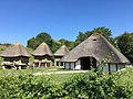 Gallic house and granaries, c. 300 BC
 -
 Gallic house, Iron Age
 -
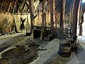
 Gallic house interior
 -
 Gallic house interior
 -
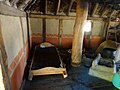 Gallic house interior
 -
 Gallic village, Iron Age
 -
 Celtic house, Iron Age
 -
 Celtic house interior, Iron Age
 -
 Celtic funerary wagon
 -
 Gallic reconstruction
 -
 Gallic warrior
 -
 Iron Age agricultural equipment
 -
 Gallic village
 -
 Bronze Age buildings
 -
 Bronze Age interior
 -
 Neolithic house
 -
 Neolithic clothing
 -
 Neolithic loom
 -
 Neolithic interior
 -
 Neolithic interior
 -
 Paleolithic hut


,_parc_Samara,_zone_des_animations_et_reconstitutions_-_la_ferme_gauloise_(vers_300_av._J.-C.)_1.jpg)
,_parc_Samara,_zone_des_animations_et_reconstitutions_-_la_ferme_gauloise_(vers_300_av._J.-C.)_3.jpg)
,_parc_Samara,_zone_des_animations_et_reconstitutions_-_la_ferme_gauloise_(vers_300_av._J.-C.)_5.jpg)
,_parc_Samara,_zone_des_animations_et_reconstitutions_-_la_ferme_gauloise_(vers_300_av._J.-C.)_7.jpg)
,_parc_Samara,_zone_des_animations_et_reconstitutions_-_atelier_du_travail_du_verre,_ferme_gauloise_(en_haut).jpg)

,_parc_Samara,_pavillon_d%27exposition_-_int%C3%A9rieur_gaulois_2.jpg)
,_parc_Samara,_zone_des_animations_et_reconstitutions_-_atelier_du_travail_du_bois_5.jpg)
,_parc_Samara,_pavillon_d%27exposition_-_int%C3%A9rieur_gaulois_3.jpg)

,_parc_Samara,_pavillon_d%27exposition_-_l%27antiquit%C3%A9,_ustensiles_de_l%27agriculteur.jpg)
,_parc_Samara,_zone_des_animations_et_reconstitutions_-_poterie_1.jpg)
,_parc_Samara,_zone_des_animations_et_reconstitutions_-_maisons_de_l%27%C3%A2ge_du_Bronze_(vers_700_av._J.-C.)_2.jpg)
,_parc_Samara,_pavillon_d%27exposition_-_l%27%C3%A2ge_du_bronze,_travail_des_m%C3%A9taux_et_vannerie_1.jpg)
,_parc_Samara,_zone_des_animations_et_reconstitutions_-_maison_du_N%C3%A9olithique_ancien_3.jpg)
,_parc_Samara,_pavillon_d%27exposition_-_l%27habit_au_n%C3%A9olithique.jpg)
,_parc_Samara,_pavillon_d%27exposition_-_un_m%C3%A9tier_%C3%A0_tisser_au_n%C3%A9olithique.jpg)
,_parc_Samara,_zone_des_animations_et_reconstitutions_-_maison_du_N%C3%A9olithique_ancien_10.jpg)
,_parc_Samara,_zone_des_animations_et_reconstitutions_-_maison_du_N%C3%A9olithique_ancien_5.jpg)
,_parc_Samara,_zone_des_animations_et_reconstitutions_-_campement_du_Pal%C3%A9olithique_6.jpg)
See also
- List of botanical gardens in France
- Hallstatt culture
- La Tène culture
- Bronze Age Europe
- Neolithic Europe
References
- Samara
- James Stephen Bromwich, The Roman Remains of Northern and Eastern France, Routledge, 2003, page 73. ISBN 978-0-415-13994-6.
49°56′47″N 2°10′43″E / 49.94639°N 2.17861°E
This article related to a garden in France is a stub. You can help Wikipedia by expanding it. |