
Sambre
| Sambre/Samber | |
|---|---|
 The Sambre in the centre of Namur | |
 | |
| Location | |
| Countries | Belgium and France |
| Physical characteristics | |
| Source | |
| • location | Picardy |
| • elevation | 199 m (653 ft) |
| Mouth | |
• location | Meuse at Namur |
• coordinates | 50°27′43″N 4°52′15″E / 50.46194°N 4.87083°E |
| Length | 193 km (120 mi) |
| Basin size | 2,740 square kilometres (1,060 sq mi) |
| Basin features | |
| Progression | Meuse→ North Sea |
The Sambre (French: [sɑ̃bʁ]; Dutch: Samber [ˈsɑmbər] ⓘ) is a river in northern France and in Wallonia, Belgium. It is a left-bank tributary of the Meuse, which it joins in the Wallonian capital Namur.
The source of the Sambre is near
The navigable waterway is managed in France by Voies Navigables de France and in Belgium by the Service Public Wallon - Direction générale opérationnelle de la Mobilité et des Voies hydrauliques (Operational Directorate of Mobility and Inland Waterways)[2]
Course
The Sambre flows through the following départements of France, provinces of Belgium and towns:
- Aisne (F): Barzy-en-Thiérache
- Nord (F): Landrecies, Aulnoye-Aymeries, Hautmont, Maubeuge
- Namur
-
 The Sambre at Aulne Abbey in Belgium
 -
 The Sambre at Flawinne (Namur)
 -
 The Sambre at Ham-sur-Sambre
 -
 The Sambre at Moustier-sur-Sambre
 -
 A barge on the Sambre in Namur
 -
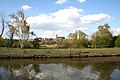
 The Sambre in Namur
 -
 The canalised Sambre running through the centre of Charleroi


.jpg)
.jpg)

Main tributaries
Events
- On 24 February 1912, Regina Magritte, the mother of the famous surrealist painter Réné Magritte, drowned herself in this river at Châtelet.[6]
Battles
The 19th-century theory that the Sambre was the location of Julius Caesar's battle against a Belgic confederation (57 BC), was discarded a long time ago,[7] but is still repeated.
Three important battles were fought in Fleurus, a suburb of Charleroi on the north bank of the Sambre: the Thirty Years' War Battle of Fleurus (1622), the Nine Years' War Battle of Fleurus (1690), and the crucial 26 June 1794 Battle of Fleurus (1794), the most significant battle of the Flanders Campaign in the Low Countries during the French Revolutionary Wars. The last was fought on both banks of the river, culminating a campaign that had involved multiple crossings and re-crossings of the river.
Heavy fighting occurred along the river during World War I, especially at the siege of Namur in 1914 (Battle of Charleroi) and in the last month of the war Battle of the Sambre (1918).
References
- ISBN 978-1-846230-14-1.
- ISBN 979-10-94429-00-6.
- ^ ., see tab "Affluents"
- ^ a b c d e f g h i j k l m "Contrats de rivière en Wallonie - Sambre". Environnement.wallonie.be. Retrieved 25 March 2018.
- ^ "Le Ruisseau "le Piéton" - Piéton, Village du Hainaut". Pieton.eu. Retrieved 25 March 2018.
- PMID 17679631.
- ^ Pierre Turquin ("La Bataille de la Selle (du Sabis) en l' An 57 avant J.-C." in Les Études Classiques 23/2 (1955), 113-156) has proved beyond reasonable doubt that the battle was fought at the River Selle, west of modern Saulzoir.
External links
- River Sambre and Canal de la Sambre à l'Oise with maps and details of places, moorings and facilities for boats, by the author of Inland Waterways of France, Imray
- Navigation details for 80 French rivers and canals (French waterways website section)