
Santiago Province, Chile
Santiago Province
Provincia de Santiago | |
|---|---|
UTC−3 (CLST) | |
| Area code | 56 + 2 |
Santiago Province (
Administration
As a province, Santiago is a second-level administrative division of Chile. As its capital is also the regional capital, the duties of the provincial delegate are instead carried out by the regional delegate of the Santiago Metropolitan Region who is appointed by the president.
Communes
The province comprises 32 communes (Spanish: comunas), each governed by a municipality consisting of an alcalde and municipal council.
| Commune | Area (km2)[1] | 2002[1] population |
Pop. density (km2) | Municipality website |
|---|---|---|---|---|
| Santiago (Capital) | 22.4 | 200,792 | 8,963.9 | link |
| Vitacura | 28.3 | 81,499 | 2,879.8 | link |
| San Ramón | 6.5 | 94,906 | 14,600.9 | link |
| San Miguel | 9.5 | 78,872 | 8,302.3 | link |
San Joaquín |
9.7 | 97,625 | 10,064.4 | link |
| Renca | 24.2 | 133,518 | 5,517.3 | link |
| Recoleta | 16.2 | 148,220 | 9,149.4 | link |
| Quinta Normal | 12.4 | 104,012 | 8,388.1 | link |
| Quilicura | 57.5 | 126,518 | 2,200.3 | link |
| Pudahuel | 197.4 | 195,653 | 991.1 | link |
| Providencia | 14.4 | 120,874 | 8,394.0 | link |
| Peñalolén | 54.2 | 216,060 | 3,986.3 | link |
| Pedro Aguirre Cerda | 9.7 | 114,560 | 11,810.3 | link |
| Ñuñoa | 16.9 | 163,511 | 9,675.2 | link |
| Maipú | 133.0 | 468,390 | 3,521.7 | link |
| Macul | 12.9 | 112,535 | 8,723.6 | link |
| Lo Prado | 6.7 | 104,316 | 15,569.6 | link |
| Lo Espejo | 7.2 | 112,800 | 15,666.7 | link |
| Lo Barnechea | 1,023.7 | 74,749 | 73.0 | link |
| Las Condes | 99.4 | 249,893 | 2,514.0 | link |
| La Reina | 23.4 | 96,762 | 4,135.1 | link |
| La Pintana | 30.6 | 190,085 | 6,211.9 | link |
| La Granja | 10.1 | 132,520 | 13,120.8 | link |
| La Florida | 70.8 | 365,674 | 5,164.9 | link |
La Cisterna |
10.0 | 85,118 | 8,511.8 | link |
| Independencia | 7.4 | 65,479 | 8,848.5 | link |
| Huechuraba | 44.8 | 74,070 | 1,653.3 | link |
| Estación Central | 14.1 | 130,394 | 9,247.8 | link |
| El Bosque | 14.1 | 175,594 | 12,453.5 | link |
| Conchalí | 70.7 | 133,256 | 1,884.8 | link |
| Cerro Navia | 11.1 | 148,312 | 13,361.4 | link |
| Cerrillos | 21.0 | 71,906 | 3,424.1 | link |
Climate and natural features

The climate of the Santiago Province, and generally of the
The annual median precipitation reaches 367 mm on average. The annual median temperature comes out to 13.5 °C, with a median high of 21 °C and a median low of 6 °C.
Most of the province is made up of an extremely fertile, level prairie that the locals call la Depresión intermedia (
There is some occurrence of the
Demographics
History
Before the Iberian conquest, the central zone of Chile was sparsely inhabited by an indigenous population of Picunches, the northern branch of the Mapuches. The European occupation had a considerable impact on the native population and culture, which suffered a rapid and profound disintegration. Chief among the reasons was the Spanish Crown's granting of gifts of land to its colonists. In addition, the institution of a system of encomiendas, only abolished by the end of the 18th century, had irreversible consequences. It represented first the appropriation of indigenous ground, and second the practice of Spaniards receiving groups of natives who had to pay tribute. Over time, in the Province, as in the whole country, cultural identity became predominantly European in character, with minor hints of native character, thus setting in motion a process of homogenization of the population.
Population
According to the
The population tends to be concentrated evenly between the heart of the city and the suburbs, due to government promotion of populating urban centers in high-rise buildings by offering state subsidies, thereby avoiding the progressive extension of
Economy

Santiago Province's economic activity produces about 30% of the country's total income; a high number due to both having the capital of the country within its area and to its central location. The "primary" or agricultural sector represents less than 3.5% of the economic activity according to the census, a figure that has remained virtually unchanged during the first few years of the 21st century. The "secondary" or industrial sector contributes 21% of the region's
Transportation and communication
Because Santiago Province includes the city of
- Route 5 (Autopista Central)
The basepoint for numbering the kilometers of the "Central Highway", the Chilean portion of the
This route links Santiago with Valparaíso, Viña del Mar, and the summer resorts and beaches in the fifth region of Valparaíso. In addition, it connects the towns of Casablanca and Curacaví. The toll highway, consisting of two- and three-lane sections of well-maintained pavement, extends for 115 kilometers.
- Route 78 (Autopista del Sol)
The "Highway of the Sun" is a toll road that links Santiago with San Antonio, and from there connects to other coastal towns including Llolleo, Cartagena, El Quisco, and Algarrobo. It also connects to the more central Melipilla, Talagante, El Monte, Padre Hurtado and Peñaflor. Route 78 extends 110 kilometers.
- Route G-21
This 40 kilometer route joins Santiago with the winter resort towns of Farellones and Valle Nevado.
- Route G-25
This route connects Santiago and the province of Puente Alto with Cajón del Maipo. It extends roughly 70 km to its termination in the town of El Volcán.
Roads and railways
Other important highways in Santiago province are its network of Autopistas Urbanas (urban highways). Santiago's first toll roads began to operate near the end of 2004. The tolls for uctronic payment system called Televía or
The main highways in Santiago province are:
The province's
Gallery
-
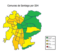 Metropolitan communes by Human Development Index
 -
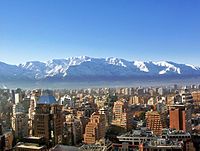 Santiago de Chile
 -
 View of Palacio deLa Moneda
 -
 East Santiago
 -
 East Santiago
 -
 Typical middle-class neighbourhood
 -
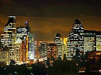 Santiago at night
 -
 View of the region's rural part
 -
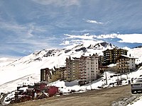 One of the region's ski centres
 -

-

-

-

-
 Polo national team with ex-president Michelle Bachelet after winning Polo's World Cup


Footnotes
- ^ a b c d e f g (in Spanish) Instituto Nacional de Estadísticas
- ^ C. Michael Hogan (2008) Chilean Wine Palm: Jubaea chilensis, GlobalTwitcher.com, ed. Nicklas Stromberg Archived 2012-10-17 at the Wayback Machine
References
- This article draws heavily on the corresponding article in the Spanish-language Wikipedia, which was accessed in the version of 28 November 2005.

| International | |
|---|---|
| National | |