
Sauensiek
Sauensiek | |
|---|---|
Location of Sauensiek within Stade district 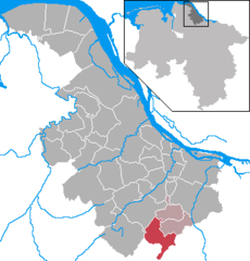 | |
 Sauensiek  Sauensiek | |
| Coordinates: 53°23′N 9°36′E / 53.383°N 9.600°E | |
| Country | Germany |
| State | Lower Saxony |
| District | Stade |
| Municipal assoc. | Apensen |
| Subdivisions | 3 |
| Government | |
| • Mayor | Rolf Suhr (CDU) |
| Area | |
| • Total | 31.37 km2 (12.11 sq mi) |
| Elevation | 36 m (118 ft) |
| Population (2022-12-31)[1] | |
| • Total | 2,576 |
| • Density | 82/km2 (210/sq mi) |
| Time zone | UTC+01:00 (CET) |
| • Summer (DST) | UTC+02:00 (CEST) |
| Postal codes | 21644 |
| Dialling codes | 04169 |
| Vehicle registration | STD |
| Website | www.sauensiek.de |
Sauensiek is a municipality in the district of Stade, Lower Saxony, Germany.
Location
The Litberg, the highest point in the district of Stade, lies within the municipality of Sauensiek. It has a height of 65 metres above sea level and has been designated as a protected area.
History
Sauensiek belonged - as to its government - to the
Duchy of Bremen, which was first ruled in personal union by the Swedish Crown - interrupted by a Danish occupation (1712–1715) - and from 1715 on by the Hanoverian Crown. The Kingdom of Hanover incorporated the Duchy in a real union and the Ducal territory became part of the new Stade Region
, established in 1823.
References
- Landesamt für Statistik Niedersachsen.
- ^ ISBN 978-3-9801919-8-2.

| International | |
|---|---|
| National | |
This Stade (district) location article is a stub. You can help Wikipedia by expanding it. |