
Sawahlunto
Sawahlunto | |
|---|---|
| Other transcription(s) | |
| • Jawi | ساواهلونتو |
 Bukit Asam Office, a notable landamark of Sawahlunto | |
|
UTC+7 (Indonesia Western Time) | |
| Area code | (+62) 754 |
| Climate | Af |
| Website | sawahluntokota.go.id |
Sawahlunto (
Sawahlunto is one of the mining towns in West Sumatra. It was first established as a town in 1882 by the Dutch along with coal mining operations. Coal was discovered in the mid-19th century by Ir. de Greve. It was then suggested to the Dutch that coal should be mined in the area because coal was needed for industry and transportation. After the discovery of coal, the area was frequently visited by geologists. Coal mining was pioneered in the area after the eventual "surrender" of the area to the Dutch in 1876. After the golden period of mining and the closure of the mine sites, Sawahlunto became a ghost town and the population declined. In 2004, the city's policy became to turn Sawahlunto into a tourist city, since when the population has increased. In 2014, 29 percent of its income came from tourism, while only 23 percent came from farming.[5]
The Ombilin coal mining site at Sawahlunto has been listed as a UNESCO World Heritage Site in 2019.[6]
History
Sawahlunto is one of the many towns located in the area of
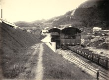
Coal mining had significantly changed the rural landscape of Sawahlunto into an industrial site. During its development in the 19th century, mining companies designed the Sawahlunto mining site into five spatial activities: coal mining industry, commercial and trade areas, residential areas, administrative areas, and health utilities. To support its activities, the Netherlands built several transportation networks such as creating a railway network to transport coal from Sawahlunto to the west coast of Sumatra. The Dutch East Indies also built Emmahaven Port (known as Teluk Bayur) which became a shipping port for coal exports, using steamers SS Sawahlunto and SS Ombilin-Nederland. Meanwhile, in 1887–1892, they began building a train from Pulau Air Padang to Muaro Kalaban and from this station to the Sawahlunto area.[7]
- In 1888 the Nederland Indies initialised many coal mining facilities
- In 1894 train tracks were opened
- In 1898 the first coal mining tunnel was built at Air Dingin, Lembah Segar, but was later closed in 1932 and re-opened again in June 2007.Dutch Indiesgovernment invested 5.5 million [gulden] (the Dutch currency at that time) to build various facilities to manage the coal mining industry Ombilin. This residential area continued to expand to become a small town that consisted mainly of officers and coal miners.
The
In 1918 Sawahlunto was known as
Globally, from 1940 till the end 70s the production of coal by Ombilin declined, and shrank to only tens of thousands of tons per year. Sawahlunto also faced a decline in coal production indicative of the decline in population to only 13,561 inhabitants in 1980. With the increased number of facilities, a change in management, and the application of new technology, the mining industry increased again since the beginning of the 80s. Moreover, production continued to increase even exceeding 1 million tonnes per year in the late 90s. The population in Sawahlunto increased to 15,279 according to the Census in 1990. Even though the population growth rate is only 1.2%, it is still below the annual average population growth rate of
Mining was initiated in the area after Independence. Activities were undertaken by PT Tambang Batubara
Administrative districts
Sawahlunto city consists of four districts (kecamatan), tabulated below with their areas and population totals from the 2010 Census[3] and the 2020 Census,[4] together with the official estimates as of mid-2022.[1] The table also includes the locations of the district administrative centres, the number of administrative villages in each district (totaling 27 rural desa and 10 urban kelurahan), and their postal codes.
| Name of District (kecamatan) |
Area in km2 |
Po'n Census 2010' |
Pop'n Census 2020 |
Pop'n Estimate mid 2022 |
Admin centre |
No. of villages |
Post codes |
|---|---|---|---|---|---|---|---|
| Silungkang | 32.93 | 10,126 | 11,409 | 11,594 | Muaro Kalaban | 5 | 27431-27435 |
| Lembah Segar | 52.58 | 12,145 | 13,352 | 13,503 | Aur Mulyo | 11 (a) | 27411-27419 |
| Barangin | 88.55 | 16,912 | 20,284 | 20,863 | Santua | 10 (b) | 27421-27427 |
| Talawi | 99.39 | 17,682 | 20,093 | 20,452 | Talawi Mudiak | 11 | 27441-27449 |
| Totals | 273.45 | 56,866 | 65,138 | 66,413 | Lembah Segar | 37 |
Notes: (a) includes 6 kelurahan. (b) includes 4 kelurahan.
Geography
Geographically Sawahlunto is located at 033’40" – 043’ 33" South and 100 43’ 13" – 100 50’ 40" East, bounded to the north by
Sawahlunto has a maximum elevation of about 650m above sea level. The landscape is primarily made up of steep hills which act as a hindrance to the development of the town. The old town centre spanned 5.8 km2. Relatively flat lands can be found in the Kecamatan Talawi district. The area that runs from north to south has a relatively steep topography at an angle of elevation of approximately 40%. On the other hand, the northern area is relatively gently sloping. Most developments are located at a height of 100-500m. Development consists of both protected areas (25%) as well as areas set aside for cultivation (73%). This land mainly consists of mixed gardening(34%), thick forest and scrub(19%). 0.2% of the lake was once used for mining.
Climate
Sawahlunto has a tropical rainforest climate (Af) with heavy rainfall year-round.
| Climate data for Sawahlunto | |||||||||||||
|---|---|---|---|---|---|---|---|---|---|---|---|---|---|
| Month | Jan | Feb | Mar | Apr | May | Jun | Jul | Aug | Sep | Oct | Nov | Dec | Year |
| Mean daily maximum °C (°F) | 30.1 (86.2) |
30.7 (87.3) |
30.8 (87.4) |
30.8 (87.4) |
31.2 (88.2) |
30.8 (87.4) |
30.5 (86.9) |
30.5 (86.9) |
30.2 (86.4) |
30.1 (86.2) |
30.1 (86.2) |
29.8 (85.6) |
30.5 (86.8) |
| Daily mean °C (°F) | 25.6 (78.1) |
26.0 (78.8) |
26.1 (79.0) |
26.2 (79.2) |
26.5 (79.7) |
25.9 (78.6) |
25.6 (78.1) |
25.6 (78.1) |
25.7 (78.3) |
25.7 (78.3) |
25.8 (78.4) |
25.5 (77.9) |
25.9 (78.5) |
| Mean daily minimum °C (°F) | 21.2 (70.2) |
21.3 (70.3) |
21.4 (70.5) |
21.7 (71.1) |
21.8 (71.2) |
21.1 (70.0) |
20.8 (69.4) |
20.8 (69.4) |
21.2 (70.2) |
21.4 (70.5) |
21.5 (70.7) |
21.3 (70.3) |
21.3 (70.3) |
| Average rainfall mm (inches) | 262 (10.3) |
183 (7.2) |
238 (9.4) |
279 (11.0) |
194 (7.6) |
132 (5.2) |
100 (3.9) |
129 (5.1) |
172 (6.8) |
237 (9.3) |
256 (10.1) |
259 (10.2) |
2,441 (96.1) |
| Source: Climate-Data.org[10] | |||||||||||||
Demographic
Population
As of the 2020 Census, the total population of Sawahlunto stood at around 65,138, consisting of 32,737 males and 32,371 females.[4]
Their source of income varies from working on farms to mining and service sectors. The economic structure of the people of Sawahlunto is mainly supported by mining. Subsectors consist of agriculture, small industries/handicrafts, and livestock farming.
With the expansion of the district based on government law No.44, 1990 Sawahlunto became known not only for handicrafts, snacks, livestock, and fruits but also as a tourist destination.
Religion

The majority of the population of Sawahlunto City embraces Islam. Most of its adherents are Minangkabau people. Other religions practiced in this city are Christianity, Hinduism, and Confucianism, most of which are adhered to by non-Minangkabau residents. Various places of worship are also found in this city. Apart from being dominated by mosques, there are also two churches in Sawahlunto City, namely the Sawahlunto St. Parish Church. Barbara and HKBP Sawahlunto Church.[11][12]
Ethnicity
The current population of the town of Sawahlunto is dominated by the Minangkabau and Javanese ethnic groups. Other ethnic groups who are also residents are Chinese and Batak. Since Sawahlunto was founded in the 19th century and was established as a coal mining town, the Dutch East Indies government began sending convicts from various prisons in Indonesia to Sawahlunto as forced laborers, around 20,000 convicts were shipped to Sawahlunto. This forced labor is known by the local community as Orang Rantai (Chained People).
Mayors

Mayors who have led the town of Sawahlunto since its inauguration to date are as follows:
- Achmad Nurdin, SH (Term of office 1965 s/d 1971)
- Drs. Shaimoery, SH (Term of office 1971 s/d 1983)
- Drs. Nuraflis Salam (Term of office 1983 s/d 1998)
- Drs. H. Rahmatsjah (Term of office 1998 s/d 1993)
- Drs. H. Subari Sukardi (Term of office 1993 s/d 1998 and Term of office 1998 s/d 2003)
- Ir. H. Amran Nur (Term of office 2003 S/D 2008) and H. Fauzi Hasan (Term of office, representative 2003 S/D 2008)[13]
- Ir. H. Amran Nur (Term of office 2008 S/D 2013) and H. Erizal Ridwan, ST (Term of office, representative 2008 S/D 2013)
- Ali Yusuf, S.Pt. (Term of office 2013 S/D 2018) and Ismed, S.H. (Term of office, representative 2013 S/D 2018)
Recent developments
In 1990 the
Over 100 years, the amount of coal exploited has reached approximately 30 million tonnes with remaining reserves of more than 100 million tonnes. However, the future of the coal mining industry in Ombilin is now unclear due to reserves that can only be exploited internally. Whether or not these reserves will be exploited depends on the market price as well as market demand for coal and technological advancements. In addition, the implementation of coal mining is also facing a re-orientation due to its decentralised expansion. Regardless, the government and people of Sawahlunto are determined to make Sawahlunto a tourist destination with mining as an attraction. This reflects the new relationship between mining
In recent years, the policy of the Sawahlunto municipal administration has been directed towards the twin goals of promoting structural adjustment in the local economy and tackling poverty. Structural adjustment measures have been implemented to transform the city from being a coal town to strengthening the tourist sector. To address poverty, the government has implemented a detailed poverty eradication program that focuses on agriculture, plantations, and the livestock sector. The measured level of poverty has fallen rapidly in recent years from over 17% in 2005 to under 3% in 2009.[14]
The date of 1 December 1888 marked the inauguration of the town of Sawahlunto. The inauguration has been commemorated annually since 2005 with a traditional makan bajamba along the stretch of Pasar Remaja Kota Sawahlunto.
Tourism
The main tourist attraction in this city is the mining tourism attraction, where visitors can take a tour of the former mining areas that were built during the Dutch East Indies era.
Museum
As part of the historical relics, a public kitchen which previously could produce a large number of food for thousands of forced laborers and the train station where coal transportation activities were carried out were transformed into museums in 2005, they are Goedang Ransum Museum and Sawahlunto Railway Museum respectively.[15] Meanwhile, a power plant building which was built in 1894, since 1952 has been used as a mosque under the name Masjid Agung Nurul Islam or known as the Great Mosque of Sawahlunto.[16] The mosque has one large central dome surrounded by four smaller domes and a minaret that reaches 80 meters in height.[17]
Coal mining activities in the city of Sawahlunto also left several other relics such as silos. These silos function as coal stockpiles that have been cleaned and ready to be transported to Teluk Bayur port. The silo is still standing in the middle of the city, even though it hasn't been used for a long period. In addition, the siren at the Silo still sounds every 07.00, 13.00 and 16.00 local time. During the Dutch East Indies period, the siren at the Silo indicated the working hours of the Orang Rantai, or convicts who were used as coal laborers.[18]
Since 2017, the government has built three new museums, namely: the Sawahlunto Culture Museum, the Dance Museum, and the Museum of Wood Painting and Ethno.[19]
-
 Goedang Ransoem Museum
 -
 Museum of Wood Painting and Ethno
 -
 Sawahlunto Railway Museum


Architecture
Sawahlunto has numerous old Dutch heritage buildings.[20][21] Some buildings have been designated by the local government as cultural heritage and tourist objects, one of which is the Sawahlunto Cultural Center Building (Gedung Pusat Kebudayaan Sawahlunto). Another building is PT Bukit Asam Unit Pertambangan Ombilin Office (formerly called Hoofdkantoor van de Steenkolenmijn Ombilin) which was built in 1916.[22] The building has a tower in the center, and around it, there is a garden called the Triangle Park (Taman Segitiga).
Not far from Triangle Park is Lubang Suro, which is taken from the name of a forced labor foreman, Mbah Suro. Next to the Lubang Suro is the Info Box Building which was established to provide various information and documentation about the history of coal mining in the city of Sawahlunto.[23]
-
 Sawahlunto Cultural Center Building (1910)
 -
 Bukit Asam Office Building (1916)
 -
 Pek Sing Kek House with New Indies architecture (1916)
 -
 Sawahlunto Pegadaian Building (1917)
 -
 Wisma Ombilin landhuis (1918)
 -
 St. Barbara Church (1920)


Nature tourism
The city also has other tourist attractions such as a zoo which has an area of around 40 hectares[24] and the Kandi Tourism Resort with an area of 393.4 hectares. There are 3 lakes formed from former coal mining excavations at the Kandi Tourism Resort, namely Kandi Lake, Tanah Hitam Lake, and Tandikek Lake. In addition, there is also a family recreation site known as Waterboom Sawahlunto.[25]
References
- ^ a b c Badan Pusat Statistik, Jakarta, 2023, Kota Sawahlunto Dalam Angka 2023 (Katalog-BPS 1102001.1373)
- ^ "8 Fakta Tambang Batubara Ombilin Sawahlunto yang Baru Jadi Warisan Dunia". Kompas. Retrieved 8 July 2019.
- ^ a b Biro Pusat Statistik, Jakarta, 2011.
- ^ a b c Badan Pusat Statistik, Jakarta, 2021.
- ^ Hans david Tampubolon (5 September 2014). "Sawahlunto: A small town that dreams big".
- ^ "Govt Urged to Stop Mining Activities in Sawahlunto". Tempo. Retrieved 8 July 2019.
- ^ "8 Fakta Tambang Batubara Ombilin Sawahlunto yang Baru Jadi Warisan Dunia". Kompas. Retrieved 8 July 2019.
- ^ "Nuansa Hollywood di Kota Sawahlunto". 15 March 2012.
- ^ Well-known public figure and author, Jusuf Wanandi, who was born in Sawahlunto, provides details of Mayor Amran's activities as well as an account of the growth of Sawahlunto in Jusuf Wanandhi, 'Sawahlunto: A Model of hope for Indonesia's future', The Jakarta Post, 5 October 2012.
- ^ "Climate: Sawahlunto". Climate-Data.org. Retrieved 8 November 2020.
- ^ "Paroki Santa Barbara Sawahlunto". Paroki Santa Barbara Sawahlunto (in Indonesian). Retrieved 27 November 2022.
- ^ Redaksi (27 December 2017). "PERINGATAN NATAL KE II DI GEREJA HKBP SAWAHLUNTO BERJALAN DENGAN AMAN DAN LANCAR". Poros Nusantara (in Indonesian). Retrieved 27 November 2022.
- ^ Ika Krismantari, 'Amran Nur: Doing it for Sawahlunto', The Jakarta Post, 28 September 2012.,
- ^ Syofiardi Bachyul jb,Future, jobs, happiness: Eradicating poverty the Swahlunto way', The Jakarta Post, 22 November 2012.
- ^ "Sawahlunto: Kota Tua Bernuansa Pertambangan". www.indonesia.travel.
- ^ "Pembangkit Listrik Jadi Masjid".
- ^ "Masjid Agung Nurul Islam". www.thearoengbinangproject.com. Archived from the original on 18 June 2022. Retrieved 29 January 2012.
- ^ "Sawahlunto, Kota Arang yang Terjaga". KOMPAS.com (in Indonesian). Kompas Cyber Media. 4 January 2009. Retrieved 27 November 2022.
- ^ "Ada Tiga Museum Baru di Sawahlunto, Apa Saja Koleksinya?". harianhaluan.
- ^ "Sawahlunto Kembangkan Wisata Tambang dan Sejarah Kota Lama". investor.co.id. Archived from the original on 12 October 2020.
- ^ Ernowo, Pasha (10 July 2011). "Pelajari Sejarah Warisan Kolonial di Sawahlunto : Okezone Travel". travel.okezone.com (in Indonesian). Okezone. Retrieved 27 November 2022.
- ^ "Gedung PT Bukit Asam Unit Pertambangan Ombilin". Archived from the original on 12 October 2011.
- ^ "Orang Rantai dari Tambang Batubara Sawahlunto".
- ^ "Kebun Binatang".
- ^ Asdhiana, I Made, ed. (11 June 2011). "Sawahlunto Akan Bangun "Skylift"". KOMPAS.com (in Indonesian). Sawahlunto: Kompas Cyber Media. Retrieved 27 November 2022.
External links
- (in Indonesian) Official site

| International | |
|---|---|
| National | |
| Other | |