
Shan Hills
| Shan Hills | |
|---|---|
| ရှမ်းရိုးမ | |
 View of the Shan Hills in southern Shan State | |
| Highest point | |
| Peak | Loi Leng |
| Elevation | 2,673 m (8,770 ft) |
| Coordinates | 22°39′N 98°4′E / 22.650°N 98.067°E |
| Dimensions | |
| Length | 560 km (350 mi) N/S |
| Width | 330 km (210 mi) E/W |
| Geography | |
 Location of the Shan Hills
| |
| Countries | Myanmar and Thailand |
| Region | Southeast Asia |
| Range coordinates | 21°30′N 98°00′E / 21.500°N 98.000°E |
| Parent range | Indo-Malayan System |
| Geology | |
| Type of rock | Granite and limestone |
.jpg)

The Shan Hills (
The highest point is
Etymology
The name of the massif or system of ranges, is derived from the
Since it was relatively unexplored until recent times, the Shan mountainous region was referred to as the "Shan Plateau" in geographic works of the
Geology
Geologically in the Shan Hills and their southern subranges, layers of
Geography
The area of the Shan Highland is a combination of hill ranges, steep river valleys and a few elevated plains. The area is the primary source of Myanmar's sapphires, rubies and other gems, for which the country is known; it is also a principal source of lead, silver and zinc. The high plain averages about 1,000 metres (3,300 ft) in elevation, and is sparsely populated.[10]
The Shan Hills straddle central eastern Myanmar and northwestern Thailand. They rise steeply from Myanmar's central plain and stretch for hundreds of kilometres eastwards into Thailand's northwest. The surface of the system is cut across by steep river gorges, part of the
Subranges
- Daen Lao Range. The karstic formation at its southern end with waterfalls and caves.[11]
- Karen Hills. The west end of the Shan Hills system is not clearly defined, with the Karen Hills in the southwestern area of the system beyond the Salween. Geographically the Karen Hills are the southwestern projection of the Shan Hills.[12] They are also referred to as "Kayah-Karen Mountains".[13]
- Thanon Thong Chai Range. The Pai District.[14] Other high peaks of this range are Doi Pui at 1,685 m (5,528 ft) and Doi Suthep at 1,676 m (5,499 ft). Some geographers include the Thanon Thong Chai Range subsystem as part of the Daen Lao Range.[6]
History
In
The
Owing to the insurgency and the activity of the Tatmadaw in the area many local people living in the mountainous areas of the Shan Hills moved across the border to Thailand where they live in refugee camps.[17]
Despite the ongoing insurgency, the Shan Hills grows most of Myanmar's potatoes.[18]
On 24 March 2011, a
Features
-
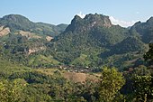
 Hilly landscape in Kalaw area, Shan Hills, Myanmar
 -
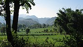
 The Shan Hills as seen from Inle Lake
 -
 The Shan Hills inMae Hong Son Province
 -
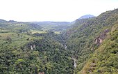 View over the Gokteik Gorge betweenPyin U Lwin
 -
 The Shan Hills between Chiang Mai and the border with Myanmar


See also
- List of Ultras of Southeast Asia
- Doi Inthanon
- Zomia (geography)
References
- ^ Loi Leng, Myanmar
- ^ Mong Ling Shan, Myanmar
- ^ Loi Pangnao (mountain) - Region: Shan State, Myanmar Archived 2012-04-23 at the Wayback Machine
- ^ Sarma, Satyendra Nath, Assamese Literature, Harrassowitz, Wiesbaden (1976)
- ^ Old maps of Shan Plateau
- ^ ISBN 978-0-19-924802-5
- ^ Shan Plateau, Encyclopædia Britannica
- ^ Peter H. Molnar, Plateau (Landform), Encyclopædia Britannica
- ^ Geology of Thailand - Ministry of Natural Resources and Environment, Bangkok
- ^ Encyclopædia Britannica, 1988, volume 10, page 694
- ^ Chiang Rai Tourism (in Thai)
- ^ Burma -Geography Archived 2012-02-07 at the Wayback Machine
- ^ "Kayah-Karen montane rain forests". Terrestrial Ecoregions. World Wildlife Fund.
- ^ Mae Ya Peak
- ^ Encyclopædia Britannica - Burma. Part 3
- ^ Myanmar Protected Areas - Context, Current Status and Challenges Archived 2012-04-17 at the Wayback Machine
- ^ Karen Cultural Profile - Geography
- ^ Potato Production in Myanmar[dead link]
- ^ Mydans, Seth (2011-03-24). "Earthquake Hits Myanmar". The New York Times.
- ^ "Myanmar Earthquake 2011: 6.8 Magnitude Temblor Hits Near Thailand". Huffington Post. 2011-03-24.