
Sparsholt, Oxfordshire
| Sparsholt | ||
|---|---|---|
Shire county | ||
| Region | ||
| Country | England | |
| Sovereign state | United Kingdom | |
| Post town | Wantage | |
| Postcode district | OX12 | |
| Dialling code | 01235 | |
| Police | Thames Valley | |
| Fire | Oxfordshire | |
| Ambulance | South Central | |
| UK Parliament | ||
| Website | Sparsholt & Westcot, Oxfordshire | |
Sparsholt is a village and civil parish about 3 miles (5 km) west of Wantage in the Vale of White Horse district of Oxfordshire. The parish includes the hamlet of Westcot about 1⁄2 mile (800 m) west of the village. Sparsholt was part of Berkshire until the 1974 boundary changes transferred the Vale of White Horse to Oxfordshire.
Geography
Sparsholt village is a spring line settlement at the foot of the Berkshire Downs escarpment. The parish measures more than 5 miles (8 km) miles north – south but less than 1 mile (1.6 km) east – west. It is bounded to the north by Stutfield Brook, a tributary of the River Ock. On the other sides it is bounded by field boundaries. In 1924 the parish's area was 5,311 acres (2,149 ha).[1] The highest point in the parish is Sparsholt Down, a chalk hill 1+1⁄2 miles (2.4 km) south of the village, whose summit is 801 feet (244 m) above sea level.
Toponymy
The earliest known record of the place-name is as Speresholte or Speresholt in an Anglo-Saxon charter from 963 now reproduced in the Cartularium Saxonicum. The Domesday Book of 1086 records it as Spersolt and a pipe roll from 1156 records it as Speresholt.[1] It is derived from Old English and probably means "wood where spear-shafts were obtained".[2]
Manor
The Domesday Book records that Sparsholt was a large
Parish church
The oldest part of the
On the north wall in the nave is a large
Amenities
A small annual income to run a parish Sunday school was established by private donations in the 18th century. In 1874 a school and adjoining cottages were built at the junction of Sparsholt Street and Church Way. In 1964 the school was closed and in 1968 the building was bought for conversion into a village hall. The hall was modernised in 2007.
Canal
Between 1805 and 1807 the section of the Wilts & Berks Canal between Longcot and Challow was completed.[8] It passes through the parish less than 3⁄4 mile (1.2 km) north of the village. Traffic on the canal had all but ceased by 1901 and the route was formally abandoned in 1914. The Wilts & Berks Canal Trust is currently restoring the canal.
Gallery
-
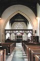 Inside Holy Cross parish church
 -
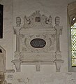 Monument to John and Bridget Playdell in Holy Rood church
 -
 Griffin Memorial Hall (right) and adjoining cottages (centre and left)
 -
 The Star Inn


References
- ^ a b c d e Ditchfield & Page 1924, pp. 311–319
- ^ Ekwall 1960, Sparsholt.
- ^ a b c d Historic England. "Church of the Holy Rood (Grade I) (1048702)". National Heritage List for England. Retrieved 29 August 2018.
- Central Council for Church Bell Ringers. Retrieved 29 August 2018.
- ^ "Ridgeway Benefice". Wantage Deanery. Retrieved 29 August 2018.
- ^ "Griffin Memorial Hall". Sparsholt & Westcot, Oxfordshire. Retrieved 21 June 2019.
- ^ The Star Inn
- ^ Dalby 2000, p. 23.
Bibliography
- Dalby, LJ (2000) [1971]. The Wilts and Berks Canal (3rd ed.). Usk: Oakwood Press. p. 23. ISBN 0-85361-562-4.
- Ditchfield, PH; Page, William, eds. (1924). "Sparsholt". A History of the County of Berkshire. Victoria County History. Vol. IV. assisted by John Hautenville Cope. London: The St Katherine Press. pp. 311–319.
- ISBN 0198691033.
- Haval, Nikhilesh. "Holy Cross, Sparsholt". Oxfordshire in 360 degrees. Nikreations.
- Pevsner, Nikolaus (1966). Berkshire. The Buildings of England. Harmondsworth: Penguin Books. pp. 223–224.