
Sulejów
Sulejów | |
|---|---|
 | |
|
UTC+2 (CEST) | |
| Postal code | 97-330 |
| Vehicle registration | EPI |
| National roads | |
| Website | http://www.sulejow.pl |
Sulejów [suˈlɛjuf] is a town in central Poland with 6,130 inhabitants (2020).[1] It is situated in Łódź Voivodeship. Sulejów gives its name to the protected area known as Sulejów Landscape Park.
The town was partially destroyed by the Luftwaffe in September 1939, causing more than 1000 deaths,[2][3]
History

The origins of Sulejów are associated with a village founded near the crossing of the Pilica river in the 12th century. The castle, which later sparked the development of a
A great event in the history of the town was a rally, which took place between 20 and 23 of June, 1318. This rally was the official ceremony of adopting and enacting the papal conditions and the resumption of the
Sulejów used to be located on the trade routes between
.jpg)
The town was damaged by the Swedes in 1655 during
Further destruction of the town occurred on 4 September 1939, during the German Luftwaffe bombing in time of the invasion of Poland which started World War II. As a result, 80% of the buildings, including the Old Town, were destroyed. That day almost 1,000 people died. The town then fell under German occupation until 1945. In mid-1940 the German police carried out mass arrests of over 100 Poles, including teachers, judges and students of secret Polish schools.[8]
After World War II, the town was partially rebuilt. From 1975 to 1998 it was located in Piotrków Voivodeship. In 1986 the Cistercians returned to the newly reopened monastery.
Climate
Sulejów has an oceanic climate (Köppen climate classification: Cfb) using the −3 °C (27 °F) isotherm or a humid continental climate (Köppen climate classification: Dfb) using the 0 °C (32 °F) isotherm.[9][10]
| Climate data for Sulejów (1991–2020 normals, extremes 1961–present) | |||||||||||||
|---|---|---|---|---|---|---|---|---|---|---|---|---|---|
| Month | Jan | Feb | Mar | Apr | May | Jun | Jul | Aug | Sep | Oct | Nov | Dec | Year |
| Record high °C (°F) | 14.0 (57.2) |
18.1 (64.6) |
22.7 (72.9) |
29.9 (85.8) |
31.2 (88.2) |
35.9 (96.6) |
36.5 (97.7) |
38.0 (100.4) |
35.2 (95.4) |
26.0 (78.8) |
18.8 (65.8) |
15.3 (59.5) |
38.0 (100.4) |
| Mean daily maximum °C (°F) | 1.1 (34.0) |
2.8 (37.0) |
7.3 (45.1) |
14.4 (57.9) |
19.4 (66.9) |
22.6 (72.7) |
25.2 (77.4) |
25.0 (77.0) |
19.2 (66.6) |
13.2 (55.8) |
6.8 (44.2) |
2.3 (36.1) |
13.3 (55.9) |
| Daily mean °C (°F) | −1.7 (28.9) |
−0.5 (31.1) |
2.9 (37.2) |
8.7 (47.7) |
13.5 (56.3) |
16.9 (62.4) |
19.0 (66.2) |
18.6 (65.5) |
13.6 (56.5) |
8.5 (47.3) |
3.8 (38.8) |
−0.2 (31.6) |
8.6 (47.5) |
| Mean daily minimum °C (°F) | −4.3 (24.3) |
−3.6 (25.5) |
−1.0 (30.2) |
3.1 (37.6) |
7.7 (45.9) |
11.1 (52.0) |
13.0 (55.4) |
12.6 (54.7) |
8.6 (47.5) |
4.7 (40.5) |
1.0 (33.8) |
−2.6 (27.3) |
4.2 (39.6) |
| Record low °C (°F) | −32.2 (−26.0) |
−30.6 (−23.1) |
−25.1 (−13.2) |
−7.2 (19.0) |
−3.8 (25.2) |
−0.4 (31.3) |
0.0 (32.0) |
1.7 (35.1) |
−3.4 (25.9) |
−8.0 (17.6) |
−18.2 (−0.8) |
−28.3 (−18.9) |
−32.2 (−26.0) |
| Average precipitation mm (inches) | 30.6 (1.20) |
28.5 (1.12) |
34.1 (1.34) |
38.5 (1.52) |
64.0 (2.52) |
73.8 (2.91) |
84.6 (3.33) |
58.1 (2.29) |
50.9 (2.00) |
41.8 (1.65) |
35.6 (1.40) |
32.3 (1.27) |
572.8 (22.55) |
| Average extreme snow depth cm (inches) | 7.0 (2.8) |
6.4 (2.5) |
4.6 (1.8) |
1.6 (0.6) |
0.1 (0.0) |
0.0 (0.0) |
0.0 (0.0) |
0.0 (0.0) |
0.0 (0.0) |
0.2 (0.1) |
2.3 (0.9) |
3.9 (1.5) |
7.0 (2.8) |
| Average precipitation days (≥ 0.1 mm) | 16.20 | 14.24 | 14.13 | 12.07 | 13.83 | 13.67 | 14.43 | 11.97 | 11.93 | 13.10 | 14.45 | 16.13 | 166.16 |
| Average snowy days (≥ 0 cm) | 15.5 | 14.7 | 7.2 | 1.2 | 0.0 | 0.0 | 0.0 | 0.0 | 0.0 | 0.3 | 4.2 | 10.0 | 53.1 |
| Average relative humidity (%)
|
86.8 | 84.1 | 78.3 | 70.8 | 72.3 | 73.4 | 72.6 | 72.3 | 79.3 | 84.2 | 88.6 | 88.6 | 79.3 |
| Mean monthly sunshine hours | 53.0 | 71.6 | 125.5 | 188.4 | 243.1 | 245.7 | 251.5 | 244.8 | 165.1 | 111.7 | 53.1 | 42.0 | 1,795.4 |
| Source 1: Institute of Meteorology and Water Management[11][12][13][14][15][16][17][18] | |||||||||||||
| Source 2: Meteomodel.pl (records, relative humidity 1991–2020)[19][20][21] | |||||||||||||
Demographics
| Year | Pop. | ±% |
|---|---|---|
| 1890 | 4,027 | — |
| 1897 | 4,636 | +15.1% |
| 1910 | 5,284 | +14.0% |
| 1921 | 5,718 | +8.2% |
| 1931 | 6,387 | +11.7% |
| 1939 | 7,048 | +10.3% |
| 1950 | 3,873 | −45.0% |
| 1960 | 4,854 | +25.3% |
| 2010 | 6,418 | +32.2% |
| Source: [22][23] | ||
Gallery
-
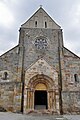 Facade and portal of the Saint Thomas of Canterbury church
 -
 Monastery
 -
 19th-century fire station which still operates today
 -
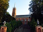 Saint Florian church

_by_Ron.jpg)
_by_Ron.jpg)

References
- ^ a b "Local Data Bank". Statistics Poland. Retrieved 7 November 2021. Data for territorial unit 1010094.
- ISBN 0-00-637194-9Page 85
- ^ History of Sulejów
- ^ Słownik geograficzny Królestwa Polskiego i innych krajów słowiańskich, Tom XI (in Polish). Warszawa. 1890. p. 567.
{{cite book}}: CS1 maint: location missing publisher (link) - ^ Atlas historyczny Polski. Województwo sieradzkie i województwo łęczyckie w drugiej połowie XVI wieku. Część I. Mapy, plany (in Polish). Warszawa: Instytut Historii Polskiej Akademii Nauk. 1998. p. 4.
- ^ a b Słownik geograficzny Królestwa Polskiego i innych krajów słowiańskich, Tom XI, p. 565
- ^ Zieliński, Stanisław (1913). Bitwy i potyczki 1863-1864. Na podstawie materyałów drukowanych i rękopiśmiennych Muzeum Narodowego w Rapperswilu (in Polish). Rapperswil: Fundusz Wydawniczy Muzeum Narodowego w Rapperswilu. p. 28.
- ^ Wardzyńska, Maria (2009). Był rok 1939. Operacja niemieckiej policji bezpieczeństwa w Polsce. Intelligenzaktion (in Polish). Warszawa: IPN. p. 266.
- .
- ISSN 1027-5606.
- ^ "Średnia dobowa temperatura powietrza". Normy klimatyczne 1991-2020 (in Polish). Institute of Meteorology and Water Management. Archived from the original on 3 December 2021. Retrieved 22 February 2022.
- ^ "Średnia minimalna temperatura powietrza". Normy klimatyczne 1991-2020 (in Polish). Institute of Meteorology and Water Management. Archived from the original on 15 January 2022. Retrieved 22 February 2022.
- ^ "Średnia maksymalna temperatura powietrza". Normy klimatyczne 1991-2020 (in Polish). Institute of Meteorology and Water Management. Archived from the original on 15 January 2022. Retrieved 22 February 2022.
- ^ "Miesięczna suma opadu". Normy klimatyczne 1991-2020 (in Polish). Institute of Meteorology and Water Management. Archived from the original on 9 January 2022. Retrieved 22 February 2022.
- ^ "Liczba dni z opadem >= 0,1 mm". Normy klimatyczne 1991-2020 (in Polish). Institute of Meteorology and Water Management. Archived from the original on 15 January 2022. Retrieved 22 February 2022.
- ^ "Średnia grubość pokrywy śnieżnej". Normy klimatyczne 1991-2020 (in Polish). Institute of Meteorology and Water Management. Archived from the original on 15 January 2022. Retrieved 22 February 2022.
- ^ "Liczba dni z pokrywą śnieżna > 0 cm". Normy klimatyczne 1991-2020 (in Polish). Institute of Meteorology and Water Management. Archived from the original on 21 January 2022. Retrieved 22 February 2022.
- ^ "Średnia suma usłonecznienia (h)". Normy klimatyczne 1991-2020 (in Polish). Institute of Meteorology and Water Management. Archived from the original on 15 January 2022. Retrieved 22 February 2022.
- ^ "Sulejów Absolutna temperatura maksymalna" (in Polish). Meteomodel.pl. 6 April 2018. Retrieved 22 February 2022.
- ^ "Sulejów Absolutna temperatura minimalna" (in Polish). Meteomodel.pl. 6 April 2018. Retrieved 22 February 2022.
- ^ "Sulejów Średnia wilgotność" (in Polish). Meteomodel.pl. 6 April 2018. Retrieved 22 February 2022.
- ^ Dokumentacja Geograficzna (in Polish). Vol. 3/4. Warszawa: Instytut Geografii Polskiej Akademii Nauk. 1967. p. 49.
- ^ Stan i struktura ludności oraz ruch naturalny w przekroju terytorialnym w 2010 r. (PDF) (in Polish). Warszawa: Główny Urząd Statystyczny. 2011. p. 64. Archived from the original (PDF) on 13 November 2011.

| International | |
|---|---|
| National | |