
Talbotton, Georgia
Talbotton, Georgia | ||
|---|---|---|
FIPS code 13-75244[2] | | |
| GNIS feature ID | 0333180[3] | |
| Website | talbottonga | |
Talbotton is a city in Talbot County, Georgia, United States. The population was 970 at the 2010 census.[4] The city is the county seat of Talbot County.[5]
History
Talbotton was founded in 1828 as the seat of the newly formed Talbot County.[6] Both the county and the town were named for Governor Matthew Talbot.[7]
Talbotton may be best known in history as the place where the immigrant Straus family got their start in retail sales in the 19th century. In 1896, the family acquired R. H. Macy & Co. in New York.[8]
Geography
Talbotton is located at 32°40′41″N 84°32′23″W / 32.67806°N 84.53972°W (32.678170, -84.539787).[9] According to the United States Census Bureau, the city has a total area of 3.1 square miles (8.0 km2), of which 3.1 square miles (8.0 km2) is land and 0.32% is water.
The city is located in the central portion of the county along
Climate
Talbotton has a humid subtropical climate (Köppen Cfa), with hot, humid summers and mild winters. The record high of 110 °F (43 °C) and record low of −6 °F (−21 °C) were recorded on July 19, 1913 and February 13, 1899, respectively.
On March 3, 2019, an EF4 tornado struck the town at low-end EF3 strength, causing major damage to structures and trees in the town.[10][11]
| Climate data for Talbotton, 1981-2010 normals, extremes 1893-present | |||||||||||||
|---|---|---|---|---|---|---|---|---|---|---|---|---|---|
| Month | Jan | Feb | Mar | Apr | May | Jun | Jul | Aug | Sep | Oct | Nov | Dec | Year |
| Record high °F (°C) | 82 (28) |
83 (28) |
93 (34) |
96 (36) |
100 (38) |
105 (41) |
110 (43) |
107 (42) |
108 (42) |
100 (38) |
89 (32) |
83 (28) |
110 (43) |
| Mean daily maximum °F (°C) | 55.3 (12.9) |
59.8 (15.4) |
67.2 (19.6) |
73.9 (23.3) |
80.7 (27.1) |
86.6 (30.3) |
89.2 (31.8) |
88.0 (31.1) |
83.2 (28.4) |
74.3 (23.5) |
66.3 (19.1) |
56.7 (13.7) |
73.4 (23.0) |
| Mean daily minimum °F (°C) | 32.1 (0.1) |
35.2 (1.8) |
41.2 (5.1) |
48.4 (9.1) |
56.9 (13.8) |
65.5 (18.6) |
69.0 (20.6) |
68.4 (20.2) |
62.2 (16.8) |
49.9 (9.9) |
40.9 (4.9) |
33.8 (1.0) |
50.3 (10.2) |
| Record low °F (°C) | −5 (−21) |
−6 (−21) |
12 (−11) |
25 (−4) |
33 (1) |
42 (6) |
50 (10) |
50 (10) |
34 (1) |
23 (−5) |
8 (−13) |
1 (−17) |
−6 (−21) |
| Average precipitation inches (mm) | 4.38 (111) |
4.89 (124) |
5.38 (137) |
3.65 (93) |
3.19 (81) |
4.28 (109) |
5.00 (127) |
3.83 (97) |
3.51 (89) |
3.03 (77) |
3.95 (100) |
4.61 (117) |
49.7 (1,262) |
| Average precipitation days (≥ 0.01 in) | 7.6 | 7.5 | 7.4 | 6.3 | 6.8 | 8.3 | 8.6 | 7.5 | 5.7 | 5.5 | 6.1 | 7.4 | 84.7 |
| Source: NOAA[12] | |||||||||||||
Demographics
| Census | Pop. | Note | %± |
|---|---|---|---|
| 1870 | 796 | — | |
| 1880 | 1,008 | 26.6% | |
| 1890 | 1,140 | 13.1% | |
| 1900 | 1,131 | −0.8% | |
| 1910 | 1,081 | −4.4% | |
| 1920 | 1,093 | 1.1% | |
| 1930 | 1,064 | −2.7% | |
| 1940 | 1,060 | −0.4% | |
| 1950 | 1,175 | 10.8% | |
| 1960 | 1,163 | −1.0% | |
| 1970 | 1,045 | −10.1% | |
| 1980 | 1,140 | 9.1% | |
| 1990 | 1,046 | −8.2% | |
| 2000 | 1,019 | −2.6% | |
| 2010 | 970 | −4.8% | |
| 2020 | 742 | −23.5% | |
| U.S. Decennial Census[13] 1850-1870[14] 1880[15] 1890-1910[16] 1920-1930[17] 1930-1940[18] 1940-1950[19] 1960-1980[20]1980-2000[21] | |||
| Race | Num. | Perc. |
|---|---|---|
White (non-Hispanic)
|
122 | 16.44% |
Black or African American (non-Hispanic)
|
600 | 80.86% |
Native American
|
1 | 0.13% |
Asian
|
2 | 0.27% |
Other/Mixed
|
7 | 0.94% |
Latino
|
10 | 1.35% |
As of the 2020 United States census, there were 742 people, 372 households, and 222 families residing in the city.
Education
The Talbot County School District headquarters is located in the city as well as the only school building in the entire county.[23] The district and school has 48 full-time teachers and over 792 students.[24]
- Central Elementary/High School
Notable people
- John W. Bower, signatory to the Texas Declaration of Independence, member of the House of Representatives of the Republic of Texas, and Chief justice of Refugio County, Texas; born in Talbotton.
- Charles Henry Jones, journalist, editor, and political figure, born in Talbotton.
- Clarence Jordan, farmer and New Testament Greek scholar; born in Talbotton.
- 39th Governor of Georgia from 1847 to 1851; former resident of Talbotton.[25]
- Lady, American rapper; born in Talbotton.
- Voorhees College; born in Talbotton.
- Isidor Strauss, U.S. Representative from the NY-15 district (1894-1895) and co-founder of Macy's Department Store, who died during the sinking of the R.M.S. Titanic, lived in Talbotton as a youth.
Gallery
-
 Built in 1892 in the Queen Anne style, the Talbot County Courthouse was added to the National Register of Historic Places on September 18, 1980.
 -
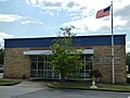
 Talbotton City Hall
 -
 Talbotton Post Office (ZIP code: 31827)
 -
 Talbot County Public Library
 -
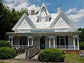 The Newton P. Carreker House was added to the National Register of Historic Places on August 26, 1980.
 -
 The Straus-LeVert Memorial Hall is a contributing property to the LeVert Historic District which was added to the National Register of Historic Places on January 11, 1976.
 -
 The David Shelton House was added to the National Register of Historic Places on September 17, 1980.
 -
 The George W. Towns House was added to the National Register of Historic Places on May 7, 1973.
 -
 The Weeks-Kimbrough House was added to the National Register of Historic Places on December 27, 1979.
 -
 Zion Episcopal Church was founded in the 1830s. Inside the church, above the plain wooden pews, are galleries meant for slave parishioners. The church is still in use today and was added to the National Register of Historic Places on May 8, 1974.


.JPG)


;_Talbotton,_GA_(NRHP).JPG)
.JPG)
.JPG)
.JPG)
;_Talbotton,_GA.JPG)
References
- ^ "2020 U.S. Gazetteer Files". United States Census Bureau. Retrieved December 18, 2021.
- ^ "U.S. Census website". United States Census Bureau. Retrieved January 31, 2008.
- ^ "US Board on Geographic Names". United States Geological Survey. October 25, 2007. Retrieved January 31, 2008.
- ^ "Talbotton, GA Profile: Facts & Data".
- ^ "Find a County". National Association of Counties. Retrieved June 7, 2011.
- ISBN 978-1135948597. Retrieved November 30, 2013.
- ISBN 0-915430-00-2.
- ^ "Historical Markers by County - GeorgiaInfo". March 4, 2019. Archived from the original on March 4, 2019. Retrieved March 4, 2019.
- ^ "US Gazetteer files: 2010, 2000, and 1990". United States Census Bureau. February 12, 2011. Retrieved April 23, 2011.
- ^ "Beauregard-Smiths Station EF-4 Tornado (Macon/Lee Counties) March 3, 2019". Birmingham, Alabama: National Weather Service. National Weather Service Weather Forecast Office in Birmingham, Alabama. March 5, 2019. Retrieved March 5, 2019.
- ^ Update #3 From NWS Damage Surveys Including the Long-Track Tornado which Traversed from Macon and Lee Counties in Alabama Through Muscogee, Harris and Talbotton Counties in Georgia (Report). Iowa Environmental Mesonet. March 5, 2019. Retrieved March 5, 2019.
{{cite report}}: Unknown parameter|agency=ignored (help) - ^ "NOWData - NOAA Online Weather Data". National Oceanic and Atmospheric Administration. Retrieved January 26, 2021.
- US Census Bureau.
- US Census Bureau. 1870.
- US Census Bureau. 1880.
- US Census Bureau. 1930.
- US Census Bureau. 1930. p. 253.
- US Census Bureau. 1940.
- US Census Bureau. 1980.
- US Census Bureau. 1980.
- US Census Bureau. 2000.
- ^ "Explore Census Data". data.census.gov. Retrieved December 18, 2021.
- ^ Georgia Board of Education, Retrieved June 26, 2010.
- ^ School Stats, Retrieved June 26, 2010.
- ^ "Towns, George Washington Bonaparte, (1801 - 1854)". Biographical Directory of the United States Congress. Retrieved September 4, 2012.
External links
- City-Data.com Comprehensive Statistical Data and more about Talbotton
Municipalities and communities of Talbot County, Georgia, United States | ||
|---|---|---|
| Cities |  | |
| Towns | ||
| CDP | ||
| Other unincorporated communities | ||
| Footnotes | ‡This populated place also has portions in an adjacent county or counties | |
| ||
| International | |
|---|---|
| National | |
| Geographic | |