
Talk:Kherson Oblast
| This is the talk page for discussing improvements to the Kherson Oblast article. This is not a forum for general discussion of the article's subject. |
Article policies
|
| Find sources: Google (books · news · scholar · free images · WP refs) · FENS · JSTOR · TWL |
| This It is of interest to the following WikiProjects: | |||||||||||
| |||||||||||

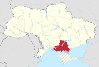
Irredentist POV pushing with maps
In regard to this edit and related ones. No. Crimea is "disputed" in the sense that Russia claims it. But Crimea is still internationally recognized as part of Ukraine, like it or not. If anything, the UN condemned the Russian occupation of Crimea. Until that changes, it's POV pushing to claim that Crimea is "disputed", especially in an infobox where it's impossible to provide context. If you want to explain the details behind the occupation in text, that would work, but this article isn't the place for it.
It makes some sense to have a map which marks Crimea differently in main articles, such as Crimea, Ukraine and Russia. But to spread that to every single Ukraine-related article is just irredentist and nationalistic POV territory marking. It's disruptive and tendentious. This supposed "consensus" that the edit summary refers to was relevant only to the main articles; Crimea, Ukraine and Russia. Territory marking on all these other articles is just obnoxious. Stop it.Volunteer Marek (talk) 01:29, 24 March 2015 (UTC)
- It is ridiculous to say that calling Crimea a disputed region is POV pushing. The whole point of calling it a disputed region is for NPOV as it is disputed between Ukraine and Russia, which both claim it as part of their own territory. Russia doesn't just "occupy" the region, it effectively administers it as part of its own territory. Not the entire international community recognizes it as a part of Ukraine, although most of it does. The UN resolution was not unanimous, there is still a small number of nations recognizing it as a part of Russia. The maps don't depict Crimea as an integral part of Russia and neither do they depict it as an integral part of Ukraine, because it is a disputed region between the two governments and the only NPOV thing to do is to depict it as such. --Leftcry (talk) 02:01, 24 March 2015 (UTC)
- Again, the international community, as represented by the UN does recognize Crimea as part of Ukraine. There's a couple of Russia's puppet states that don't. So what? It's a fringe. That's exactly why this is POV - it's putting the views of a fringe on the same footing as mainstream view. It IS an integral part of Ukraine. Please stop it with the nationalist edits with these junkety POV maps.Volunteer Marek (talk) 02:25, 24 March 2015 (UTC)
- The UN doesn't own the entire international community and although most countries are a part of the UN that doesn't mean that they don't have a right to their own sovereign decision. It's not just "a couple of Russia's puppet states", it's completely independent and recognized sovereign governments such as Afghanistan, Venezuela, Nicaragua and some others. Saying that the entire international community recognizes Crimea as Ukraine is simply like saying those sovereign states aren't a part of the international community. The UN, as an organization, may recognize Crimea as Ukraine but it doesn't speak for each country's own recognition. Wikipedia does not treat Crimea as an integral part of Ukraine and neither does it treat it as an integral part of Russia as either of those stances are POV pushing which is why it is treated as a disputed region for NPOV. You may think of it as an integral part of Ukraine, but that is your personal opinion and you should not POV push and remove NPOV maps per WP:JUSTDONTLIKEIT. Also stop claiming I am the one making nationalist edits by showing Crimea as a disputed region as you are the one who is trying to edit against NPOV by showing a disputed region as an integral part of a country. Also don't assume that just because I reverted one of your edits on a different page that I did so for revenge. I did so because I thought that your edits on that page were completely dubious, however that's a different discussion. --Leftcry (talk) 02:39, 24 March 2015 (UTC)]
- The UN doesn't own the entire international community and although most countries are a part of the UN that doesn't mean that they don't have a right to their own sovereign decision. It's not just "a couple of Russia's puppet states", it's completely independent and recognized sovereign governments such as Afghanistan, Venezuela, Nicaragua and some others. Saying that the entire international community recognizes Crimea as Ukraine is simply like saying those sovereign states aren't a part of the international community. The UN, as an organization, may recognize Crimea as Ukraine but it doesn't speak for each country's own recognition. Wikipedia does not treat Crimea as an integral part of Ukraine and neither does it treat it as an integral part of Russia as either of those stances are POV pushing which is why it is treated as a disputed region for NPOV. You may think of it as an integral part of Ukraine, but that is your personal opinion and you should not POV push and remove NPOV maps per
- Again, the international community, as represented by the UN does recognize Crimea as part of Ukraine. There's a couple of Russia's puppet states that don't. So what? It's a fringe. That's exactly why this is POV - it's putting the views of a fringe on the same footing as mainstream view. It IS an integral part of Ukraine. Please stop it with the nationalist edits with these junkety POV maps.Volunteer Marek (talk) 02:25, 24 March 2015 (UTC)
- You tell in edit summary here that "There was a consensus long ago, right after its annexation by Russia, that Crimea will be depicted as a disputed region on maps and articles." Could you please provide any link to discussion which resulted in WP:Consensus as you tell? My very best wishes (talk) 16:41, 24 March 2015 (UTC)
- There were a number of discussions regarding Crimea and maps that took place mainly on Talk:Ukraine, so there isn't just a single one that I can link here as there are more than one, however the final consensus reached was to treat Crimea as a disputed territory on Wikipedia as that is NPOV. You are free to look into the archives and read those discussions which took place right after Crimea's annexation. I myself did not participate in them as I was not very active on Wikipedia at the time, however I believe User:Iryna Harpy was one of the people who did participate, so maybe she can help you find the most relevant discussions. --Leftcry (talk) 20:47, 24 March 2015 (UTC)
- You said there was a discussion with consensus about this, but you can not provide any links to discussion(s) supporting your statement. If this is the case, I should assume there was no in fact such consensus and possibly revert your edits about this. My very best wishes (talk) 21:24, 24 March 2015 (UTC)
- Did you even read my reply? I just said there were a number of discussions not just a single one, so linking just one would not show the complete situation. Then I told you that User:Iryna Harpy was one of the people who participated in those discussions, so she can help with finding the most relevant one of those, however I'm sure that if you want to understand the entire situation you would have to read quite a few of them. They are all located in the archives of Talk:Ukraine, just go look for yourself. --Leftcry (talk) 23:49, 24 March 2015 (UTC)
- You said there was a discussion with consensus about this, but you can not provide any links to discussion(s) supporting your statement. If this is the case, I should assume there was no in fact such consensus and possibly revert your edits about this. My very best wishes (talk) 21:24, 24 March 2015 (UTC)
- There were a number of discussions regarding Crimea and maps that took place mainly on Talk:Ukraine, so there isn't just a single one that I can link here as there are more than one, however the final consensus reached was to treat Crimea as a disputed territory on Wikipedia as that is NPOV. You are free to look into the archives and read those discussions which took place right after Crimea's annexation. I myself did not participate in them as I was not very active on Wikipedia at the time, however I believe User:Iryna Harpy was one of the people who did participate, so maybe she can help you find the most relevant discussions. --Leftcry (talk) 20:47, 24 March 2015 (UTC)
- You tell in edit summary here that "There was a consensus long ago, right after its annexation by Russia, that Crimea will be depicted as a disputed region on maps and articles." Could you please provide any link to discussion which resulted in WP:Consensus as you tell? My very best wishes (talk) 16:41, 24 March 2015 (UTC)
Yes, I can attest to the lengthy RfCs regarding the use of a map depicting facts on the ground on the Ukraine article. While there was much in the way of dispute as to
Rather than turn this into an ongoing bone of contention, I would invite
- It's obvious the ownership of Crimea is disputed. Russia occupies and administers it, Ukraine wants it back. The U.N. is, as usual, toothless in the matter - it cannot change reality and say no, there's no dispute. Maps showing the states of Ukraine should indicate the territory is disputed. --NeilN talk to me 00:48, 25 March 2015 (UTC)
I think that in articles specifically about the Russian-Ukrainian conflict, or the few top level articles such as Ukraine and Crimea, it makes sense to depict Crimea as disputed. But going through and changing every single map of Ukraine in fairly minor articles such as this one is just tendentious POV pushing and territory marking.Volunteer Marek (talk) 01:05, 25 March 2015 (UTC)
- Editors should not pick and choose which articles have maps which show it as disputed (or not). It should be consistent in all articles. Thanks. Ism schism (talk) 01:36, 25 March 2015 (UTC)
- Yes, it should, and I fixed it. I did not ask anyone to discuss. That was a very simple question, specifically to Leftcry. If he tells something, I thought he could support his words by a link to a relevant discussion with alleged consensus. So far no one provided a single link to any discussion with consensus about this. That's fine, I just wanted to be sure. My very best wishes (talk) 01:54, 25 March 2015 (UTC)
- Everyone here except for you and Volunteer Marek said that the maps should show Crimea as disputed and what Ism schism meant is that these maps should be consistent with the ones on the main articles. You didn't "fix" anything, you did the complete opposite and started editing against consensus. For the third time, if you want to see the many discussions regarding Crimea and maps which took place after Crimea's annexation then go to Talk:Ukraine and look through its archives. There were many discussions and linking just one would not show the entire situation so I strongly encourage you to go there and look through all of them if you really do want to be sure. --Leftcry (talk) 02:27, 25 March 2015 (UTC)
- There was a discussion at either Russia or Ukraine that only concerned what shade of green to paint Crimea in those two specific maps. It was probably extended to Crimea as well, but I wasn't involved in that discussion. The consensus covered only the maps at those articles and it was never agreed to expand the consensus to every single map in Wikipedia that shows Crimea. Until the war is over and a final settlement on Crimea has been agreed to, Crimea should be marked as Ukrainian and the Russian invasion and occupation ignored. --Taivo (talk) 02:30, 25 March 2015 (UTC)
- The maps showing Crimea as disputed were there for quite a while now, the replacement of those maps with the ones showing Crimea as integrally Ukrainian is recent. I do completely agree with Ism schism in the sense that it is completely inconstant to show Crimea as a disputed region on one article and show it as a complete integral part of Ukraine on the others. I also agree with Iryna Harpy and NeilN that it is obvious that Crimea has disputed status and that it should be depicted as such in maps, as well as that doing otherwise is POV pushing. --Leftcry (talk) 02:39, 25 March 2015 (UTC)
- There is no difference between showing occupied Crimea as part of Ukraine and showing occupied South Ossetia and Abkhazia as part of Georgia or occupied Transnistria as part of Moldova. Until a final peace settlement officially changes the borders, invaded and occupied territory is still shown as an integral part of the nation that they legally belong to. --Taivo (talk) 02:45, 25 March 2015 (UTC)
- That seems to mean that Ukraine admits Crimea to be part of the Russian Fed. I don't assess how likely this could be happening but let me give my best example: China (PRC) and Taiwan (RoC) are currently in a rather peaceful relationship, but China never stops claiming Taiwan to be part of its territories and all maps in Wikimedia depicts Taiwan as an independent sovereign from China. Your requirement of a "final peaceful settlement" is untenable. -- Sameboat - 同舟 (talk · contri.) 03:00, 25 March 2015 (UTC)
- There is no difference between showing occupied Crimea as part of Ukraine and showing occupied South Ossetia and Abkhazia as part of Georgia or occupied Transnistria as part of Moldova. Until a final peace settlement officially changes the borders, invaded and occupied territory is still shown as an integral part of the nation that they legally belong to. --Taivo (talk) 02:45, 25 March 2015 (UTC)
- The maps showing Crimea as disputed were there for quite a while now, the replacement of those maps with the ones showing Crimea as integrally Ukrainian is recent. I do completely agree with Ism schism in the sense that it is completely inconstant to show Crimea as a disputed region on one article and show it as a complete integral part of Ukraine on the others. I also agree with Iryna Harpy and NeilN that it is obvious that Crimea has disputed status and that it should be depicted as such in maps, as well as that doing otherwise is POV pushing. --Leftcry (talk) 02:39, 25 March 2015 (UTC)
- There was a discussion at either Russia or Ukraine that only concerned what shade of green to paint Crimea in those two specific maps. It was probably extended to Crimea as well, but I wasn't involved in that discussion. The consensus covered only the maps at those articles and it was never agreed to expand the consensus to every single map in Wikipedia that shows Crimea. Until the war is over and a final settlement on Crimea has been agreed to, Crimea should be marked as Ukrainian and the Russian invasion and occupation ignored. --Taivo (talk) 02:30, 25 March 2015 (UTC)
- Everyone here except for you and Volunteer Marek said that the maps should show Crimea as disputed and what Ism schism meant is that these maps should be consistent with the ones on the main articles. You didn't "fix" anything, you did the complete opposite and started editing against consensus. For the third time, if you want to see the many discussions regarding Crimea and maps which took place after Crimea's annexation then go to Talk:Ukraine and look through its archives. There were many discussions and linking just one would not show the entire situation so I strongly encourage you to go there and look through all of them if you really do want to be sure. --Leftcry (talk) 02:27, 25 March 2015 (UTC)
- Yes, it should, and I fixed it. I did not ask anyone to discuss. That was a very simple question, specifically to Leftcry. If he tells something, I thought he could support his words by a link to a relevant discussion with alleged consensus. So far no one provided a single link to any discussion with consensus about this. That's fine, I just wanted to be sure. My very best wishes (talk) 01:54, 25 March 2015 (UTC)
- @Taivo: Wikipedia is ever-changing in order to keep itself updated to the current state of our knowledge. Unless the article only covers specific historical event (which "Kherson Oblast" is clearly not), any article about entity still exists in modern day should be updated accordingly to reflect the current state of event regardless of its role in the said conflict (Crimea crisis). Ironically about your "until the war is over and a final settlement" statement, the so-called war in Crimea is pretty much settled and there is no signs its de facto annexation by Russia would be changed or even reverted in any foreseeable future. -- Sameboat - 同舟 (talk · contri.) 02:49, 25 March 2015 (UTC)
- @Sameboat: Please show me the treaty by which Ukraine has ceded ownership of Crimea to Russia and/or the UN resolution which recognizes Russian seizure and incorporation of Crimea. Until you can, then the war is certainly not over. Just because there is no active fighting for Ukraine to retake its property, doesn't mean that the issue has been "settled". You cannot tell the future. Wikipedia does not "recognize" the independence of Transnistria or Abkhazia or South Ossetia in its administrative division maps of Moldova or Georgia. There is no reason to treat Ukraine any differently. Until Ukraine officially cedes Crimea to Russia, it is still legally a part of Ukraine. --Taivo (talk) 03:01, 25 March 2015 (UTC)
- Those territories are break-away regions which is slightly different from the situation in Crimea. Something more relatable is Golan Heights. Syria never officially ceded the territory to Israel however it has no control to the region and is depicted the same way as Crimea is on those maps. Golan Heights is an occupied region and is depicted that way, Crimea is more than just an occupied region as Russia also administers it, so it is also disputed and should also be depicted as such on maps. --Leftcry (talk) 03:09, 25 March 2015 (UTC)
- What makes Crimea virtually identical to Transnistria, Abkhazia, and South Ossetia is that it is precisely the same process and the same invader in each case--Russian "hybrid war". If it is the same antagonist and the same process in each case, then the situations in Moldova, Ukraine, and Georgia should be treated the same throughout. Let the situation surrounding Israel be treated the way that those editors choose since there are differences. But surrounding Russia we have the same invader (Russia), the same tactics (hybrid war), the same victims (former Soviet states), and the same result (frozen war) in each case. Therefore they should all be treated the same--without marking "disputes" on the administrative division maps, light green on the country maps. --Taivo (talk) 03:16, 25 March 2015 (UTC)
- That doesn't change the fact that those territories aren't disputed between two UN members, Crimea is. That's what makes it different from the cases with break-away regions and similar to the case with Golan Heights. Crimea is already depicted as a disputed region on most articles relating to Crimea and maps on the main articles. It is completely redundant to show it as a disputed region there, but not do that here as that is not consistent. --Leftcry (talk) 03:26, 25 March 2015 (UTC)
- TBH, I'm not knowledgable about the current states or news about Transnistria, Abkhazia and South Ossetia. But depicting Crimea as an disputed territory from Ukraine in all modern maps comply with our NPOV policy perfectly. We don't need to predict how the "conflict without active fighting" will turn out. Any depiction of "Crimea as an undisputed Ukrainian territory" is either historical (inaccurate to the present state) or prediction, which constitutes ]
- No, Leftcry. It is completely consistent with the way that Abkhazia and South Ossetia are treated at Georgia (in light green), but not marked on the administrative division maps. Crimea is no different than these other regions in any sense other than Russia has overtly claimed the territory after it "broke away". You're simply not seeing the big picture here in your attempts to push this POV edit on the administrative maps. The way we treat Transnistria, South Ossetia, Abkhazia, Crimea, and the Donbass should be identical across the board because they are all part of a larger process of post-Soviet Russian aggression and expansion.
- No, Sameboat. And if you are not knowledgeable about Moldova or Georgia and Russian occupation of parts of those states, then you won't understand the situation of Crimea. This situation is no different than trying to accurately mark those areas on a map that have been invaded in the middle of the war. We do not mark these other areas of Russian aggression and occupation in Moldova or Georgia. We should treat Ukraine no differently while it is in the middle of a war. --Taivo (talk) 03:37, 25 March 2015 (UTC)
- The conflict in Crimea ended almost a year ago and is now in a state of territorial dispute. There is no war including Crimea as of right now. The current war in Ukraine is in the Donbass not Crimea. --Leftcry (talk) 03:41, 25 March 2015 (UTC)
- "The conflict in Crimea ended almost a year ago"? Are you actually of the notion that the war in Crimea is separate from the war in Donbass? There is only one war--Ukraine versus Russia. Just because one front is not active at this time doesn't mean that the war is over. If "the war is over", please show me the treaty by which Ukraine ceded Crimea to Russia or the UN resolution by which the world recognized the "end of the war in Crimea". Indeed, except for a dozen or so Russian allies or anti-Western dictatorships, every other country of the world still overtly recognizes the Ukrainian sovereignty over Crimea. That's hardly a finished war. --Taivo (talk) 05:44, 25 March 2015 (UTC)
- The conflict in Crimea ended almost a year ago and is now in a state of territorial dispute. There is no war including Crimea as of right now. The current war in Ukraine is in the Donbass not Crimea. --Leftcry (talk) 03:41, 25 March 2015 (UTC)
- TBH, I'm not knowledgable about the current states or news about Transnistria, Abkhazia and South Ossetia. But depicting Crimea as an disputed territory from Ukraine in all modern maps comply with our NPOV policy perfectly. We don't need to predict how the "conflict without active fighting" will turn out. Any depiction of "Crimea as an undisputed Ukrainian territory" is either historical (inaccurate to the present state) or prediction, which constitutes ]
- That doesn't change the fact that those territories aren't disputed between two UN members, Crimea is. That's what makes it different from the cases with break-away regions and similar to the case with Golan Heights. Crimea is already depicted as a disputed region on most articles relating to Crimea and maps on the main articles. It is completely redundant to show it as a disputed region there, but not do that here as that is not consistent. --Leftcry (talk) 03:26, 25 March 2015 (UTC)
- What makes Crimea virtually identical to Transnistria, Abkhazia, and South Ossetia is that it is precisely the same process and the same invader in each case--Russian "hybrid war". If it is the same antagonist and the same process in each case, then the situations in Moldova, Ukraine, and Georgia should be treated the same throughout. Let the situation surrounding Israel be treated the way that those editors choose since there are differences. But surrounding Russia we have the same invader (Russia), the same tactics (hybrid war), the same victims (former Soviet states), and the same result (frozen war) in each case. Therefore they should all be treated the same--without marking "disputes" on the administrative division maps, light green on the country maps. --Taivo (talk) 03:16, 25 March 2015 (UTC)
- Those territories are break-away regions which is slightly different from the situation in Crimea. Something more relatable is Golan Heights. Syria never officially ceded the territory to Israel however it has no control to the region and is depicted the same way as Crimea is on those maps. Golan Heights is an occupied region and is depicted that way, Crimea is more than just an occupied region as Russia also administers it, so it is also disputed and should also be depicted as such on maps. --Leftcry (talk) 03:09, 25 March 2015 (UTC)
- @Sameboat: Please show me the treaty by which Ukraine has ceded ownership of Crimea to Russia and/or the UN resolution which recognizes Russian seizure and incorporation of Crimea. Until you can, then the war is certainly not over. Just because there is no active fighting for Ukraine to retake its property, doesn't mean that the issue has been "settled". You cannot tell the future. Wikipedia does not "recognize" the independence of Transnistria or Abkhazia or South Ossetia in its administrative division maps of Moldova or Georgia. There is no reason to treat Ukraine any differently. Until Ukraine officially cedes Crimea to Russia, it is still legally a part of Ukraine. --Taivo (talk) 03:01, 25 March 2015 (UTC)
- @Taivo: Wikipedia is ever-changing in order to keep itself updated to the current state of our knowledge. Unless the article only covers specific historical event (which "Kherson Oblast" is clearly not), any article about entity still exists in modern day should be updated accordingly to reflect the current state of event regardless of its role in the said conflict (Crimea crisis). Ironically about your "until the war is over and a final settlement" statement, the so-called war in Crimea is pretty much settled and there is no signs its de facto annexation by Russia would be changed or even reverted in any foreseeable future. -- Sameboat - 同舟 (talk · contri.) 02:49, 25 March 2015 (UTC)
TaivoLinguist, stop changing maps before this discussion is over. You're pushing your POV ignoring the fact that half of the users who commented on this did not agree with this decision. Your disruptive change of maps on articles of Oblasts of Ukraine before a consensus is even reached is simply POV pushing. --Leftcry (talk) 04:08, 25 March 2015 (UTC)
- If you are going to show the parts of Ukraine claimed by neighboroughing countries, then a neutral POV approach would be to show all of them, not just the ones you approve of. I suggest blue hatching for parts that Russia claims, red hatching for parts claimed by Poland, and yellow hatching for parts claimed by Romania. With respect of Polish claims - they vary - suggest thick hatching for the part to the pre-1939 frontier and thin hatching for the pre-Khmelnytsky Uprising frontier. Alternatively we could just omit all the claims from the map as they are not really needed for the purpose the map is being used for.-- Toddy1 (talk) 06:44, 25 March 2015 (UTC)
No Hatching Hatching 

.svg)
- By the way, the current hatching is a complete failure. You cannot see it on my computer from the normal article page.-- Toddy1 (talk) 06:46, 25 March 2015 (UTC)
- (@Toddy. The hatching was previously removed from the map on this article by User:My very best wishes. --Taivo (talk) 07:13, 25 March 2015 (UTC))
Although not expressed in a particularly helpful way, Toddy1 is correct to note that there are dozens of disputed territories globally, which are not typically displayed on maps. What's distinct in the Crimea case is that it is a situation where the de facto governance of Crimea - as part of Russia - is different from the the situation recognized by the majority of UN states. I can't think of many other situations where this is the case. Comparions to Abkazhia, Transnistria etc are less helpful. While undoubtedly supported by Russia, none of these claim to be an integral part of Russian territory - they claim to be independent states. What's clear? What's clear is that Crimea is a disputed territory. That's not just about UN recongition - dozens of sources could tell us this. I think I like its entry under the National Geogaphic article title 6 of the World's Most Worrisome Disputed Territories as about as unequivocal a statement on this as we can get! However, what's also important is that we remember that this and other geographical articles are not about Crimea. My view is that the colour of Crimea should not, therefore, be an important or distinguishing feature on a map which is, ultimately, not about Crimea. Furthermore, we shouldn't pretend that maps are an easy or neutral tool to straightforwadly represent the world - they're not, they are the products of a series of difficult representational decisions (such as this). I wonder if depictions of
- Actually, it's common Wikipedia practice to mark disputed territories, even in infobox maps. Check the maps at Gansu or Andhra Pradesh. I see no reason to treat Crimea differently.Anonimu (talk) 08:55, 25 March 2015 (UTC)
- @Anoimu - Yes, I agree, that's what I said. But equally we don't show all territory disputes, so we need to judge what to do in each individual case. The point that I was making is that perhaps by doing so in a more subtle way on non-Crimea related articles, we avoid the situation where a tangential topic hijacks an article. Super Nintendo Chalmers (talk) 12:08, 25 March 2015 (UTC)]
- @Anoimu - Yes, I agree, that's what I said. But equally we don't show all territory disputes, so we need to judge what to do in each individual case. The point that I was making is that perhaps by doing so in a more subtle way on non-Crimea related articles, we avoid the situation where a tangential topic hijacks an article.
- "It would, I think, be disingenuous to mark Crimea as part of Ukraine as if it were governed and controlled in the same way as Kiev". However, that is precisely what we do with the other territories that Russia has launched a hybrid war against and which are not governed and controlled by the central government. Again, drawing parallels to Israel and India are not helpful because these situations are not parallel. It is always virtually impossible to properly evaluate some claims because parallels to other parts of the world are difficult--there are different actors, political factors, realities on the ground, etc. But in the case of Crimea there are precise parallels to Transnistria, South Ossetia, and Abkhazia: 1) The antagonist is the same in all these cases--Russia; 2) The motivation is the same in all these cases--putin's desire to reunite the old Soviet empire under Kremlin control; 3) The victim is the same in all these cases--former Soviet republics; 4) The method is the same in all these cases--putin's so-called "hybrid war"; 5) The "stabilized" outcome is the same in all these cases--a "frozen war" where part of the victim's territory is out of the central government's control and under the control of the Kremlin through Russian occupation forces or a Russian-installed government. These regions are all expressions of the same thing. So they should all be treated the same. Super Nintendo has a very useful point that this shading is pointless when used in articles that have nothing to do with Crimea. Finally, Crimea is still part of a "hot war", so to mark it on the ground as if its disposition has already been decided is POV pushing. With Transnistria, South Ossetia, and Abkhazia, the conflict has truly become frozen. But with the war between Russia and Ukraine there is no "status quo" to mark--there is still active fighting between the invaders and the defenders so recognizing any part of the invaded territory as "disputed" without recognizing that it is part of a whole is to fool our readers into thinking that some subset of the conflict is separate from the entire conflict. --Taivo (talk) 10:44, 25 March 2015 (UTC)
- @Taivo, You're twisting and cherry picking claims here. There are two simple questions here. The first is: Is Crimea disputed? The answer here is clearly 'yes'. The second question, is whether or how we should represent this. This is a more complex question, but my overall feeling is that however we do it, it is more 'true to the world' to represent it somehow. What I'm suggesting, is that how we do this should be subtle, in order to not give Super Nintendo Chalmers (talk) 12:08, 25 March 2015 (UTC)]
- Parallels with India/Pakistan, India/China, Israel/Palestine, Israel/Syria, Egypt/Sudan are perfectly fine: unlike Abkhazia, Transnistria et al., which are controlled by unrecognized governments, Crimea is controlled by a universally recognized state, i.e Russia. And is not just a local border dispute that we could ignore at the present map scale.Anonimu (talk) 13:18, 25 March 2015 (UTC)
- WP:OTHERSTUFF is primarily useful when talking about unrelated or only marginally related issues. In this case Transnistria, South Ossetia, Abkhazia, and Crimea are separate instances of a single activity--Russian aggression on its former Soviet neighbors in order to destabilize their governments and prevent their integration into Western economic and defense structures. This is absolutely not "other stuff", it is the "same stuff". And Anonimu you cannot have your cake and eat it, too. The annexation of Crimea is unrecognized by the international community as is the occupation and "independence" of Abkhazia, South Ossetia, and Transnistria. You want to emphasize the unrecognition in these latter cases to keep from marking the "dispute" in Moldova and Georgia, but ignore the nonrecognition in marking the "dispute" in Ukraine. You can't have both. They are the same thing--areas where Russian aggression has wrested control of regions from the legitimate governments. You are simply ignoring the big picture in order to push a POV narrative that Crimea is somehow different because Russian aggression was more overt in Crimea's case. The result is identical--Russian control of the government (whether a Russian "separatist" government or a Russian "provincial" government). This is not like Israel or India; it's not dissimilar to Georgia and Moldova. It is different from Israel and India and it is identical to Georgia and Moldova. --Taivo (talk) 14:09, 25 March 2015 (UTC)]
- Let's not go into politicking. The difference is as simple as that: a resident of Crimea/Jammu&Kashmir/Arunachal Pradesh/West Bank/Golan heights can use the passport issued by the de facto government in order to go abroad almost everywhere, a resident of Transnistria, Abkhazia or South Ossetia cannot. None of the borders in Jammu&Kashmir, Arunachal Pradesh, West Bank and the Golan heights are officially "recognized" by the international community; even more, they are explicitly considered occupied territories in the case of the latter two. If you want something like Transnistria, Abkhazia and S. Ossetia you have to look at the Donetsk and Lugansk people's republics. But nobody is requesting that these two be marked on the map...Anonimu (talk) 15:13, 25 March 2015 (UTC)
- "Travel permits" are irrelevant to this issue. You also ignore the simple fact that Crimea and Donbass are not separate issues, but one and the same war--all tied in together with Russia's aggression against Ukraine. It's one thing to try to lump apples and oranges together (Crimea and the Golan Heights), it's quite another when you refuse to lump apples and apples together (Crimea and Abkhazia). --Taivo (talk) 15:24, 25 March 2015 (UTC)
- Let's not go into politicking. The difference is as simple as that: a resident of Crimea/Jammu&Kashmir/Arunachal Pradesh/West Bank/Golan heights can use the passport issued by the de facto government in order to go abroad almost everywhere, a resident of Transnistria, Abkhazia or South Ossetia cannot. None of the borders in Jammu&Kashmir, Arunachal Pradesh, West Bank and the Golan heights are officially "recognized" by the international community; even more, they are explicitly considered occupied territories in the case of the latter two. If you want something like Transnistria, Abkhazia and S. Ossetia you have to look at the Donetsk and Lugansk people's republics. But nobody is requesting that these two be marked on the map...Anonimu (talk) 15:13, 25 March 2015 (UTC)
- Parallels with India/Pakistan, India/China, Israel/Palestine, Israel/Syria, Egypt/Sudan are perfectly fine: unlike Abkhazia, Transnistria et al., which are controlled by unrecognized governments, Crimea is controlled by a universally recognized state, i.e Russia. And is not just a local border dispute that we could ignore at the present map scale.Anonimu (talk) 13:18, 25 March 2015 (UTC)
- @Taivo, You're twisting and cherry picking claims here. There are two simple questions here. The first is: Is Crimea disputed? The answer here is clearly 'yes'. The second question, is whether or how we should represent this. This is a more complex question, but my overall feeling is that however we do it, it is more 'true to the world' to represent it somehow. What I'm suggesting, is that how we do this should be subtle, in order to not give
This debate is getting old. I suggest we move to Wikipedia:Administrators' noticeboard/Incidents because Taivo clearly does not want to give in. -- Sameboat - 同舟 (talk · contri.) 15:33, 25 March 2015 (UTC)
- "Giving in"? Seriously? What happened to request for comment at an appropriate Talk Page is more appropriate? And I am not the only editor who has expressed displeasure with discoloring Crimea on these administrative division maps--I'm just the only one making most of the arguments against it right now. With a proper RfC you'd have a much better measure of how many editors do or do not agree with your POV. --Taivo (talk) 16:24, 25 March 2015 (UTC)]
- One could just as easily argue that Crimea should be shown as a Russian, rather than a disputed territory. But here is my point: if anyone feels strongly about it (I do not), they should properly start an WP:RfC and wait for official closing by an uninvolved admin. End of story. My very best wishes (talk) 18:07, 25 March 2015 (UTC)]
- I agree about the RfC, but this is not the appropriate page for it. It should be at a "crossroads" page--where more editors are likely to wander by. Perhaps at Oblasts of Ukraine? --Taivo (talk) 20:40, 25 March 2015 (UTC)
- Entirely agree we're in the wrong place. I only looked here due to a mention on my Talk Page. As for the substance at hand, I figure Crimea has been stolen. Maps based on legitimacy are pleasant, but Wikipedia is more about reality. For that matter, what states do in international politics is also about the reality of power. What they say, well, that's often about legitimacy, but not very relevant here. Legitimacy can be discussed in the relevant articles about Crimea and its sneaky conquest, or its noble liberation as the other side would prefer to say, but such questions don't belong in the map of every nearby Oblast or other administrative territory. Jim.henderson (talk) 15:50, 27 March 2015 (UTC)
- Looking again, I see that I didn't address the map question directly. Yes, Crimea should get another color, because its status is ambiguous, as the conquering state controls it de facto but with only small international recognition of that facto. Preferably, the color should differ more obviously from either of the country colors. Jim.henderson (talk) 20:39, 27 March 2015 (UTC)
- My position also (as noted above). --NeilN talk to me 21:01, 27 March 2015 (UTC)
- The problem, as I have noted above, is that Crimea not an isolated event. It is part of a broader process involving 1) Russia, 2) former Soviet Republics, 3) hybrid war, 4) occupation of districts without international recognition, and 5) the creation of frozen conflicts which prevent the former Soviet republics from participating in European economic or defense organizations. In addition, Crimea is still part of a hot war and its status is not fixed either by treaty or by long-term status quo. Since we do not mark Transnistria, South Ossetia, and Abkhazia differently in administrative division maps of Moldova and Georgia, then Crimea, which is part of the same set of realities, should be similarly not marked. --Taivo (talk) 02:59, 28 March 2015 (UTC)
- My position also (as noted above). --NeilN talk to me 21:01, 27 March 2015 (UTC)
- Looking again, I see that I didn't address the map question directly. Yes, Crimea should get another color, because its status is ambiguous, as the conquering state controls it de facto but with only small international recognition of that facto. Preferably, the color should differ more obviously from either of the country colors. Jim.henderson (talk) 20:39, 27 March 2015 (UTC)
- Entirely agree we're in the wrong place. I only looked here due to a mention on my Talk Page. As for the substance at hand, I figure Crimea has been stolen. Maps based on legitimacy are pleasant, but Wikipedia is more about reality. For that matter, what states do in international politics is also about the reality of power. What they say, well, that's often about legitimacy, but not very relevant here. Legitimacy can be discussed in the relevant articles about Crimea and its sneaky conquest, or its noble liberation as the other side would prefer to say, but such questions don't belong in the map of every nearby Oblast or other administrative territory. Jim.henderson (talk) 15:50, 27 March 2015 (UTC)
So is there going to be an RfC posted because so far there is still no final consensus. Most people on this discussions agreed with the maps which depict Crimea as a disputed region however they have been unilaterally changed to the ones which depict Crimea as an integral part of Ukraine by Taivo. This issue is still not resolved. --Leftcry (talk) 01:44, 7 April 2015 (UTC)
- The maps of Ukraine are identical in format to the maps of Georgia and Moldova since they are all the same process of internationally unrecognized Russian aggression and invasion. --Taivo (talk) 04:48, 7 April 2015 (UTC)
- The consensus appears pretty clear, with Taivo being the only one strongly opposing the change. Of course, without a RfC this consensus is pretty much unenforceable. If you want to go ahead with all that bureaucratic stuff, I'll restate my case; however, I'm afraid that, considering the subject, the RfC would attract a lot of commenters with strong opinions and would only confirm th status quo..Anonimu (talk) 08:28, 7 April 2015 (UTC)
- "The consensus appears pretty clear" is not entirely accurate. If you read back through all the comments from the beginning, there are more editors opposing shading than just me. I wasn't even among the first to post my objections. I'm just the only one who kept posting. --Taivo (talk) 09:14, 7 April 2015 (UTC)
- The maps of Georgia and Moldova never had a consensus. The maps used on those articles are older, there are new maps marking the break-away regions as disputed by shading there was just never a discussion held regarding changing maps on those articles. Also, as I said many time before, the situation in Crimea differs greatly from those regions. It's a complete different story when there is a territory disputed between two recognized UN members. Such regions have always been shown as disputed on Wikipedia. May I also add that the location map of Ukraine used on Wikipedia depicts Crimea as disputed. There is also a newer version of that map which includes the same style shading as on the maps of the Ukrainian Oblasts. --Leftcry (talk) 00:39, 8 April 2015 (UTC)
- I don't think we should make assumptions about what the outcome of an RfC would be, Anonimu. I've been meaning to get back to this and start an RfC on the Oblasts of Ukraine talk page (as suggested by Taivo). The decision ought to be an across the board decision rather than a page by page decision. Unfortunately, I've been caught up in a swathe of discussions and didn't strike when the iron was hot. Personally, I haven't changed my position as to Crimea being differentiated in some way on oblasts maps. If someone else wishes to start the RfC, I'm happy to restate my arguments. --Iryna Harpy (talk) 01:54, 8 April 2015 (UTC)
- The maps of Georgia and Moldova never had a consensus. The maps used on those articles are older, there are new maps marking the break-away regions as disputed by shading there was just never a discussion held regarding changing maps on those articles. Also, as I said many time before, the situation in Crimea differs greatly from those regions. It's a complete different story when there is a territory disputed between two recognized UN members. Such regions have always been shown as disputed on Wikipedia. May I also add that the location map of Ukraine used on Wikipedia depicts Crimea as disputed. There is also a newer version of that map which includes the same style shading as on the maps of the Ukrainian Oblasts. --Leftcry (talk) 00:39, 8 April 2015 (UTC)
- "The consensus appears pretty clear" is not entirely accurate. If you read back through all the comments from the beginning, there are more editors opposing shading than just me. I wasn't even among the first to post my objections. I'm just the only one who kept posting. --Taivo (talk) 09:14, 7 April 2015 (UTC)
- The consensus appears pretty clear, with Taivo being the only one strongly opposing the change. Of course, without a RfC this consensus is pretty much unenforceable. If you want to go ahead with all that bureaucratic stuff, I'll restate my case; however, I'm afraid that, considering the subject, the RfC would attract a lot of commenters with strong opinions and would only confirm th status quo..Anonimu (talk) 08:28, 7 April 2015 (UTC)
Move discussion in progress
There is a move discussion in progress on Talk:Cherkasy Oblast which affects this page. Please participate on that page and not in this talk page section. Thank you. —RMCD bot 17:02, 12 May 2022 (UTC)
Not the whole region
Most of the region is under Russia's control. Not the whole region. Simply not true. https://en.m.wikipedia.org/wiki/Kherson_military%E2%80%93civilian_administration 82.15.56.134 (talk) 06:27, 26 May 2022 (UTC)
This article will not be moved
I am expecting some people to come up with the idea of renaming this article to
Capital of Kherson oblast
Kherson (de jure) Novovorontsovka (de facto) Qexypnos (talk) 14:39, 21 October 2022 (UTC)
Edit request
In the History>Russian Invasion secttion please change "On 27 July 2022 the Ukrainian army destroyed the Antonovsky Bridge, as part of its wider campaign to isolate the Russian 49th Combined Arms Army on the right bank of the Dnipro river. On 31 August it was reported that the defenders of the ill-gotten Kherson territory were the 49CAA and what was left of the 35CAA." to "On 27 July 2022 the Ukrainian army destroyed the
Extended-confirmed-protected edit request on 2 March 2024
This edit request has been answered. Set the |answered= or |ans= parameter to no to reactivate your request. |
Add the romanization for Russian name ~Fuffi-Marie~ (go talk) 13:37, 2 March 2024 (UTC)
 Not done: it's not clear what changes you want to be made. Please mention the specific changes in a "change X to Y" format and provide a reliable source if appropriate. Staraction (talk | contribs) 05:16, 4 March 2024 (UTC)]