
The Doughboys (Tasmania)
 The Doughboys off Cape Grim, Tasmania | |
 Koindrim / The Doughboys Location of The Doughboys near Cape Grim | |
| Geography | |
|---|---|
| Location | Cape Grim |
| Coordinates | 40°40′18″S 144°40′34″E / 40.67167°S 144.67611°E |
| Archipelago | Trefoil Island Group |
| Total islands | 2 |
| Area | 12.4 ha (31 acres) |
| Administration | |
Australia | |
| State | Tasmania |
| Demographics | |
| Population | unpopulated |
The Doughboys are a pair of islands near Cape Grim, the northwestern point of Tasmania, Australia. The western island has an area of 5.4 hectares (13 acres) and the eastern island has an area of 7 hectares (17 acres). The two islands form part of the Trefoil Island Group.[1]
In June 2021, the Tasmanian Department of Primary Industries, Parks, Water and Environment, after consultation with local Aboriginal groups, approved the dual naming of the island pair as Koindrim. The dual name is intended to be represented in maps and publications as Koindrim / The Doughboys. This followed the approval in March 2021, after similar consultation, of names for the two islands. The eastern island's new name is Kaninerwidic (pronounced (Ka_nina_widic), while the westernmost one is Karrernootong (pronounced Kara_nu_tong).[2]
Fauna
The islands are part of the
Gallery
-
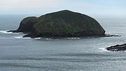 The western of the two islands, furthest from the coast
 -
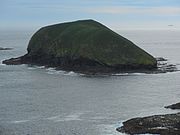 The eastern of the two islands, closest to the coast
 -
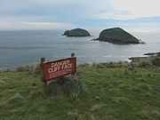 Cliff warning sign at Cape Grim, Tasmania, with The Doughboys in the background


See also
References
- ^ ISBN 0-7246-4816-X
- ^ Maunder, Sarah (2 April 2021). "'We've seen disrespect and ignorance': Tasmanian Aboriginal Centre to offer no more words for dual naming". SBS News. Retrieved 2 April 2021.
- ^ BirdLife International. (2011). Important Bird Areas factsheet: Hunter Island Group. Downloaded from "BirdLife International - conserving the world's birds". Archived from the original on 10 July 2007. Retrieved 20 April 2013. on 2011-07-09.