
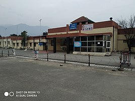
Udhampur
Udhampur | |
|---|---|
City | |
UTC+5:30 (IST) | |
| PIN | 182101 (Udhampur) |
| Telephone code | 91-1992 |
| Vehicle registration | JK-14 |
| Website | udhampur |
 | |
Udhampur (ˌʊd̪ʱəmpur) is a city and a
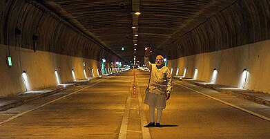
Main Tourist Attraction are Patnitop, Panchari Landhar , Ladha Dhar, Dudu Basantgarh, Ramnagar, Yug Dhar, Shivgarh, Sudhmahadev, Mantali International Yoga Center, Benesangh, Chenani Nashri Tunnel.
Geography
The district of Udhampur is located in the
Administration
The town of Udhampur is governed by Udhampur Municipal Committee with 22 municipal wards.
Notable personalities
- Martyr Captain Tushar Mahajan: Indian Army officer
- Padma Shri Romalo Ram
Climate
The city's climate is subtropical. Summer temperatures may exceed 40 degrees while temperatures below freezing have been recorded in winter. The annual rainfall is 130 cm, mainly in monsoons and winters. Central Udhampur rarely experiences snowfall, though its outer regions do occasionally. Due to changing climate patterns, heavier snowfall has been experienced in recent years. In 2011, there was about 15 cm snow. Heavy hailstorms with piles of hail can be experienced in February and March.
Agriculture
Vision of the Department: United and transformed agriculture to ensure economic prosperity and food security. To be recognized as global leader in agricultural advancement.
Agriculture is the mainstay of more than 80 per cent people in Jammu & Kashmir. Major food crops are wheat, paddy and maize. Barley, jowar and bajra are cultivated in some parts of the state. Agro-climatic condition of this state supports horticulture
Department of Agriculture Production and Farmers Welfare, Udhampur initiated Kisan Sampark Abhiyan, Daksh Kisan (learning management system) & Kisan Sathi (IT Dashboard for digitized services to farmers) in April 2023
| Climate data for Udhampur | |||||||||||||
|---|---|---|---|---|---|---|---|---|---|---|---|---|---|
| Month | Jan | Feb | Mar | Apr | May | Jun | Jul | Aug | Sep | Oct | Nov | Dec | Year |
| Record high °C (°F) | 24 (75) |
29 (84) |
33 (91) |
39 (102) |
40.5 (104.9) |
40.9 (105.6) |
41 (106) |
38 (100) |
32 (90) |
31 (88) |
29 (84) |
25 (77) |
41 (106) |
| Mean daily maximum °C (°F) | 18.8 (65.8) |
21.9 (71.4) |
26.6 (79.9) |
32.9 (91.2) |
38.3 (100.9) |
40.6 (105.1) |
35.5 (95.9) |
33.7 (92.7) |
33.6 (92.5) |
31.7 (89.1) |
26.8 (80.2) |
21.1 (70.0) |
30.1 (86.2) |
| Mean daily minimum °C (°F) | 1.2 (34.2) |
9.7 (49.5) |
13.6 (56.5) |
19.0 (66.2) |
24.4 (75.9) |
26.8 (80.2) |
24.5 (76.1) |
24.0 (75.2) |
23.0 (73.4) |
18.4 (65.1) |
12.6 (54.7) |
8.5 (47.3) |
17.7 (63.9) |
| Record low °C (°F) | −4.4 (24.1) |
−3 (27) |
3 (37) |
6 (43) |
7 (45) |
13 (55) |
13 (55) |
8 (46) |
12 (54) |
4 (39) |
2 (36) |
−3 (27) |
−4.4 (24.1) |
| Average rainfall mm (inches) | 50.0 (1.97) |
46.4 (1.83) |
53.2 (2.09) |
26.3 (1.04) |
16.0 (0.63) |
51.8 (2.04) |
283.4 (11.16) |
644.5 (25.37) |
123.9 (4.88) |
38.1 (1.50) |
11.9 (0.47) |
42.2 (1.66) |
1,387.7 (54.63) |
| Source 1: BBC Weather [failed verification] | |||||||||||||
| Source 2: [3] [failed verification] | |||||||||||||
| Climate data for Udhampur | |||||||||||||
|---|---|---|---|---|---|---|---|---|---|---|---|---|---|
| Month | Jan | Feb | Mar | Apr | May | Jun | Jul | Aug | Sep | Oct | Nov | Dec | Year |
| Record high °C (°F) | 24 (75) |
29 (84) |
33 (91) |
39 (102) |
40.5 (104.9) |
40.9 (105.6) |
41 (106) |
38 (100) |
32 (90) |
31 (88) |
29 (84) |
25 (77) |
41 (106) |
| Mean daily maximum °C (°F) | 18.8 (65.8) |
21.9 (71.4) |
26.6 (79.9) |
32.9 (91.2) |
38.3 (100.9) |
40.6 (105.1) |
35.5 (95.9) |
33.7 (92.7) |
33.6 (92.5) |
31.7 (89.1) |
26.8 (80.2) |
21.1 (70.0) |
30.1 (86.2) |
| Mean daily minimum °C (°F) | 1.2 (34.2) |
9.7 (49.5) |
13.6 (56.5) |
19.0 (66.2) |
24.4 (75.9) |
26.8 (80.2) |
24.5 (76.1) |
24.0 (75.2) |
23.0 (73.4) |
18.4 (65.1) |
12.6 (54.7) |
8.5 (47.3) |
17.7 (63.9) |
| Record low °C (°F) | −4.4 (24.1) |
−3 (27) |
3 (37) |
6 (43) |
7 (45) |
13 (55) |
13 (55) |
8 (46) |
12 (54) |
4 (39) |
2 (36) |
−3 (27) |
−4.4 (24.1) |
| Average rainfall mm (inches) | 50.0 (1.97) |
46.4 (1.83) |
53.2 (2.09) |
26.3 (1.04) |
16.0 (0.63) |
51.8 (2.04) |
283.4 (11.16) |
644.5 (25.37) |
123.9 (4.88) |
38.1 (1.50) |
11.9 (0.47) |
42.2 (1.66) |
1,387.7 (54.63) |
| Source 1: BBC Weather [failed verification] | |||||||||||||
| Source 2: [4] [failed verification] | |||||||||||||
Demographics
According to the 2011 Indian census, Udhampur urban area has a population of 91,366, of which 35,507 live in the Udhampur Municipal Council area, 48,508 live in Udhampur's out-growths, and 5,743 live in Rehambal.[1] Males constitute 60.2% of the population and females 39.8%.[1] The large male percentage is due to the army constituting a large part of the city's population. Udhampur has an average literacy rate of 91.5%. The dominant religion in the city is Hinduism.
| ||||||||||||||||||||||||||||||||||||
Education
This section needs expansion. You can help by adding to it. (August 2023) |
Schools
- Government Degree College[6]
- Government Degree College Chenani [1]
- Government Women College Udhampur
Transport
Road
Udhampur is located on National Highway NH-44, which is the only national highway that connects Srinagar to the rest of India. Bus services (both private and state owned) are the most common mode of public transportation to and from Udhampur. Frequent connections to the Kashmir Valley and Jammu are available. Taxi services are also available for going to Jammu and Srinagar and other nearby towns, and minibuses operate within the city.
Rail
Udhampur is connected to Jammu which is the winter capital of UT Jammu and Kashmir in India. The Uttar Sampark Kranti Express train from New Delhi was the first train to run on this link in 2005. More than a dozen long-distance trains either originate from Udhampur railway station or connect Udhampur to the rest of India. Commuter unreserved passenger trains link Jammu and Udhampur.
The project to connect Udhampur to the Kashmir valley by railway track is progressing. The railway line has been laid to Katra. Now Katra to Banihal track remains to be laid to complete the Jammu–Baramulla line.
The Northern Railway Construction Organization (Jammu–Baramulla line) is working on connecting Udhampur and Srinagar.
Air
Udhampur Air Force Station of the Indian Air Force (IAF) is located in Udhampur but it is not open for civilians. Jammu Airport is the nearest civilian airport.
Gallery
-
 Udhampur-Jammu highway
 -
-
-
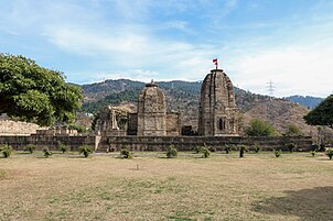
 Kirmachi Temples
 -

-
 Samadhi of Queen of Raja Suchet Singh
 -
-


See also
- Udhampur-Jammu highway
References
- ^ a b c d e A-4 Towns And Urban Agglomerations Classified By Population Size Class In 2011 With Variation Since 1901. Office of the Registrar General & Census Commissioner, Ministry of Home Affairs, Government of India (Report).
Class - II Population of 50,000 and 99,999 (Report). - ^ "Maps, Weather, and Airports for Udhampur, India". Retrieved 5 February 2017.
- ^ "Climatological Table, Period: 1971-2000", India Meteorological Department, Ministry of Earth Sciences, Government of India, archived from the original on 21 November 2011
- ^ "Climatological Table, Period: 1971-2000", India Meteorological Department, Ministry of Earth Sciences, Government of India, archived from the original on 21 November 2011
- ^ "Udhampur City Population". Census India. Retrieved 11 July 2021.
- ^ "GDC Udhampur organises workshop on 'Patent filing, Presentation of Innovative ideas'".
16. Pingla Mata Shrine — Pingla Mata Cave is situated in Village Pinger of Ramnagar Tehsil in Udhampur District.