
Upper Pond (Kaliningrad)
This article needs additional citations for verification. (December 2012) |
| Upper Pond | |
|---|---|
| Oberteich | |
artificial lake | |
| Basin countries | Russia |
| Surface area | 41.1 ha (102 acres) |
The Upper Pond (Russian: Верхний пруд) is a large artificial pond in northern Kaliningrad, Russia. It was known as the Oberteich while part of Königsberg, Germany, until 1945.
The pond is elevated 22 metres above the
History
The Upper Pond, then known as the Oberteich, was created in 1270
Quarters of Königsberg in the vicinity of the pond included Hinterroßgarten to the southeast, Hintertragheim to the southwest, Tragheimsdorf to the west, and Maraunenhof to the north. East of the Oberteich were gardens and the Königsberg horse racing track. Along its shores were public baths (Prussia Badeanstalt, KSC-Badeanstalt, Hansa-Badeanstalt), a military bath, and an angling club.
The pond was transferred from Germany to the Soviet Union following World War II in 1945. The German consulate is located along the northern shore of the modern Upper Pond.
Gallery
-
 Former restaurant Oberteichterasse in Königsberg
 -
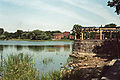 Upper Pond vicinity, ca. 1982. TheKaliningrad Amber Museumis in the background.


Notes
References
- Albinus, Robert (1985). Lexikon der Stadt Königsberg Pr. und Umgebung (in German). Leer: Verlag Gerhard Rautenberg. p. 371. ISBN 3-7921-0320-6.