
Vindelfjällen Nature Reserve
| Vindelfjällen Nature Reserve | |
|---|---|
wilderness area) | |
 | |
| Coordinates | 65°55′23″N 15°19′04″E / 65.923056°N 15.317778°E |
| Area | 562,772 hectares (2,172.87 sq mi; 1,390,640 acres; 5,627.72 km2)[1] |
| Established | 1974 |
| Visitors | 412,000 (in 2000) |
| Governing body | county of Västerbotten |
| Official name | Tärnasjön |
| Designated | 5 December 1974 |
| Reference no. | 29[2] |

The Vindelfjällen Nature Reserve (Swedish: Vindelfjällens naturreservat) is a nature reserve located in the municipalities of Sorsele and Storuman in Västerbotten County of Swedish Lapland. It is the largest natural reserve in Sweden and one of the largest protected areas in Europe, totaling 562,772 ha (approx. 5,628 km2).
Most of the reserve is made up of several Scandinavian Mountains, the main ones being Artfjället, Norra Storfjället, Ammarfjället and Björkfjället. Most of the landscapes of the Swedish mountains are represented. This ranges from the pronounced alpine character of Norra Storfjället, which includes the highlight of the reserve, the Norra Sytertoppen (1,768 m), to the plateau and plains near the base of the mountains. The differences in elevation highlight the diversity of rocks in the mountains. Among the mountains are the valleys and waterways of the Ume River drainage basin. This includes a portion of the Vindel River, after which the reserve is named. Towards the east, the elevation decreases and the mountains give way to the Lapland Plains.
This landscape diversity also includes biodiversity. The reserve covers the primary forests of the Nordic
The region has been populated since the end of the last
In addition to the inhabitants, the reserve sees considerable activity from tourists both in winter and summer. Hiking is one of the main activities, especially along the well known Kungsleden trail, which crosses the reserve along its length. The summer roads are also often used for cross-country ski trails or snowmobile trails in winter. Finally many ecotourism activities are offered by various tourism businesses. Besides tourism, traditional activities such as reindeer herding, by the Sami, and hunting and fishing are still practiced. Finally, the mountains are widely used for scientific research, which is facilitated by the presence of an on-site research station.
Toponymy
The word Vindel derives from the word vindill[what language is this?], which is similar to vända, the Swedish verb meaning to turn or change direction, probably in reference to the meandering nature of the Vindel river. In Swedish Vindelfjällen means 'the Vindel mountains', which is reasonable given that the Vindel River has its source in these mountains.
As in other areas of the Lapland mountains, the reserve has a number of Sami names. However, unlike the mountains further North, here they live among places with numerous Swedish names. For example, the words fjäll ('mountain'), sjö/vatten ('lake'), å/älv ('river'), etc. are frequently seen. This is a result of early Swedish settlers translating Sami names into Swedish as well as these settlers naming previously unnamed geographic features.
Geography

Location and boundaries
The reserve is located in the municipalities of
Relief

The Vindelfjällen reserve includes most types of Swedish landscapes; mountains, high plains to alpine peaks, passing through plateaus or rounded profile mountain ranges.
At the heart of the alpine region of the reserve is the Norra Storfjället mountain range. This mountain range includes the highest peaks, including Norra Sytertoppen, which from its height of 1,768 m is the highest point of the reserve as well as Västerbotten County. Other notable peaks of the mountain range are Måskostjakke (1,690 m) and Södra Sytertoppen (1685 m). The mountain range is cut down the middle by the narrow, deep valley of Syterskalet/Viterskalet, which is one of the icons of the reserve and is sometimes compared to the famous Lapporten by its symmetrical profile.[3]
The rest of the reserve consists of rolling hills and numerous emerging mountain ranges. At the western end of the reserve is that of Artfjället, culminating at 1,471 m. Artfjället consists of several sharp mountain ridges, as well as some rounded peaks. Centrally in the reserve is the Ammarfjället mountain range, with a peak plateau reaching its maximum at Rerrogaise (1,611 m). northeast, the Björkfjället mountain range forms the border of the reserve and the county. All in all, it has an average altitude of 800–900 m with the highest peak within the reserve being Vuorektjåkkå (1,245 m).[S 1]

Intersecting the various mountain ranges are several valleys and lowlands. One of the main valleys of the reserve is the Vindelälven River Valley, although the entire section south of Ammarnäs is largely excluded from the reserve. The northern section of the valley is quite sunken, surrounded by the Ammarfjället and Björkfjället mountain ranges and the valley widens when approaching Ammarnäs. The lowest point of the reserve, at 345 m above sea level, is located south of the valley, at the shores of Lake Storvindeln. At the center of the reserve is another large area of low altitude around Lake Tärnasjön. The terrain is flat, which has led to the formation of a vast network of wetlands.[4]
Finally, going east, in the sections added during the extension of the reserve in 1988, the altitude gradually decreases to reach the plain.[S 1]
Climate
The climate of the reserve has important contrasts. The western part is strongly influenced by humid air from the nearby
| Climate data for Vindel-Björkheden 1991-2020 normals (350m) | |||||||||||||
|---|---|---|---|---|---|---|---|---|---|---|---|---|---|
| Month | Jan | Feb | Mar | Apr | May | Jun | Jul | Aug | Sep | Oct | Nov | Dec | Year |
| Mean daily maximum °C (°F) | −6.8 (19.8) |
−6.0 (21.2) |
−1.0 (30.2) |
4.5 (40.1) |
10.4 (50.7) |
16.0 (60.8) |
19.0 (66.2) |
17.0 (62.6) |
11.5 (52.7) |
3.9 (39.0) |
−2.4 (27.7) |
−5.2 (22.6) |
5.1 (41.1) |
| Daily mean °C (°F) | −12.4 (9.7) |
−11.9 (10.6) |
−6.8 (19.8) |
−0.7 (30.7) |
5.0 (41.0) |
10.4 (50.7) |
13.4 (56.1) |
11.6 (52.9) |
6.8 (44.2) |
0.3 (32.5) |
−6.6 (20.1) |
−10.2 (13.6) |
−0.1 (31.8) |
| Mean daily minimum °C (°F) | −16.5 (2.3) |
−16.6 (2.1) |
−12.5 (9.5) |
−6.1 (21.0) |
−0.1 (31.8) |
5.6 (42.1) |
8.9 (48.0) |
7.1 (44.8) |
3.1 (37.6) |
−2.7 (27.1) |
−9.6 (14.7) |
−13.9 (7.0) |
−4.4 (24.0) |
| Average precipitation mm (inches) | 48.5 (1.91) |
37.0 (1.46) |
34.5 (1.36) |
27.6 (1.09) |
38.5 (1.52) |
66.5 (2.62) |
95.5 (3.76) |
79.8 (3.14) |
59.2 (2.33) |
51.7 (2.04) |
50.2 (1.98) |
49.0 (1.93) |
638 (25.14) |
| Source: NOAA[6] | |||||||||||||
Hydrography

The Vindelfjällen mountains have a rich river system flowing through it. The reserve covers a large part of the mountainous section of the Ume River watershed and protects the Vindel River, the main tributary of the watershed. The Vindel River is one of four "national rivers" with the Torne River, Kalix River and the Pite River: four great rivers of northern Sweden whose watershed is fully protected against the construction of dams and whose flow is currently unregulated. The Vindel River forms a large number of rapids upstream from Ammarnäs.
There are several other major rivers in the reserve. The Tjulån River originates at the Tjulträsk lakes and joins the Vindel River in Ammarnäs. The Juktån River passes the great lake Överst Juktan and continues outside the reserve to Ume River for a total length of 170 km. Finally the Tärnaån River originates at Lake Tärnasjön before joining into the Ume River just outside the reserve. The Ume River itself is located outside the reserve, between the Artfjället mountain ranges and the rest of the reserve[7] and unlike the rivers within the reserve, its waters have been regulated and used for hydroelectric power.
The reserve has several lakes, the largest of which often have an elongated shape, following the topography of the valleys. The two largest lakes are Överst-Juktan and Tärnasjön, both measuring about 20 km long. The Tärnasjön is particularly notable for the large number of small islands in the southern third of the lake, forming a mosaic of water and forest, which extends south of the lake to one of the largest wetlands reserves. Another vast wetland, Laivamyren, is located north of the lake. It covers no less than 20 km2 and includes the remains of the southernmost
Finally, water is found in the form of glaciers in areas where the altitude exceeds 1,600 m, or in other words, in the Norra Storfjället mountain range and more locally in Ammarfjället. Glacier names include Murtserglaciären, Måskonåiveglaciären, Norra Syterglaciären, Tärnaglaciären, Östra and Västra Skrapetjakkeglaciären, and Östra Syterglaciären, all of which have been studied since the late nineteenth century.[S 1]
Geology
Formation

Vindelfjällen is part of the Scandinavian Alps, reminiscent of the Caledonian belt. The latter is also the origin of the mountains of Scotland, Ireland, Greenland and Svalbard. The
The mountainous chain has been continuously eroded to form a peneplain. However, from about 60 Ma (Cenozoic), Scandinavian peneplane has undergone extensive tectonic uplift. Causes for this are not clear and several hypotheses have been proposed. One theory is the influence of the Icelandic plume could have raised the crust. Another hypothesis suggests that isostasy related to glaciations may have occurred. Whatever the cause, the uprising allowed the ancient channel to rise to more than 2000m at times.[A 2]
Geomorphology

While the Scandinavian Alps gradually increase altitude, erosion can negate this slow growth. While this includes

When glaciers retreated at the end of the last ice age, the large ice sheet to the east often survived longer than that of the mountain valleys. As a result, several lakes were formed as the water was trapped between the mountains to the west and glaciers to the east. Lakes such as Marsivagge Lake at Tjulträsk and Tärnasjön Lake have left alluvial terraces. For example, an alluvial terrace can be seen northwest of Tärnasjön at an altitude of about 700 m. The retreat of glaciers also spread
The area of Artfjället – Övre Ältsvattnet is found outside of the glacial formations, and represents a karst topography. Besides the underground sinkholes and streams, the most remarkable feature of these karst formations are the caves, which are among the largest in Sweden.[S 2]
Natural environment

The Vindelfjällen nature reserve includes almost all natural environments of the Scandinavian Alps. It is, according to the
Many of the species living in the reserve are included in the Habitats Directive and the Birds Directive of the European Union and / or are considered threatened at the national or international level, which justifies the classification of the reserve in the Natura 2000 network as important bird area. In addition, Lake Tärnasjön is classified as a Ramsar site (an area of 11 800 ha).[9]
Flora
Taiga
The Scandinavian taiga coniferous forest consists mainly of
The reserve did not initially include the taiga zone of the Juktån Valley, but the extension in 1988 brought in three new taiga areas: Giertsbäcksdalen, Matsorkliden and Kirjesålandet. These rich forests needed protection within the reserve and are especially valuable due to the nature of being primary forests, in other words, they have never been harvested. These primary forests are also important for numerous species, many of which are threatened by the intensive deforestation of the taiga. From the foot of the Swedish mountains and along the entire length of the chain, these forests create a valuable continuity, essential for the survival of several species here. Finally, while the remaining primary forests are often on
In terms of vegetation, the forests are home to a number of relatively rare or endangered species of
Birch forests

Birch forests are a characteristic feature of the subalpine Scandinavian Alps. These are a subspecies of
The moss-rich forests are the most common. Their undergrowth woods are dominated by mosses and blueberries (Vaccinium myrtillus) and low grasses. On the other hand, the prairie forests occur in areas where limestone is more common, such as the Artfjället mountain range or in sunny areas and with good access to water, such as on the north shore of Lake Stor-Tjulträsket, on the areas of the Vindel River valley facing south or near Aivak north of Lake Överst-Jukan. The undergrowth there are far richer, with diversity of grass species.[A 8]
Wetlands

The reserve has many wetlands usually in subalpine regions. This is overwhelmingly
Moorlands and meadows

The alpine mainly consists mainly of
The lower alpine level is also called the willow level because of the presence of several species of willows, such as the downy willow (
In the medium alpine level, often defined as the region above the limit of blueberries, the number of species is greatly reduced and the ground is increasingly frayed. Only the most resilient plants thrive; such as dwarf azaleas, crowberry, the blue heath (
The plants that can survive in the upper alpine level (beyond 1300 m) are predominantly limited to
Fauna
The levels of vegetation are also important for animals: species diversity is much greater at lower altitudes, especially in forests. However unlike plants, the animals are rarely restricted to a particular level.[A 11]
Mammals

Vindelfjällen home to many mammals characteristic of Swedish forests. A typical example is the moose (
Several species of mammals are more characteristics of alpine tundra, such as reindeer (Rangifer tarandus). As in the rest of the country, reindeer are all domesticated and belong to Sami villages, but live in a state of semi-freedom. In total there were over 20,000 reindeer in the Vindelfjällen mountain range. Another feature of the Scandinavian tundra lemming species is the Norway lemming (Lemmus lemmus). Its fame rests notably on its periodic population explosions. Indeed, every four years on average, the number of these rodents increases dramatically and will invade large areas before quickly dying off. Favorable weather conditions and good access to food are the most likely reasons for the sharp population increases. Their mass death is less well understood, perhaps related to the decrease in vegetation caused by their excessive consumption or the spread of epidemics among the population. Regardless, this phenomenon is extremely important for the entire ecosystem of the mountain. This is particularly the case for the most symbolic animal of the Reserve; the arctic fox. These foxes breed almost exclusively in years of lemming population explosion. There are only about 200 arctic fox in the Scandinavian Alps, and is therefore classified as critically endangered in Sweden. Vindelfjällen is one of the most important areas of all the mountains for this species, and it is actively protected. The Björkfjället mountain range is one of the best areas of Vindelfjällen for these small canines, but they are present in the Artfjället mountain range as well.[12][A 11]
Birds
The Vindelfjällen nature reserve is a nesting site for many species of birds, due to its wide variety of habitats, but especially its many wetlands, including in particular those around Lake Tärnasjön and in the Marsivagge Valley. The Marsivagge Valley alone is considered a nesting site for about 120 different species.[A 12]
In these wetlands include several species of
The lesser white-fronted goose (
The wetlands are not the only places where there are birds in the reserve. Regular inventories conducted in Tjulträsk Valley show that between 400 and 500 pairs of birds nest in one square kilometer of birch forests, half of which are the willow warbler (
History
Prehistory and Sami immigration
The first humans arrived in the mountains after the ice retreated at the end of the last
Among the remains, there are also broader foundations than traditional Sami dwellings, the Sámi legends associate these with a Stallo, an evil giant. Recent studies show that this is actually the oldest known Sami settlement. In the reserve, these large foundations are often located near the traps. For example, there are some of these at Vindelkroken and several near Lake Överuman. The stallos are often described as stupid but have superhuman strength. There is a huge stone placed on some small pebbles on top near Lake Giengeljaure named stalostenen, which literally means 'stone Stallo'. Legend dictates that a Stallo would have placed a stone here to prove his strength.[A 14]
The reserve has a large number of places the Sami consider sacred, also called Sieidi. These sacred places can be spotted in Sami place names. The words Ailes, Pass, page, Saivo, or Akka, which appear in several place names are sacred words. For example, a wooden idol, now on display at the Nordic Museum, was found in a rock hole near Lake Överst-Juktan, near a river named Ailesjokk. The hole in question was actually a place where the Sami were accustomed to making sacrifices of wood or other animal bones. A similar site is Rosapakte, east of Lillfjället near Lake Överuman.[A 14]
There are likely many graves and sacred sites that are not known, as the Sami likely wanted to protect those sites from plundering.
Since the twentieth century, the way of life of Samis has evolved rather quickly. One of the changes is the abandonment of several kata used in the past during the transhumance between sites of overwintered and summer pastures sites. These rudimentary abandoned buildings were gradually taken over by nature and have become difficult to notice, however some have been restored to witness the traditional Sami life.[A 15]
Swedish colonization

Since the early eighteenth century, Swedes began to arrive in the area and settle in the valleys. There were however no villages until the nineteenth century, e.g. villages were created in the area around the lake Stor-Laisan Ammarnäs in 1830. The first house was built in 1826, and in 1850 the village was already well-formed. This colonization was encouraged by the
Many paths now used as hiking trails were originally communication paths for mountain dwellers. For example, the priest who officiated at the Jillesnåle chapel also had to travel to Tärnaby chapel, 70 km away, and officiate there. Due to the lack of road, a path was created between the two churches. This path through the south of the reserve still exists today. Another example is a path that starts at Ammarnäs and follows the Vindel River valley then joins Vindelkroken and then crosses the Norwegian border to
Protection of the area
The first proposal of a protection of the area occurred in 1930 when Kirjesålandet was proposed to become a national park, but did not occur. In the 1950s, hydroelectricity developments were building their reservoirs in the country (see also: energy in Sweden), but already concerns were being raised against the environmental impact of these power plants. In particular, there were heated discussions about the developments on the Ume River and Vindel River. This led in 1961 an agreement called the "peace of Sarek" (Sarek freden i) that prevented development on some rivers of the Vindelälven and in exchange gave freedom to develop the other rivers, including the Ume River. The idea also grew to protect any section of the mountainous Vindelälven watershed[S 6][A 17] Under this project, the reserve, called the Reserve of Vindel-Laisfjällen (after the Vindel River and the Laisälven, its main tributary) would extend over 7,400 km2 of which 4,800 km2 in the county of Västerbotten and the remainder in the county of Norrbotten. In 1973, a working group composed of representatives of the counties and Naturvårdsverket was formed, but Norrbotten County did not join. Eventually, only the portion included in the county of Västerbotten was protected under the name Vindelfjällen on February 25, 1974 and was confirmed by the government in July 1975. The reserve protection plan was finally published in 1978. The famous hiking trail Kungsleden then stretched between Hemavan and Ammarnäs in connection with the creation of the reserve.[17]
In the 1980s, Naturvårdsverket (the environmental protection agency of Sweden) managed a large national inventory of the primary forests, and issued a report in four years later. Some areas of primary forest had already been inventoried to be included in the Vindelfjällen reserve, so it was natural that on January 25, 1988, the reserve was extended to more than 5500 km2 with the addition of primary coniferous forests Kirjesålandet, Matsorliden and Giertsbäcksdalen. In 1993, the entire Vindel River was finally declared a national river (Nationalälven), permanently protecting it and all its tributaries against any hydroelectric development. Finally, the entire reserve was included in the Natura 2000 network.
In their second direction plan of the national parks, published in 2008, Naturvårdsverket proposed to change the status of the nature reserve by transforming it into a national park. The national park status is the highest level of nature protection under Swedish law. In 2007, the municipal council of the municipality of Sorsele had expressed its approval of a preliminary study on the change, but numerous residents disagreed through a petition. This caused a new vote in 2008, and this time the municipal council gave their disagreement with the preliminary study. The reason for their refusal was that many people had concerns that the stricter statute would prevent many activities, such as snowmobiling, hunting and fishing. In contrast, people favorable to the project believed that the National Park status would offer greater international recognition and thus attract more tourists. In addition, the highest protection also prevent mining in the area. In fact, the Canadian business Blackstone Nickel had asked for an exploratory permit for drilling in the reserve. The permit was granted in 2009, as the original rules of the reserve had not taken this possibly into account. Because of the problems that were created by the drilling on the Sami reindeer herds, the company was ordered to compensate the farmers, but as of March 2013, it had still not paid.[18]
Management and regulation
In Sweden, the creation and management of nature reserves is the responsibility of municipalities and/or counties. In this case, the county of Västerbotten is responsible for the management of Vindelfjällen. The entire area of the reserve belongs to the state.[10]
The rules establishing what is allowed and what is forbidden varies from one reserve to another
Management measures are determined at the creation of the reserves and updated at regular intervals (typically several years).[20] For the Vindelfjällen reserve, the county provides a detailed inventory of large mammals and birds; done annually for some species.[22] Similarly, coniferous forests and birch trees as well as other "plants of interest" are inventoried regularly.[S 8] The county also ensures that tourism infrastructure is well maintained.[S 8]
Activities
Tourism

The number of tourist visiting the reserve has significantly increased since the creation of the reserve.
The main entry points for visiting the reserve are the villages of Ammarnäs or Hemavan.
At its inception, the reserve had very little tourist infrastructure, and one of the stated objectives with this creation was to improve accessibility. In 1978, Swedish architect Tore Abrahamsson presented a report to the administration of Västerbotten county in which he recommended the construction of trails and chalets. From this, many projects came to life.[S 9] For example, cottages (stuga) were built along the Kungsleden trail in 1983 and in 2001, between 1993 and 1994 other cottages (koja) were within the area of the reserve that was added in 1988. In 1984, a Naturum (interpretive nature center) was built at Ammarnäs and a second one in 2004 in Hemavann.[25]

Nowadays, the reserve has an extensive trail system, totaling about 600 km.[S 10] The best known trail is the Kungsleden trail, but Drottningleden trail (south of Hemavan) and Vindelvaggileden trail (along the Vindel River valley) are also well known.[S 10] The trails are made of planks in the wetland area and numerous bridges.[S 11] In all, there are more than 40 bridges in the reserve, the most notable are the successive bridges that cross Lake Tärnasjön at the southern archipelago; sometimes called the Vindelfjällen Golden Gate Vindelfjällen.[S 11] Most trails are also snowmobile trails in winter, but there are also use specific paths.[21] To enable hikers and snowmobile drivers to spend the night in the reserve, many cottages were built in the reserve. There are three types of cottages: one is a paid stuga cottage to spend the night and often contains some equipment (emergency phone, kitchen, etc.), the koja is a free cabin to spend the night, but not equipped, and finally a rudimentary rastskydd is a small cottage to take a short break.[S 12] In 2012, the reserve has fifteen stuga and eight koja (for a total capacity of 250 people) as well as seven rastskydd.[S 10] The main stuga (sleeping up to 30 people each) are located along the Kungsleden trail, but there are also several other trails nearby. The koja are mostly located in coniferous forests, and are usually not connected to the network of trails.
-
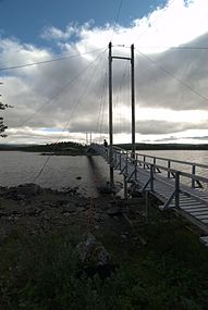 The successive bridges south of Lake Tärnasjön
 -
 Sauna complex at Tärnasjöstugorna
 -
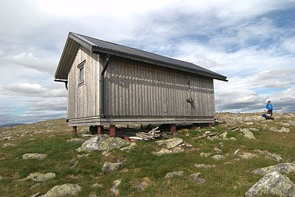 A shelter (Rastskydd) to Juovatvaratje along the Kungsleden trail


Other
Besides tourism, the main activity of the reserve is reindeer herding by Sami, and one of the reserve 's objectives is to protect this traditional activity. The reserve is located on the western section of the three territories known as sameby (literally
Hunting and fishing are also important activities in the reserve, both for local people for their own consumption as well as for leisure. The latter is partly organized by tourism enterprises.[S 7]
Finally, scientific research is an activity that is growing in the reserve. This became more developed in the 1950s as a consequence of hydroelectric developments. During this time, scientists began a thorough inventory of the wealth of flora and fauna in the Valley Vindelälven.[S 14] In 1963, the University of Lund set up the project LUVRE (Lund University Vindel River Expedition: dispatch of the Vindel River by Lund University), that helped lead to the official protection of the river.[S 14] Scientists today continue to regularly inventory flora and fauna within the framework of this project. Another important project, SEFALO, began in the reserve in the 1980s. It was led by the University of Stockholm with the purpose of ensuring the preservation of the polar fox.[S 14] The research was conducted to understand the many factors the might explain why a species fails to flourish in the Scandinavian Alps, despite protection.[26] The project has since expanded across the Scandinavian Alps.[26] In 1994, a research station was built to house Ammarnäs researchers.[S 8]
Notes
- Abrahamsson, Tore (1989). Detta är Vindelfjällen : vandringar, dagsturer, geologi, fauna, flora. Stockholm: Bonnier. ISBN 91-34-51043-5.
- Staafjord, Tomas (2012). Vindelfjällens naturreservat: Grundutredning om natur, kultur, nyttjande och förvaltning. Umeå: Comté de Västerbotten.
References
- ^ "Listing of acreage – December 31, 2011" (XLSX). Land Resource Division, National Park Service. Retrieved 2012-03-08. (National Park Service Acreage Reports)
- ^ "Tärnasjön". Ramsar Sites Information Service. Retrieved 25 April 2018.
- Svenska Turistföreningen(consulté le 1er mars 2013)
- ^ "Habitat types". Vindelfjallen.se. Retrieved December 11, 2018.
- ^ (sv)"Normal sista dag med snötäcke, medelvärde", sur Institut suédois de météorologie et d'hydrologie (SMHI) (consulté le 1er mars 2013)
- ^ "NOAA / WMO averages 1991-2020 Vindel-Björkheden". SMHI / NOAA. Retrieved 28 August 2023.
- ^ données recueillies sur cette carte
- ^ "Natura 2000". Vindelfjallen.se. Retrieved December 11, 2018.
- ^ "The Annotated Ramsar List: Sweden", sur Convention Ramsar (consulté le 2 mars 2013)
- ^ a b c d (sv) "Bevarandeplan Vindelfjällen SE0810080", sur Länsstyrelsen i Västerbotten, 2008 PDF
- ^ "Vegetation types". Vindelfjallen.se. Retrieved December 11, 2018.
- ^ (sv) Naturvårdsverket, Åtgärdsprogram för fjällräv 2008–2012, 2008 (lire en ligne) PDF
- ^ "Birds". Vindelfjallen.se. Retrieved December 11, 2018.
- ^ "Vaders 1". Vindelfjallen.se. Retrieved December 11, 2018.
- ^ "Vaders 2". Vindelfjallen.se. Retrieved December 11, 2018.
- ^ "Raptors and owls". Vindelfjallen.se. Retrieved December 11, 2018.
- ^ (sv) Claes Grundsten, Vandra Kungsleden : från Abisko till Hemavan, Stockholm, Prisma, 2008, 221
- ^ (sv) "Gruvletare försvann efter krav om ersättning", Västerbottens-Kuriren, 11 mars 2013 (lire en ligne)
- ^ (sv) "Naturreservat - vanlig och stark skyddsform", sur Naturvårdsverket (consulté le 1er avril 2013)
- ^ a b (sv) "Förordning (1998:1252) om områdesskydd enligt miljöbalken m.m.", sur Notisum (consulté le 1er avril 2013)
- ^ a b c d e (sv) "Vindelfjällens naturreservat", sur Länsstyrelsen i Västerbotten (consulté le 1er avril 2013) PDF
- ^ p. 97-102
- ^ a b c "How to get here", sur Vindelfjällen (consulté le 24 mars 2013)
- ^ "Flights to Hemavan", sur NextJet (consulté le 24 mars 2013)
- ^ "Cabins", sur Vindelfjällen (consulté le 24 mars 2013)
- ^ a b (sv) "Fjällrävsforskning på Stockholms universitet", sur Zoologiska institutionen i Stockholm universitet (consulté le 1er avril 2013)
Bibliography
- Grundsten, Claes (1998). På fjälltur : Vindelfjällen : turbeskrivningar. Stockholm: Rabén Prisma. ISBN 91-518-3346-8.
- Abrahamsson, Tore (1989). Detta är Vindelfjällen : [vandringar, dagsturer, geologi, fauna, flora]. Stockholm: Bonnier. ISBN 91-34-51043-5.
- Nyström, Hans (2012). Där Vindelfjällen tar vid. ISBN 978-91-7331-460-2.
External links
| Authority control databases: National |
|---|