
Vratnik (Sarajevo)
Vratnik
Вратник | |
|---|---|
Neighborhood | |
UTC+2 (CEST) | |
| Area code | +387 |
Vratnik (
History
Developed by the Ottomans since 16th century, its core was redeveloped into in the
The Walled city of Vratnik represents urban core within the wider neighbourhood of Vratnik and is designated as a national monument of Bosnia and Herzegovina since 2005.[1][2]
Vratnik is of Slavic origin and is derived from the form Bratnik, which appears in the Turkish documents in the second half of the 15th century. Others believe, Vratnik name comes from the word "vrata" (gateway or door). The old Vratnik fort is associated with its location alongside the roads by which persons and goods entered the town from east at that time. The "Imperial Road" (Carska Džada), road from Sarajevo via Višegrad to Istanbul, led over Vratnik for centuries.[3]
Up until the brief but devastating terror-raid of
- Inside Vratnik walls lies an old town
-
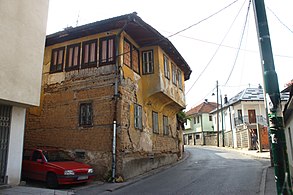 Old house of Bosnian architecture
 -
 Tight street spaces
 -
 Old Vratnik town architecture
 -
 Mišćina mosque (2010)
 -
 Fortification walls and Sirokac Tower (May 1987)


.jpg)
Heritage


The Walled city of Vratnik represents urban core within the wider neighbourhood of Vratnik. Since 2005 the
It includes features such as Visegrad Gate as the main entry point to a town and is one of the three city gates (towers) in the Vratnik Old Town (The old Vratnik fort) with the other two being Širokac Gate and Ploča Gate. It was built between 1727 and 1739, in limestone and a special Bosnian stone "hreša" with roof shingles. Traffic went east via the main road towards Visegrad (thus the name) and continued further to the east towards Istanbul.[4]
Ploča Gate is transformed into the Alija Izetbegović Museum, in commemoration to a former first president of Bosnia and Herzegovina, Alija Izetbegović, and opened on 19 October 2007.[5]
-
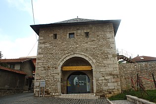 Ploca Tower, now Museum Alija Izetbegović
 -
 Širokac tower-gate


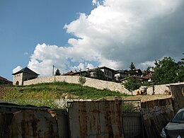
Along the perimeter walls thera are several forts, such as Bijela Tabija (transl. White Fortress), Žuta Tabija (transl. Yellow Bastion and smaller bastions. Bijela Tabija is a cannon bastion/fortress which also served to accommodate soldiers. It is assumed to have been built at the site of a small medieval town "Hodidjed" (central fortress of the Vrhbosna Parish). The fortress overlooks Sarajevo with the panoramic views of the eastern entrance to Sarajevo, the Miljacka River canyon and the city itself.[4][6]
Žuta Tabija is a cannon fort at Jekovac part of the neighborhood, close to the Jajce Barracks and the Jekovac water reservoir. It served as one of the defense points against the
Other important forts are Strošićka Tabija (transl. Strošićki Bastion),[1] Tabija na Ravnim Bakijama (transl. Bastion on Ravne Bakije),[1] Tabija na Zmajevcu (transl. Bastion on Zmajevac).[1]
-
 Žuta Tabija
 -
 Bijela Tabija from Mt. Trebević
 -
 Vratnik walls
 -


Other features

Jajce barracks is the name of the former
See also
References
- ^ a b c d e kulturno-nasljedje.com (16 September 2015). "Old town Vratnik (history with maps)".
- ^ a b Commission to preserve national monuments (16 September 2015). "Old Vratnik Fort, the architectural ensemble". kons.gov.ba. Archived from the original on 3 March 2016. Retrieved 16 September 2015.
- ^ sarajevotimes.com (16 September 2015). "Vratnik: Neighborhood that Proudly Represents the Sunny Side". sarajevotimes.com. Retrieved 16 September 2015.
- ^ a b c "Vratnik town walls with tower-gates". sarajevo-tourism.com. 16 September 2015.
- ^ "Museum Alija Izetbegovic". visitmycountry.net. Retrieved 2 March 2023.
- ^ "Žuta tabija | Furaj.ba". www.furaj.ba. Archived from the original on 8 July 2014.
- ^ "Jajce Barracks Military Complex, Sarajevo". Archived from the original on 6 March 2016.

| Authority control databases: National |
|---|