
Waterville, Washington
Waterville | ||
|---|---|---|
FIPS code 53-76510 | | |
| GNIS feature ID | 1527848[3] | |
| Website | Town of Waterville | |
Waterville is a town in and the
History
The area Waterville occupies was settled in 1883 by A.T. Greene. In 1886 he successfully encouraged land donations and the town was established under the name "Jumper's Flat." After the discovery of a large water reservoir underneath Greene's farm, the town was renamed to "Waterville."[5]
Geography

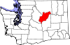
Waterville is located at 47°38′52″N 120°4′22″W / 47.64778°N 120.07278°W (47.647889, −120.072779).[6]
According to the United States Census Bureau, the town has a total area of 0.87 square miles (2.25 km2), all of it land.[7]
Like most of Eastern Washington, Waterville experiences a semi-arid climate (Köppen BSk) with cold, moist winters and hot, dry summers.
At 2,625 ft (800 m), Waterville has the highest elevation of any incorporated city or town in Washington.
| Climate data for Waterville, Washington | |||||||||||||
|---|---|---|---|---|---|---|---|---|---|---|---|---|---|
| Month | Jan | Feb | Mar | Apr | May | Jun | Jul | Aug | Sep | Oct | Nov | Dec | Year |
| Record high °F (°C) | 66 (19) |
59 (15) |
74 (23) |
88 (31) |
96 (36) |
102 (39) |
105 (41) |
104 (40) |
97 (36) |
84 (29) |
68 (20) |
56 (13) |
105 (41) |
| Mean daily maximum °F (°C) | 30.3 (−0.9) |
36.1 (2.3) |
45.7 (7.6) |
57.1 (13.9) |
66.2 (19.0) |
73.5 (23.1) |
82.7 (28.2) |
81.6 (27.6) |
72.0 (22.2) |
58.3 (14.6) |
41.1 (5.1) |
31.9 (−0.1) |
56.4 (13.6) |
| Mean daily minimum °F (°C) | 14.8 (−9.6) |
18.9 (−7.3) |
26.7 (−2.9) |
34.1 (1.2) |
41.0 (5.0) |
47.0 (8.3) |
52.5 (11.4) |
52.3 (11.3) |
44.6 (7.0) |
34.9 (1.6) |
25.1 (−3.8) |
17.6 (−8.0) |
34.1 (1.2) |
| Record low °F (°C) | −30 (−34) |
−25 (−32) |
−10 (−23) |
11 (−12) |
16 (−9) |
29 (−2) |
32 (0) |
29 (−2) |
15 (−9) |
4 (−16) |
−21 (−29) |
−33 (−36) |
−33 (−36) |
| Average precipitation inches (mm) | 1.44 (37) |
1.10 (28) |
0.82 (21) |
0.69 (18) |
0.96 (24) |
0.93 (24) |
0.39 (9.9) |
0.49 (12) |
0.53 (13) |
0.75 (19) |
1.49 (38) |
1.69 (43) |
11.28 (286.9) |
| Average snowfall inches (cm) | 11.4 (29) |
8.2 (21) |
3.4 (8.6) |
0.7 (1.8) |
trace | 0.0 (0.0) |
0.0 (0.0) |
0.0 (0.0) |
trace | 0.4 (1.0) |
6.6 (17) |
14.0 (36) |
44.9 (114) |
| Source: [8] | |||||||||||||
Demographics
| Census | Pop. | Note | %± |
|---|---|---|---|
| 1890 | 293 | — | |
| 1900 | 482 | 64.5% | |
| 1910 | 950 | 97.1% | |
| 1920 | 1,198 | 26.1% | |
| 1930 | 856 | −28.5% | |
| 1940 | 939 | 9.7% | |
| 1950 | 1,013 | 7.9% | |
| 1960 | 1,013 | 0.0% | |
| 1970 | 919 | −9.3% | |
| 1980 | 908 | −1.2% | |
| 1990 | 995 | 9.6% | |
| 2000 | 1,163 | 16.9% | |
| 2010 | 1,138 | −2.1% | |
| 2020 | 1,134 | −0.4% |
2010 census

As of the
There were 449 households, of which 30.3% had children under the age of 18 living with them, 57.5% were married couples living together, 9.6% had a female householder with no husband present, 3.3% had a male householder with no wife present, and 29.6% were non-families. 23.8% of all households were made up of individuals, and 12.9% had someone living alone who was 65 years of age or older. The average household size was 2.51 and the average family size was 2.98.
The median age in the town was 43.3 years. 22.8% of residents were under the age of 18; 7.4% were between the ages of 18 and 24; 21.5% were from 25 to 44; 30.5% were from 45 to 64; and 17.9% were 65 years of age or older. The gender makeup of the town was 50.4% male and 49.6% female.
2000 census
As of the
There were 443 households, out of which 33.7% had children under the age of 18 living with them, 62.6% were married couples living together, 6.0% had a female householder with no husband present, and 27.3% were non-families. 24.0% of all households were made up of individuals, and 13.9% had someone living alone who was 65 years of age or older. The average household size was 2.65 and the average family size was 3.17.
In the town, the age distribution of the population shows 28.8% under the age of 18, 5.8% from 18 to 24, 23.4% from 25 to 44, 24.2% from 45 to 64, and 17.7% who were 65 years of age or older. The median age was 40 years. For every 100 females, there were 91.6 males. For every 100 females age 18 and over, there were 93.5 males.
The median income for a household in the town was $36,458, and the median income for a family was $47,386. Males had a median income of $35,375 versus $23,375 for females. The
Education
Waterville School District operates the town's public school.
See also
- Great Northern Railway: Mansfield Branch (1909–1985)
References
- ^ "2019 U.S. Gazetteer Files". United States Census Bureau. Retrieved August 7, 2020.
- ^ a b "2020 Census State Redistricting Data". census.gov. U.S. Census Bureau. Retrieved May 4, 2022.
- ^ "US Board on Geographic Names". United States Geological Survey. October 25, 2007. Retrieved January 31, 2008.
- ^ "Find a County". National Association of Counties. Retrieved June 7, 2011.
- ISBN 0-917048-57-1.
- ^ "US Gazetteer files: 2010, 2000, and 1990". United States Census Bureau. February 12, 2011. Retrieved April 23, 2011.
- ^ "US Gazetteer files 2010". United States Census Bureau. Retrieved December 19, 2012.
- ^ "WATERVILLE, WASHINGTON (459012)". Western Regional Climate Center. Retrieved March 22, 2018.
- ^ "U.S. Census website". United States Census Bureau. Retrieved December 19, 2012.
External links
 | ||||
Towns | ||||
| Unincorporated communities | ||||
| Ghost towns | ||||
| Footnotes | ‡This populated place also has portions in an adjacent county or counties | |||
| International | |
|---|---|
| National | |
| Other | |