
Wikipedia:Graphics Lab/Map workshop/Archive/Aug 2013
Stale
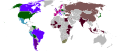
The Full Size of Tibet


Article(s): List of active separatist movements in Asia
Request:
- The Tibet shown on the map of independence movements in China is just the Autonomous Region, Tibet was historically much bigger than this, but the rest of it has been incorporated into other Chinese provinces. Please change this map so that it shows the whole of historical Tibet, based on the map found on the page http://www.tibetnetwork.org/tibet-at-a-glance/ and the other maps I have placed here.
Graphist opinion(s): Nothing in Category:Maps of Tibet will do? Kmusser (talk) 02:21, 3 June 2013 (UTC)
- I have a map of China made in Sweden in the 1930s, Tibet it shows is something average between the modern autonomous region and Tibetan nationalists' claims. Probably it is the most neutral point of view. Hellerick (talk) 04:41, 3 June 2013 (UTC)
This map is supposed to show areas of China that have independence movements, so the whole of the area that was Tibet should be shown, since all of it is claimed by the Tibetan independence movement. All foreign organizations (e.g. Free Tibet, Friends of Tibet that support Tibet will back up the claims of that movement that all that land is theirs. — Preceding unsigned comment added by 154.50.194.126 (talk) 09:28, 3 June 2013 (UTC)
Description of the battle of Lesnaya
Article(s): Battle of Lesnaya, Great Northern War, Adam Ludwig Lewenhaupt etc.
Request:
- The article of the battle of Lesnaya is in great need of a map description of the battle, as different "locations" and "key-points" are described in the text but none available map can be found to support these. There's a map here which could be very useful for increased quality of the article. However, I'm probably not allowed to publish it here on Wikipedia due to its copyrights. What I'm asking is if anyone would be happy to help me make this map wiki-styled, to use in the following articles; Battle of Lesnaya, Great Northern War, Adam Ludwig Lewenhaupt etc. The map was first published in the book "Vägen till Poltava" (Swedish). Imonoz (talk) 11:12, 6 June 2013 (UTC)
Missing LGA in South Australia
-
 All LGAs in Australia
 -
 LGAs in South Australia with Yalata highlighted
 -
 Locator map of South Australia with LGA boundaries marked


Article(s): Local government in Australia
Request:
- Yalata (far western South Australia, on the ocean) is missing from the nationwide map; please add it. The second map shouldn't be modified; I've only given it so you don't have to figure out Yalata's boundaries. And while you're at it, could you add Yalata to the third map? Right now shows just a circle in the vicinity. Nyttend (talk) 22:51, 8 June 2013 (UTC)
Graphist opinion(s):
No consistent map of languages of Europe
-
 Rectified Languages of Europe map.png
 -
 Languages of Europe map.png
 -
 Languages en3.PNG


Article(s): Languages of Europe
Request:
- There is no single consistent error-free map of the languages spoken in Europe. The three most prominent ones all show inconsistencies between each other, and none gives a credible, or even a verifiable source of data. I expect it would be a major undertaking to construct and maintain such a map, but maybe this is a good time for the WikiProject Maps to start one? -- Nelg (talk) 18:01, 9 June 2013 (UTC)
Graphist opinion(s):
Broadway
Article(s): Broadway, New York City
Request:
- A street map is requested for the Broadway street throughout Manhattan and Bronx, similar to http://i.imgur.com/3uF44rF.png . Personally I would use the google maps one i just linked to but I think the licensing for it isn't right, or something like that. So an NYC streetmap with Broadway highlighted, please. -- Sir Rcsprinter, Bt (state the obvious) @ 21:04, 11 June 2013 (UTC)
Graphist opinion(s):
Update needed on Societal attitudes towards homosexuality
-
 Current image

Article(s): Various articles on various Wikipedia's
Request:
- The current image shows the results of 2007 study. PEW has a new 2013 study. [1] Cavann (talk) 18:50, 13 June 2013 (UTC)
Graphist opinion(s):
Map of a planned new university campus
Article(s):
Request:
- Please create a map of the campus area of the planned new university in Kimberley, Northern Cape, South Africa. The source is the image on this page. Thanks -- Roger (Dodger67) (talk) 18:15, 26 May 2013 (UTC) Just a question - Does anybody still work here? Roger (Dodger67) (talk) 09:09, 21 July 2013 (UTC)
Graphist opinion(s):
Resolved
Stray lines in an SVG
-
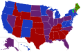 US Senators' party affiliations

Article(s): 113th United States Congress and four others
Request:
- Please remove the purple lines in the white areas south of Arizona and south of Florida. 2001:18E8:2:1020:8C30:A6BE:F890:A67 (talk) 14:54, 3 July 2013 (UTC)
Graphist opinion(s): I tried, they disappear when viewed at full resolution and they aren't in the SVG code, there's nothing there that's not in the file for the 112th Congress. I don't know what's making them. Kmusser (talk) 16:34, 5 July 2013 (UTC)
Turn Jvuo1942 en.png into SVG
- request moved from Illustration workshop
-
 Mihailović's territory according to Time magazine

Article(s): es:Chetniks
Request:
- I would be grateful if someone can come up with an SVG version of the map above. The same base map is being used in a few WWI maps and once the basic map is available I think I could turn a few of them into SVG too (and make translations for the Spanish wikipedia, my main goal). I could create the new SVG version myself but I am afraid I do not have the time just now so any help is really welcome. Thank you!-- Rowanwindwhistler (talk) 19:25, 24 July 2013 (UTC)

Would it be okay, or you need something less flashy? Hellerick (talk) 06:48, 30 July 2013 (UTC)
- It is perfect! I can always change the colours if needed (unlikely they look ok to me). The point is that I can easily translate this map and use it as a base to generate SVG versions of those using the same base map if necessary. Thank you very much, Hellerick!--Rowanwindwhistler (talk) 07:27, 30 July 2013 (UTC)
Virgin Atlantic destinations
-
 Blank world map

Article(s): Virgin Atlantic
Request:
- Please can somebody create a map of Virgin Atlantic destinations, in the same was as Virgin Atlantic destinations lists all destinations, and it would be appreciated if destination countries could be coloured in red. Thank you. -- Cloudbound (talk) 18:17, 21 July 2013 (UTC)]
Graphist opinion(s):
- I am interested in taking this request, but I would like you to answer the following questions before I start working:
- What colour do want the UK to be, if all the rest are red?
- What colour do want the seasonal destinations to be? (EDIT: seems like only Canada fits this)
- --talk / contribs 18:34, 30 July 2013 (UTC)]
- I'll just take this on myself, with blue as UK, and Canada like the rest. talk / contribs 03:45, 31 July 2013 (UTC).]
- Is this OK? talk / contribs 06:29, 31 July 2013 (UTC)]
- That's great. Thank you very much. Cloudbound (talk) 21:43, 31 July 2013 (UTC)
- Is this OK?
- I'll just take this on myself, with blue as UK, and Canada like the rest.
Updates to File:Ir2011map2.png

Article(s): Israel Railways and others
Request:
Can someone please create an updated map of the Israel Railways system? File:Ir2011map2.png can serve as a basis for it. The necessary changes are:
- The "Yavne" station on the Ashkelon-Binyamina line (blue on the current map) should be called "Yavne East"
- The Yavne West-Hod HaSharon line (red on the current map) needs to be extended to the Ashdod and Ashkelon stations.
- The HaRishonim-Tel Aviv line (purple on the current map) needs to be extended to the Tel Aviv Savidor Central station.
- The use of the colors on the original map has no basis in reality - it should probably be changed for copyright reasons.
The official map of Israel Railways, which includes the English names for the stations, can be found at http://www.rail.co.il/HE/Tickets/Map/Pages/map.aspx - so you can see that the information I gave you is correct. עוד מישהו Od Mishehu 16:11, 19 August 2013 (UTC)
Graphist opinion(s):
 Question: (1) You said Tel Aviv Savidor Central but both maps refer to it as Tel Aviv Savidor Center. I'll take it the maps are correct and you made a typo?
- Question: (2) Why is there an un-named station marker between Ben Gurion Airport and Paatei Modi'in on the png (not on the map on the official site)?
- and svg and make your amendments, probably finish it in a day or so. Begoon talk 16:37, 19 August 2013 (UTC)]
- Yes, "Savidor Center" is right - I misremembered the translation when I wrote this up. (Either way, in Hebrew it's Merkaz).
- The unmarked station is probably a mistake - there is no station there. עוד מישהו Od Mishehu 17:07, 19 August 2013 (UTC)
- Great - thanks for the quick answers - it's late here, so I'll start it tomorrow - should be pretty straightforward. Cheers. Begoon talk 17:11, 19 August 2013 (UTC)
 Done: Ok - done as File:Israel Railways map 2013.svg. Because I completely redrew it I retyped all the station names, so I'd be very grateful if you could give it a good look over/proofread and let me know if I made any errors or typos. I left the colours as they were, but if you really want to change them, specify some new ones and I'll alter them.
- The type for the station names is created as "paths" (shapes) to prevent any potential rendering errors with rsvg and fonts, but for future editing the basic type is contained in a hidden svg layer. Font is Helvetica Regular 13pt, and rotation for the "angled" names is +/- 35 degrees. Cheers. Begoon talk 13:04, 20 August 2013 (UTC)]
- You did make one mistake - the station immediately south of "Lod" on the purple and blue lines is supposed to be "Be'er Ya'akov", not "Lod Ganei Aviv". עוד מישהו Od Mishehu 14:01, 20 August 2013 (UTC)
- Heh... Thanks, and now it's corrected. That's because I copy/pasted the label from above, went to the article to get the name with the correct punctuation, and never pasted it in
 . I knew it would be worth a proofread - always easier done by someone else. Cheers. Begoon talk 14:34, 20 August 2013 (UTC)
- Thanks. עוד מישהו Od Mishehu 15:36, 20 August 2013 (UTC)
Africa Countries Maps - South Sudan


.svg)


.svg)


Article(s): Every article these maps are already on.
Request:
- All these maps are missing the border between Sudan and South Sudan, would someone please fix that.
Graphist opinion(s):
- You don't need to bring maps that are already in commons:Category:Maps needing South Sudan political boundaries here, there are hundreds of maps that need South Sudan added, and if they are there then they've already been tagged for needing work. Kmusser (talk) 21:01, 14 July 2013 (UTC)
Struthio camelus (Ostrich) Distribution
-
 Struthio camelus (Ostrich) Distribution map
 -

-


Article(s): Ostrich
Request:
- The text on this map is illegible, especially at small sizes, such as when viewed in the article (Ostrich). It should also be in SVG. -- sdream93 (talk) 08:46, 9 August 2013 (UTC)
Graphist opinion(s):
- Done - New map created from "stock" blank svg map at Commons plus detail from the png. Type size increased and colours changed to make it legible in the infobox. I also updated the article Ostrich with the new map. Begoon talk 12:03, 21 August 2013 (UTC)
- ...and then I decided to remove the "key" and legends from the map completely, and put them in the file description page and article infobox caption instead, for better legibility and appearance. There's a separate version with a key, linked above, and the old versions of the map with gigantic legends are still in the history of File:Struthio camelus distribution.svg to use for other purposes if anyone wants them. Begoon talk 18:46, 21 August 2013 (UTC)
Commonwealth of Nations member status


Article(s):
Request:
- Would someone please create a new PNG map showing all 54 members of the Commonwealth coloured according to whether they are a Commonwealth realm, republic or have their own monarchy, based on the above maps. The 16 realms should be blue, the 33 republics pink and the 5 that have their own monarchy in green (Swaziland, Lesotho, Malaysia, Tonga and Brunei). — Preceding unsigned comment added by 5.134.89.17 (talk • contribs)
- Maybe colour Zimbabwe in pink stripes to show it as a republic that is currently a suspended member. Roger (Dodger67) (talk) 11:34, 11 August 2013 (UTC)
Graphist opinion(s):
 Request taken. - I'm working on this, as I can fit it in - should be finished in a day or so. Begoon talk 06:10, 23 August 2013 (UTC)
- Done Actually I got time to do it quicker than I thought: File:Commonwealth realms republics and monarchies.svg. I took the republics from Category:Commonwealth republics (except for Goat racing?? )... Begoon talk 11:21, 23 August 2013 (UTC)
Please make a red dot map for Edenton, Ohio

Article(s): Edenton, Ohio
Request:
- Please make a red dot map -- 24.209.192.18 (talk) 18:34, 24 July 2013 (UTC)
Graphist opinion(s):
Something like this should work, using this template: {{Location map}}. This is the code I added to this section to produce the map you see:
{{Location map
|USA Ohio
|width=230
|lat_deg=39.228
|lon_deg=-84.053
|label=<big>'''Edenton'''</big>
|background=#FEFEE9
|caption=[[Edenton, Ohio|'''Edenton''']], [[Ohio]]
}}
See the details at the linked template for details of how you can tweak it by supplying parameters etc.
(The background=#FEFEE9
parameter I used just gives the label the yellow map background colour, to "knock out" the county borders etc. for legibility.) Begoon talk 15:32, 23 August 2013 (UTC)
- The template
{{Infobox settlement}}also uses this locator map template, and I added a basic "starter" infobox with a map to the article for you, with this edit (link...). Begoon talk 13:42, 24 August 2013 (UTC)
File:Philippines location map.svg
-
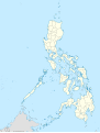 Blank SVG map of the Philippines
 -
 PNG map of provinces in the Philippines


Article(s): All articles with regards to the Philippines that needs a map
Request:
- Hi! Can someone update this file? The map needs to be subdivided into provinces, not regions. Kindly subdivide it without compromise to small islets in which that there are tendencies that they could be removed. Thank you! :-) -- adkranz (talk) 05:12, 21 July 2013 (UTC)
Graphist opinion(s):
Vulcanodon location map, southern Africa

Article(s): Vulcanodon
Request:
- Would it be possible to create a location map showing the site of discovery of Vulcanodon? Currently we are preparing this article for a GA nomination. The coordinates have been published (Raath, 1972): 16° 48' 30" S; 28° 16' 30" E. It is a small island in Lake Kariba, Zimbabwe. I've uploaded the location map from the publication (Cooper, 1984): [2]. I'm not sure which is better; an overview over entire Zimbabwe or only the lake. -- Jens Lallensack (talk) 07:45, 9 July 2013 (UTC)
Graphist opinion(s):
- Because nobody has answered yet I decided to play with
{{Location map}}, and a custom map overlay file using a NASA shot of the lake from Commons. Not sure if this will do, but the code for it is below - Begoon talk 12:09, 25 August 2013 (UTC)
{{Location map
| Zimbabwe
| relief = yes
| AlternativeMap = Vulcanodon location bg.png
| width = 320
| lat_deg = 16
| lat_min = 48
| lat_sec = 30
| lat_dir = S
| lon_deg = 28
| lon_min = 16
| lon_sec = 30
| lon_dir = E
| marksize = 10
| label_size = 100
| position = top
| label = '''Discovery{{nbsp}}site'''
| background = #F9F8E3
| caption = Location of [[Vulcanodon]] discovery site, [[Lake Kariba]], [[Zimbabwe]]
| overlay_image = Vulcanodon location bg.png
| link = Vulcanodon
}}
- Hi Begoon! Wow, thank you! The map looks great, I love it :) Thanks again, --Jens Lallensack (talk) 15:34, 25 August 2013 (UTC)
- You're welcome. I smiled, because the non-breaking space didn't show in the code box above (well, it showed as a space ), so you missed it in the copy paste you did to the article... I'll remember to use
{{]- Thanks, I'm not that familiar with these kind of templates ;) The map really is a great addition to the article now. --Jens Lallensack (talk) 17:23, 25 August 2013 (UTC)
- You're welcome. I smiled, because the non-breaking space didn't show in the code box above (well, it showed as a space
Arab League
-
 Arab-Israeli conflict
 -
 New base map done.


Article(s): Numerous articles relating to
Request:
- The map is outdated. The map shows South Sudan as part of Sudan, however South Sudan broke away from Sudan in 2011. Countries in light green are other members of the Arab League which have not been at war with Israel and according to the Arab League article, South Sudan is not part of it. So South Sudan needs to created on the map and shaded Gray. --Shadow (talk) 23:47, 14 April 2013 (UTC)
Graphist opinion(s):
- Request taken by Hytar (talk) 10:34, 21 August 2013 (UTC).: Please discuss herebefore I get it uploaded in a few days.
- Done. Whoever is free, please check and help me notify people watching/editing the pages that use the image. Thanks!Hytar (talk) 10:08, 25 August 2013 (UTC)