
Wittenberge
Wittenberge | |
|---|---|
 | |
 Flag  Coat of arms | |
Location of Wittenberge within Prignitz district 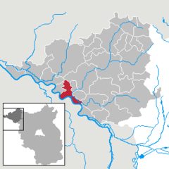 | |
Prignitz | |
| Subdivisions | 7 Stadtteile/Stadtbezirke |
| Government | |
| • Mayor (2016–24) | Oliver Hermann[1] (SPD) |
| Area | |
| • Total | 50.44 km2 (19.47 sq mi) |
| Elevation | 25 m (82 ft) |
| Population (2022-12-31)[2] | |
| • Total | 16,837 |
| • Density | 330/km2 (860/sq mi) |
| Time zone | UTC+01:00 (CET) |
| • Summer (DST) | UTC+02:00 (CEST) |
| Postal codes | 19322 |
| Dialling codes | 03877 |
| Vehicle registration | PR |
| Website | www.wittenberge.de |
Wittenberge (German: [ˌvɪtənˈbɛɐ̯ɡə] ⓘ) is a town of eighteen thousand people on the middle Elbe in the district of Prignitz, Brandenburg, Germany.
Geography
Wittenberge is situated at the right (north-eastern) bank of the middle
History
The site was marked out in 1239 at Wendischwalde and in 1300 the
From 15 August 1942 until 17 February 1945 a
Between the wars much architecture characteristic of the period was built in the form of workers' housing for the rapidly increased population. Only the railway workshops remain as significant employers of the old industries but the large, skilled workforce remains for the newer industries of precision engineering and applied chemistry.
Sights
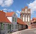
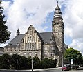
The oldest building in Wittenberge is Steintor (stone Gate) dating from 1450, an ancient gate of the medieval city wall.[5] Only a small part of Wittenberge's old town centre with half-timbered houses is left as many old houses were torn down before 1989. The railway station was built in a classicist style in 1846 and rebuilt after considerable bomb damage in World War II.[6] The Town Hall (Rathaus) with its tower measuring 51 metres was inaugurated in 1914.[7] It represents the style of Gründerzeit.
The Kultur- und Festspielhaus, a cultural centre, was built in 1959 in a typical style of Socialist realism. After the German reunification it was renovated in reinaugurated in 1999.[8] It is situated at Paul-Lincke-Platz, a place which is named after the composer Paul Lincke who lived in Wittenberge from 1881 to 1884.[9] In Bahnstraße, Wittenberge's main street, several residential buildings representing Stalinist architecture on a provincial level can be seen close to the Cultural Centre. They were renovated after the German reunification.
A factory for producing sewing-machines was founded in Wittenberge in 1903. Its clock tower measuring 49 metres which was built in 1928 is one of the symbols of Wittenberge.[10]
Demography
-
 Development of population since 1875 within the current Boundaries (Blue Line: Population; Dotted Line: Comparison to Population development in Brandenburg state; Grey Background: Time of Nazi Germany; Red Background: Time of communist East Germany)
 -
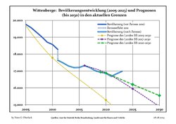 Recent Population Development and Projections (Population Development before Census 2011 (blue line); Recent Population Development according to the Census in Germany in 2011 (blue bordered line); Official projections for 2005-2030 (yellow line); for 2017-2030 (scarlet line); for 2020-2030 (green line)


|
|
|
-
 Railway Station
 -
 Steintor (Stone Gate)
 -
 Old town centre
 -
 Town Hall
 -
 Cultural Centre
 -
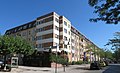 Socialist architecture in Bahnstraße after its renovation
 -
 Socialist architecture in Bahnstraße after its renovation
 -
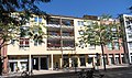 Wittenberge's main street: Bahnstraße
 -
 Railway bridge over the Elbe near Wittenberge


Mayor
- 1993–2008: Klaus Petry (SPD)
- since 2008: Oliver Hermann (independent)
Oliver Hermann was reelected in 2016 with 94,8% of the vote.
International relations
Twin towns – Sister cities
Wittenberge is
 Châlons-en-Champagne, France
 Elmshorn, Germany
 Razgrad, Bulgaria
Notable people
- Friedrich Burmeister (1888–1968), politician of the GDR (Minister of mail and telecommunications)
- Klaus Havenstein (1922–1998), German actor and cabaret artist
- Emanuel Hirsch (1888–1972), Protestant theologian
- Norbert Klaar (born 1954), sports shooter, Olympic champion 1976 (fast fire pistol)
- Richard Kruspe (born 1967), musician, guitarist of the band Rammstein
- Carl Lindenberg(1850–1928), jurist and philatelist
- Ulrich Makosch (1933–2008), journalist (television of the GDR)
- Uwe Potteck (born 1955), sportsman, Olympic champion 1976 (free pistol)
- Friedrich Schorlemmer (born 1944), theologian
- Herman C. Schultz (born 1860), politician
- Otto Telschow (1876–1945), politician of the NSDAP, Gauleiter, member of the Reichstag
- Stefanie Thurmann (born 1982), sports shooter
- Ulrich Woronowicz (1928–2011), Protestant pastor, theologian and social activist
References
- ^ Landkreis Prignitz Wahl der Bürgermeisterin / des Bürgermeisters, accessed 2 July 2021.
- Amt für Statistik Berlin-Brandenburg(in German). June 2023.
- ^ The camp is listed as No. 1587 Wittenberge, Kreis Wittenberge in the official German list of concentration camps Verzeichnis der Konzentrationslager und ihrer Außenkommandos Archived 23 April 2009 at the Wayback Machine (in German)
- ^ "So lief der Luftangriff auf Wittenberge | SVZ". 11 May 2022.
- ^ "Wittenberge - Steintor Wittenberge".
- ^ Stadt Wittenberge: Touristenführer 2022, p. 13. Wittenberge 2022
- ^ "Wittenberge - Rathaus Wittenberge".
- ^ Stadt Wittenberge: Wittenberger Stadtspaziergang, p. 12. Wittenberge 2022
- ^ Stadt Wittenberge: Wittenberger Stadtspaziergang, p. 19. Wittenberge 2022
- ^ Stadt Wittenberge: Wittenberger Stadtspaziergang, p. 21. Wittenberge 2022
- ^ Detailed data sources are to be found in the Wikimedia Commons.Population Projection Brandenburg at Wikimedia Commons
External links
![]() Media related to Wittenberge at Wikimedia Commons
Media related to Wittenberge at Wikimedia Commons
Towns and municipalities in Prignitz | ||
|---|---|---|
 | ||
| International | |
|---|---|
| National | |
| Geographic | |