
Xining
Xi'ning
西宁市 Sining | ||
|---|---|---|
License plate prefixes 青A | | |
| Website | www.xining.gov.cn (in Chinese) | |
| Xining | |||||
|---|---|---|---|---|---|
Mongolian Cyrillic Сэлэнг | | ||||
| Mongolian script | ᠰᠢᠨᠢᠩ | ||||
| |||||
Xi'ning.
The city was a commercial hub along the
The city is home to
History
Xi'ning has a history of over 2,100 years[5] and was a chief commercial hub on the Hexi Corridor caravan route to Tibet, handling especially timber, wool and salt in ancient times. The trade along the Hexi Corridor was part of a larger trade corridor along the Northern Silk Road, whose use was intensified in the 1st century BC after efforts by the Han dynasty to control this route.[6]
Under the Han dynasty (206 BC – 220 AD), a county called Linqiang was established to control the local Qiang tribesmen. It was again a frontier county under the Sui (581–618) and Tang (618–907) dynasties; during the 7th and early 8th centuries it was a center of constant warfare with Tuyuhun and Tibet. In 763, it was overrun by the Tibetans and while under Tibetan control was known to the Chinese as Qingtang cheng (青唐城). Recovered by the Song dynasty in 1104, it received the name Xi'ning (meaning "peace in the west") and has been the seat of a prefecture or superior prefecture under that name since that time. In the late 16th century, the Kumbum Monastery was founded some 19 km (12 mi) to the southeast, establishing Xi'ning as an important religious center for the Gelug School of Buddhists.
A major earthquake occurred May 22, 1927, measuring at a magnitude of 7.6. It was one of the deadliest earthquakes in China with a total count of over 40,000 deaths. It also caused large land fractures.
Xi'ning was the extraterritorial capital of the
Xi'ning was subjected to aerial bombardment by Japanese warplanes in 1941 during the Second Sino-Japanese War. The bombing spurred all ethnicities in Qinghai, including the local Qinghai Mongols and Qinghai Tibetans, against the Japanese.[9][10] The Salar Muslim General Han Youwen directed the defense of the city of Xi'ning during air raids by Japanese planes.[11][12]
Xi'ning was given municipal status in 1945.
Under the rule of Governor
Since the late 1950s, when the
Construction of a highway to the mineral-rich
Geography and climate
Xi'ning is located in the eastern part of Qinghai Province and lies on the Huangshui River. The four urban districts have a total area of 343 km2 (132 sq mi).
Xi'ning is located on the eastern edge of the
Xi'ning has also been dubbed the Summer Resort Capital of China owing to its cool summer, with a borderline
| Climate data for Xining (1991–2018 normals) | |||||||||||||
|---|---|---|---|---|---|---|---|---|---|---|---|---|---|
| Month | Jan | Feb | Mar | Apr | May | Jun | Jul | Aug | Sep | Oct | Nov | Dec | Year |
| Record high °C (°F) | 13.9 (57.0) |
20.8 (69.4) |
26.2 (79.2) |
31.8 (89.2) |
30.7 (87.3) |
31.9 (89.4) |
36.5 (97.7) |
34.0 (93.2) |
29.9 (85.8) |
25.2 (77.4) |
19.3 (66.7) |
13.3 (55.9) |
36.5 (97.7) |
| Mean daily maximum °C (°F) | 2.1 (35.8) |
5.8 (42.4) |
11.0 (51.8) |
16.6 (61.9) |
20.2 (68.4) |
23.2 (73.8) |
25.1 (77.2) |
24.2 (75.6) |
19.6 (67.3) |
14.5 (58.1) |
8.6 (47.5) |
3.4 (38.1) |
14.5 (58.2) |
| Daily mean °C (°F) | −7.9 (17.8) |
−3.6 (25.5) |
2.2 (36.0) |
8.3 (46.9) |
12.3 (54.1) |
15.6 (60.1) |
17.5 (63.5) |
16.6 (61.9) |
12.2 (54.0) |
6.2 (43.2) |
−0.7 (30.7) |
−6.3 (20.7) |
6.0 (42.9) |
| Mean daily minimum °C (°F) | −14.6 (5.7) |
−10.4 (13.3) |
−4.4 (24.1) |
1.4 (34.5) |
5.7 (42.3) |
9.2 (48.6) |
11.6 (52.9) |
11.1 (52.0) |
7.4 (45.3) |
0.9 (33.6) |
−6.5 (20.3) |
−12.6 (9.3) |
−0.1 (31.8) |
| Record low °C (°F) | −24.9 (−12.8) |
−20.7 (−5.3) |
−16.9 (1.6) |
−12.5 (9.5) |
−2.3 (27.9) |
0.2 (32.4) |
4.2 (39.6) |
3.7 (38.7) |
−1.1 (30.0) |
−12.5 (9.5) |
−19.0 (−2.2) |
−26.6 (−15.9) |
−26.6 (−15.9) |
| Average precipitation mm (inches) | 1.8 (0.07) |
1.9 (0.07) |
8.8 (0.35) |
20.7 (0.81) |
53.8 (2.12) |
64.5 (2.54) |
81.5 (3.21) |
87.0 (3.43) |
68.0 (2.68) |
23.3 (0.92) |
5.2 (0.20) |
1.2 (0.05) |
417.7 (16.45) |
| Average precipitation days (≥ 0.1 mm) | 3.2 | 2.9 | 4.9 | 7.1 | 11.7 | 14.4 | 15.4 | 14.5 | 14.4 | 7.7 | 3.2 | 2.1 | 101.5 |
| Average snowy days | 5.1 | 5.8 | 7.0 | 3.4 | 0.4 | 0 | 0 | 0 | 0.1 | 1.5 | 4.2 | 4.0 | 31.5 |
| Average relative humidity (%)
|
48 | 45 | 46 | 47 | 55 | 61 | 66 | 69 | 72 | 67 | 58 | 52 | 57 |
| Mean monthly sunshine hours | 196.7 | 200.3 | 223.9 | 232.8 | 240.5 | 230.1 | 223.8 | 215.8 | 181.4 | 200.0 | 201.8 | 192.6 | 2,539.7 |
| Percent possible sunshine | 63 | 65 | 60 | 59 | 55 | 53 | 51 | 52 | 49 | 58 | 67 | 64 | 58 |
| Source: China Meteorological Administration[17][18][19] | |||||||||||||
River management
In 2007, the
Air quality
According to a 2011 World Health Organization (based on Chinese statistics), Xi'ning has the second worst air quality (annual mean PM10 ug/m3 of 141) among eleven western China cities, and is worse than Beijing (121).[20]
Economy

The GDP per capita was 49,200 RMB (US$7,897) in 2015. Its main industries are wool spinning and textiles, fur, meat, milk, salt, and light processing industries.
Economic and Technological Development Zones
- Xi'ning Economic & Technological Development Zone
Xi'ning Economic & Technological Development Zone XETDZ) was approved as state-level development zone in July 2000. It has a planned area of 4.4 km2 (1.7 sq mi). XETDZ lies in the east of Xi'ning, 5 km (3.1 mi) away from downtown. The XETDZ is the first of its kind at the national level on the Qinghai-Tibet Plateau. It is established to fulfill the nation's strategy of developing the west.
XETDZ enjoys a convenient transportation system, connected by the Xi'ning–Lanzhou expressway and run through by two main roads, the broadest roads of the city. It is 4 km (2.5 mi) away from the railway station,[
It focuses on the development of following industries: chemicals based on salt lake resources, nonferrous metals, and petroleum and natural gas processing; special medicine, foods and bio-chemicals using local plateau animals and plants; new products involving ecological and environmental protection, high technology, new materials as well as information technology; and services such as logistics, banking, real estate, tourism, hotel, catering, agency and international trade.[21]
Demographics
Demographics
.jpg)
According to the 2020 Chinese census, the prefecture-level city of Xi'ning has a population of 2,467,965 inhabitants (2,208,708 as of the 2010 Chinese census), of whom 1,954,795 lived in the built-up (or metro) area made of 5 urban districts.
At present, four districts, three counties and a national economic and technological development zone are under the administration of the local government. With a population of more than two million, Xi'ning is the first city on the upper reaches of the Yellow River to achieve a population in the millions.
Ethnic diversity
There are about 37 nationalities living here, though only the Han, Hui, Monguor/Tu and Tibetans are numerically significant. Local traditions and customs are influenced by the Tibetans, Monguor, Muslims and Han. On 2010 Census numbers, Han Chinese represent 74.04 percent of the total population of Xi'ning, while Hui (16.26 percent), Tibetan (5.51 percent) and Tu (2.6 percent) are the main minority groups in the city.
Religion

Located in the southwest part of Xi'ning City, the
Having a history of over 600 years, the Dongguan Mosque, located in the Xi'ning City Zone, is one of the most famous mosques in the northwest region of China. It has splendid and diversiform towers, walls and halls in the mosque.
Another unique religious structure is the
There are more than 300 Christian meeting points in Xi'ning.[22]
The Catholic minority is pastorally served by the (pre-diocesan) Apostolic Prefecture of Xi'ning.
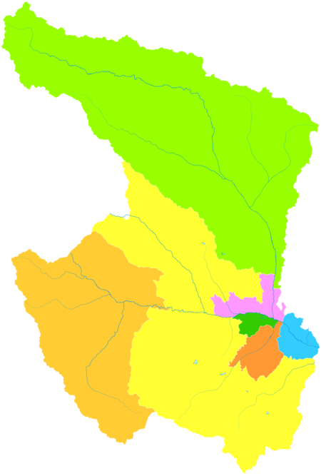
Administrative divisions
The municipality oversees seven
| Map | |||||||
|---|---|---|---|---|---|---|---|
| Name | Simplified Chinese | Hanyu Pinyin | Area (km2) | Population (2010) |
Density (/km2) | ||
| Urban | |||||||
Chengzhong District
|
城中区 | Chéngzhōng Qū | 11 | 296,987 | 26,999 | ||
Chengdong District
|
城东区 | Chéngdōng Qū | 115 | 359,688 | 3,128 | ||
Chengxi District
|
城西区 | Chéngxī Qū | 79 | 242,627 | 3,071 | ||
Chengbei District
|
城北区 | Chéngběi Qū | 138 | 299,002 | 2,167 | ||
| Suburban | |||||||
Huangzhong District
|
湟中区 | Huángzhōng Qū | 2,430 | 437,835 | 180 | ||
| Rural | |||||||
| Huangyuan County | 湟源县 | Huángyuán Xiàn | 1,609 | 136,632 | 85 | ||
| Datong Hui and Tu Autonomous County |
大通回族土族自治县 | Dàtōng Huízú Tǔzú Zìzhìxiàn | 3,090 | 435,937 | 139 | ||
Education
Colleges and universities
Private schools
Xi'ning International Academy is an English-language international school.
Transportation
.jpg)

Xi'ning is situated in a fertile mountain basin in the valley of the Huangshui (river), a tributary of the Yellow River, that acts as a river port. The city lies about 200 km (120 mi) west of Lanzhou, the capital of Gansu province, on what was traditionally the main trade route from northern China into Tibet and the Qaidam Basin. These routes are now followed by modern highways.
Railway

Since 1959
The second major railway serving Xi'ning is the
Unlike many other Chinese cities, where the conventional and high-speed trains stop at different train stations, Xi'ning railway station is served by both types of trains. Thus it can be used as a transfer point for e.g. a passenger traveling from Xinjiang to Tibet.
Air
Xi'ning Caojiapu International Airport serves the area with regularly scheduled passenger flights to major Chinese cities including Beijing, Shanghai, Hong Kong, Chengdu, Kunming, Xi'an, and Wuhan.
Highway
- China National Highway 214
- China National Highway 227
- China National Highway 315
- G6 Beijing–Lhasa Expressway
Food

Xi'ning's cuisine is distinct from other Chinese cities and mainly uses food products native to the area.
Local specialties include: Feng'er Liji (a round lamb tenderloin), Danbai Chongcao Ji (a medicine cuisine made of chicken, Chinese
There are also many small restaurants offering noodles. Gan Ban is a very common noodle dish. Perhaps Mian Pian, which means "noodle leaves" is the most common noodle plate among the Qinghai people. On the streets, many Muslims sell spicy lamb brochettes. Due to the cold climate, residents of Xi'ning are also fond of strong spirits; Xi'ning has the reputation of being one of the regions of heaviest alcohol consumption in China.[citation needed]
Notes
- ^ /ʃiːˈnɪŋ/, shee-NING;[3] [ɕí.nǐŋ]; alternatively known as Si'ning
References
- ^ "China: Qīnghăi (Prefectures, Cities, Districts and Counties) - Population Statistics, Charts and Map".
- ISBN 978-7-5037-7834-6. Archived from the originalon 2017-12-28. Retrieved 2017-06-05.
- ^ "Xining". Lexico UK English Dictionary. Oxford University Press. Archived from the original on April 17, 2021.
- ^ "Illuminating China's Provinces, Municipalities and Autonomous Regions". PRC Central Government Official Website. Retrieved 2014-05-17.
- ^ [1] Archived September 29, 2007, at the Wayback Machine
- ^ "Silk Road, North China [Northern Silk Road, North Silk Road] Ancient Trackway : The Megalithic Portal and Megalith Map". Megalithic.co.uk. Retrieved 2014-02-07.
- ISBN 0-674-11968-1. Retrieved 2010-06-28.)(Original from the University of Michigan)
{{cite book}}: CS1 maint: multiple names: authors list (link - ISBN 0-674-01240-2. Retrieved 2010-06-28.
- ^ 回顾1941年日机轰炸西宁:改变青海历史轨迹 - 抗战故事 - 抗日战争纪念网.
- ^ "1941:日军飞机轰炸西宁--党史频道-人民网".
- ^ "怀念我的父亲──韩有文". Archived from the original on March 22, 2012. Retrieved April 3, 2011.
- ^ http://www.kunlunpai.cn/thread-1211-1-1.html[permanent dead link]
- ^ "CITY IN WEST CHINA TO GET PIPED WATER; American 'Sells' Warlord at Sining on System to Aid Health --People Suspect Clear Fluid". THE NEW YORK TIMES. 3 February 1947. Retrieved 2010-11-28.
- ^ HENRY R. LIEBERMAN (15 September 1948). "ENLIGHTENED RULE BOLSTERS TSINGHAI; General Ma, War Lord, Enjoys Passion for Education -- He Taxes as Need Arises". The New York Times. Retrieved 2010-11-28.
- S2CID 143975998.
- ^ 中国气象科学数据共享服务网. China Meteorological Administration. Archived from the original on March 2, 2015. Retrieved February 22, 2014.
- ^ 中国气象数据网 - WeatherBk Data (in Chinese (China)). China Meteorological Administration. Retrieved 2020-04-15.
- ^ 中国地面国际交换站气候标准值月值数据集(1971-2000年). China Meteorological Administration. Archived from the original on 2013-09-21. Retrieved 2010-05-25.
- ^ CMA台站气候标准值(1991-2020) (in Chinese). China Meteorological Administration. Retrieved 2023-04-11.
- ^ WHO report OAP_database_8_2011.xls
- ^ "Xining Economic & Technology Development Zone | China Industrial Space". Rightsite.asia. 2013-11-18. Retrieved 2014-02-07.
- ^ "Discovering China: CityScape". Library.thinkquest.org. Archived from the original on 2013-05-08. Retrieved 2014-02-07.