
Y Lliwedd
| Y Lliwedd | |
|---|---|
Nuttall | |
| Coordinates | 53°03′36″N 4°03′25″W / 53.06°N 4.0569°W |
| Naming | |
| English translation | colourless peak |
| Language of name | Welsh |
| Pronunciation | Welsh: [ə ˈɬɪwɛð] |
| Geography | |
| Location | Gwynedd, Wales |
| Parent range | Snowdonia |
| OS grid | SH622533 |
| Topo map | OS Landranger 115 |
| Name | Grid ref | Height | Status |
|---|---|---|---|
| Y Lliwedd East Peak | 893 m (2,930 ft) | Nuttall
| |
| Lliwedd Bach | 818 m (2,684 ft) | Nuttall
| |
| Gallt y Wenallt | 619 m (2,031 ft) | Nuttall
|
Y Lliwedd is a
Snowdonia National Park, North Wales
.
Its summit lies 898 metres (2,946 ft)
above sea level
.
The eastern flanks are steep cliffs rising above Glaslyn and Llyn Llydaw. Y Lliwedd is the most conspicuous of the peaks for those who approach Snowdon via the Miners' and Pyg tracks. Few that summit Snowdon continue over to Y Lliwedd as the challenge of Wales' highest peak is enough, leaving Y Lliwedd quiet and peaceful even when queues are forming at the summit of Snowdon.
Snowdon Horseshoe. The noted British climber George Mallory undertook many of his early climbs here. It was also the site of considerable training activity for the 1953 British Everest Expedition
.
The north face of Y Lliwedd was explored in the late 19th century and in 1909 was the subject of the first British climbing guide, The Climbs on Lliwedd by
J. M. A. Thomson and A. W. Andrews
.
Two subsidiary peaks of Y Lliwedd are listed as
Nuttalls: Lliwedd Bach 818 metres (2,684 ft): SH628532 and Y Lliwedd East Peak 893 metres (2,930 ft): SH623532.[1]
References
- ISBN 1-85284-304-7.
Gallery
-
 Y Lliwedd on the left, Snowdon on the right
 -
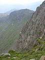 Typical steep grassy and loose section of cliff
 -
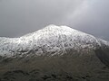 Y Lliwedd in snow from the flank of Yr Aran


