
Yellowstone Falls
| Upper Falls of the Yellowstone River | |
|---|---|
.jpg) | |
 | |
| Location | Yellowstone National Park, Park County, Wyoming, United States |
| Coordinates | 44°42′46″N 110°29′59″W / 44.71278°N 110.49972°W |
| Total height | 109 feet (33 m) |
| Watercourse | Yellowstone River |
| Lower Falls of the Yellowstone River | |
|---|---|
 | |
| |
| Location | Yellowstone National Park |
| Coordinates | 44°43′05″N 110°29′46″W / 44.71806°N 110.49611°W |
| Total height | 308 feet (94 m) |
| Watercourse | Yellowstone River |
Yellowstone Falls consist of two major waterfalls on the Yellowstone River, within Yellowstone National Park, Wyoming, United States. As the Yellowstone river flows north from Yellowstone Lake, it leaves the Hayden Valley and plunges first over Upper Falls of the Yellowstone River and then a quarter mile (400 m) downstream over Lower Falls of the Yellowstone River, at which point it then enters the Grand Canyon of the Yellowstone, which is up to 1,000 feet (304 m) deep.
Upper Falls
The Upper Falls of the Yellowstone River (44°42′46″N 110°29′59″W / 44.71278°N 110.49972°W) are 109 feet (33 m) high. The brink of Upper Falls marks the junction between a hard rhyolite lava flow and weaker glassy lava that has been more heavily eroded.
Lower Falls
Cascading from the 590,000 year old Canyon Rhyolite lava flow, Lower Falls of the Yellowstone River is the largest volume waterfall in the Rocky Mountains of the United States.[citation needed] These falls (44°43′05″N 110°29′46″W / 44.71806°N 110.49611°W) are 308 feet (94 m) high, or nearly twice as high as Niagara Falls. The volume of water flowing over Lower Falls can vary from 680 cu ft/s (19 m3/s) in the autumn, to 8,400 cu ft/s (240 m3/s) at peak runoff in late springtime.[citation needed] The flow rate of Lower Falls is much less than that of Niagara Falls, as the Yellowstone River is only 70 feet (21 m) wide at the point at the brink, whereas the Niagara River is 2,600 feet (790 m) in width as it approaches the crest line of Horseshoe Falls.
History
It is likely that
Over the years the estimates of the height of Lower Falls has varied dramatically. In 1851 Jim Bridger estimated its height at 250 feet. One outrageous newspaper story from 1867 placed its height at "thousands of feet". A map from 1869 gives the falls its current name of Lower Falls for the first time and estimates the height at 350 feet. However the current map lists Lower Falls at a height of 308 feet.
Viewing the falls
Today, there are numerous vantage points for viewing the falls. The Canyon loop road skirts north rim of the canyon with several vehicle parking areas. One trail leads down to the Brink of Lower Falls, a steep third of a mile (600 m). Uncle Tom's Trail descends from the east down a series of stairs attached to the cliffs.[3] As of 2022 it was closed.
The Lower Falls area is located just to the south and east of Canyon Village in Yellowstone National Park. A one-way loop drive starting south from Canyon Junction takes one to the brink of the Grand Canyon of the Yellowstone and offers four viewpoints, with the first stop at the trail that leads to the top of the Lower Falls. The one-way drive continues east and north past the other viewpoints, rejoining the main Grand Loop road from the east at Canyon Junction once more.
Image gallery
-
Video of Yellowstone Lower Falls, 2019
-
 Upper Falls and downstream view
 -
 Brink of Upper Falls, 1916
 -
 Upper Falls by Private Moore, 1870
 -
 Lower Falls in Grand Canyon of Yellow Stone from Artist Point
 -
 Lower Falls by Private Moore, 1870
 -
 Lower Falls by Thomas Moran, 1871
 -
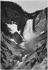 Lower Falls by Ansel Adams, 1941
 -
Video of the brink of the Lower Falls, 2010
-
 Brink of the Lower Falls, 2021


See also
Notes
- ISBN 156579351X.
- ^ Langford, Nathaniel Pitt (1905). The Discovery of Yellowstone Park; Diary of the Washburn Expedition to the Yellowstone and Firehole Rivers in the Year 1870. St. Paul, MN: Frank Jay Haynes.
- ^ "South Rim". Yellowstone. National Park Service. Retrieved 26 March 2017.
- "Yellowstone Waterfalls". Archived from the original on 2004-06-11. Retrieved 2006-07-08.
- "Yellowstone National Park - The Canyon Through Time". Archived from the original on 2010-05-02. Retrieved 2007-07-13.
External links
 Media related to Yellowstone Falls at Wikimedia Commons
- Video of Lower Falls (1899) - Thomas Edison, Library of Congress
Yellowstone National Park - Tower-Roosevelt and Lamar Valley | ||
|---|---|---|
Geography, historic structures and other attractions in the Tower Roosevelt and Lamar Valley areas | ||
| Structures and history |  | |
| Geography and geology |
| |
| ||
Cheyenne (capital) | |
| Topics | |
| Society |
|
| Regions | |
| Cities | |
| Counties | |