
Acaster Selby
| Acaster Selby | |
|---|---|
North Yorkshire | |
| Ambulance | Yorkshire |
| UK Parliament | |
Acaster Selby is a village in the former
History
The name is derived from the Latin word for a camp, 'castra', indicating that the Roman army may once have been based near here. There is no longer any signs of such an encampment which was thought to have provided protection of the waterway to Tadcaster. The use of Selby indicates that the lands were brought within the control of Selby Abbey. This was done by Osbert de Arches at the time of the Norman Conquest and confirmed in the reign of Richard I.[1]
The village is listed in the
College Farm at Acaster Selby is named after a former college, or a
Geography
The village has an area of 1,523 acres (6.2 km2).[1] It lies 1.3 miles (2.1 km) south-east of Appleton Roebuck.
Demography
According to the 1881 census the population was 115.[1] The 2001 census showed a population of 56 in 20 households.[4]
Governance
The Parish is part of joint parish with Appleton Roebuck and has one seat on its council.[5] It is part of the Selby & Ainsty constituency. It is part of the Appleton Roebuck and Church Fenton electoral division of North Yorkshire Council.[6]
Religion
See also
Gallery
-
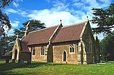 St John The Evangelist Church, Acaster Selby
 -
 River Ouse, Acaster Selby


References
- ^ ISBN 1-86150-299-0.
- ^ "Domesday Record". Archived from the original on 26 May 2013. Retrieved 13 October 2012.
- ^ Historic England. "St Andrew's College and moat, 440m north east of College Farm (1017457)". National Heritage List for England. Retrieved 25 January 2018.
- ^ "Census 2001". Archived from the original on 28 September 2011. Retrieved 13 October 2012.
- ^ "Parish Council". Archived from the original on 14 June 2011. Retrieved 13 October 2012.
- ^ "Divisions North Yorkshire Council". hub.arcgis.com. Retrieved 14 October 2023.
- ^ Historic England. "Church of St John (1316323)". National Heritage List for England. Retrieved 25 January 2018.
External links
 Media related to Acaster Selby at Wikimedia Commons
- Acaster [Selby] in the Domesday Book
| Authority control databases: National |
|---|