
Adullam-France Park
| Adullam-France National Park | |
|---|---|
| פארק עדולם-צרפת | |
 Lookout point at Hurvat Burgin | |
| Nearest city | Beit Shemesh |
| Coordinates | 31°39′08″N 34°57′22″E / 31.6522848°N 34.95609°E |
| Established | 2008 |
| www | |
Adullam-France Park (
Palestinian Arab
control – which marks its limit.
Park features

The park's main attraction is its pristine, unspoiled beauty; gently rolling limestone hills clad in natural Mediterranean vegetation of underbrush (viniculture.
Etymology
The park takes its name from the biblical Adullam, now a ruin, but where King David once found refuge when he fled from Saul.

Main archaeological sites

- Ḥurvat Burgin (31°38′12″N 34°58′11″E / 31.636667°N 34.969722°E), a site maintained by the JNF (KKL) in Israel, and where extensive archaeological excavations have been conducted. The site features ancient burial tombs, and a labyrinth of underground hiding places believed to have been associated with the Bar Kokhba era, a Roman villa, columbarium (dovecote), among other things. Until 1948, the Palestinian Arab village Khirbat Umm Burj was here.[5]
- Horvat 'Ethri (31°38′58″N 34°58′19″E / 31.649472°N 34.972007°E), a partially restored town dating back to the Second Temple period, with a public building believed to be a synagogue, ritual baths, wine presses and caves.
- Ḥurvat Midras (Madras) (31°39′24″N 34°56′12″E / 31.656545°N 34.936648°E), an archaeological site 32 kilometres (20 mi) south of Jerusalem and dating back to the Bar-Kokhba era, replete with no less than 56 caves and cisterns. The site also abounds with over twenty underground passages, one of which connecting three older cisterns with 50 meters of tunnels, and another connected by 90 meters of tunnels,[6] an ancient burial site with sarcophagus, and a large columbarium. A survey of the site was conducted in 2010 by Amir Ganor and Alon Klein, on behalf of the Israel Antiquities Authority (IAA).[7] The site is located within the Adullam Grove Nature Reserve.
The main entrance to the park is accessible from regional hwy. 38, some 200 metres (660 ft) north of
Elah Valley, Britannia Park and the Luzit
Caves.
In 2010, a survey of the Adullam-France Park was conducted by Noygborn Hagit on behalf of Israel Antiquities Authority (IAA).[8]
See also
Gallery
-
 Child rappelling in an underground vault with columbarium (dovecote) at Park
 -
 Entrance to large cave in the Adullam-France Park
 -
 Cave of the columns, Hurvat Burgin
 -
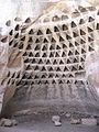 A columbarium in the Midras ruins
 -
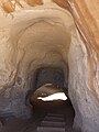
 Entrance to a tomb at the Midras ruins
 -
 View of Itri ruins
 -
 Exploring a tunnel in the Midras Ruin
 -
 Columbarium at the Midras Ruin
 -
 General landscape of the Adullam-France Park
 -
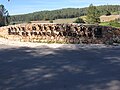
 Ruins at the site of Khirbet Midras
 -
 The entrance to the Adullam-France Park
 -
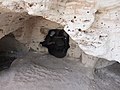
 Niche in columbarium, at the Midras ruin


.jpg)
.jpg)


References
- ^ "Lachish (BiblePlaces.com)". BiblePlaces.com. Retrieved 2023-08-01.
- Kitchener's PEF Survey of Palestine Map (Map # 21), the site is listed as Umm Burj, a place that had already been a ruin in Conder's time (p. 380), but apparently resettled around the 20th century, and continuing to be until 1948.
- ^ This ruin appears in Conder's and Kitchener's 1878 Survey of Palestine map (Sheet XXI) under the name Khurbet Rubba, and lies on a hilltop to the north of Hurvat Itri (Umm Suweid).
- ^ Bakitzur – Mateh Yehuda Regional Council Weekly, Issue 388 (23 February 2017), p. 24 (Hebrew)
- ^ Amir Ganor and Alon Klein (2011). "Horbat Burqin, Preliminary Report". Hadashot Arkheologiyot. 123.
- ^ Mark Alan Chancey & Adam Lowry Porter, "The Archaeology of Roman Palestine", in: Near Eastern Archaeology, vol. 64, no. 4 (Dec., 2001), p. 188
- ^ Israel Antiquities Authority, Excavators and Excavations Permit for Year 2010, Survey Permit # A-5963
- ^ Israel Antiquities Authority, Excavators and Excavations Permit for Year 2010, Survey Permit # A-5821
External links
- Nature and Parks Authority Official Site
- Adullam Park Map
- The Jewish National Fund (KKL), Adullam-France Park: A Green Event Amid the Splendor of Nature