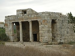
Mazor Mausoleum
 | |
 | |
| 32°02′47″N 34°56′46″E / 32.0465°N 34.9461°E | |
| Location | |
|---|---|
| Type | Mausoleum |
| Completion date | 3rd century AD |
The Mazor Mausoleum (
sarcophagi
in the mausoleum.
History
In the
1948
.
In July 1949, Israel decided to raze the mausoleum, after the Israeli Ground Forces had used the building for target practice. However, an antiquities inspector managed to stop the destruction.[3]
Nowadays
The Mazor mausoleum has been declared a "national park" and is currently under the management of
Israel's National Parks Authority.[4]
References
Wikimedia Commons has media related to Mazor Mausoleum.
- ^ Conder and Kitchener, 1882, SWP II, pp. 365-367
- ^ "The Mazor Mausoleum". Ministry of Tourism. Retrieved 2009-01-13.
- ^ History Erased, by Meron Rapoport, Haaretz, 05.07.07
- ^ "גן לאומי מאוזוליאום מזור – iNature". inature.info.
