
Bayt 'Itab
Bayt 'Itab
بيت عطاب Beit 'Atab, Bait 'Itab | ||
|---|---|---|
 Bayt 'Itab | ||
| Etymology: ""House of Atab"[1] | ||
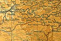
.jpg) 1870s map 1870s map .jpg) 1940s map 1940s map.jpg) modern map modern map .jpg) 1940s with modern overlay map 1940s with modern overlay mapA series of historical maps of the area around Bayt 'Itab (click the buttons) | ||
Geopolitical entity Mandatory Palestine | | |
| Subdistrict | Jerusalem | |
| Date of depopulation | 21 October 1948[4] | |
| Area | ||
| • Total | 5,447 dunams (5.447 km2 or 2.103 sq mi) | |
| Population (1945) | ||
| • Total | 540[2][3] | |
| Cause(s) of depopulation | Military assault by Yishuv forces | |
| Current Localities | Nes Harim[5] | |
Bayt ʿIṭāb (
After a military assault on Bayt ʿIṭāb by Israeli forces in October 1948, the village was depopulated and demolished.[6] Many of the villagers had fled to refugee camps in the West Bank less than 20 kilometres (12 mi) from the village. In 1950, an Israeli moshav, Nes Harim, was established north of the built up portion of Bayt 'Itab, on an adjacent peak.[7]
History
Late Roman Enadab
Bayt ʿIṭāb is identified with Enadab, a name that appears in Eusebius' Onomasticon, written in the fourth century CE.[8][9] Agmon conjectured that its ancient name was batˁaṭami = "place of the vulture-goddess shrine", in reference to the Egyptian deity Nekhbet.[10]
Crusader period

In the mid-12th century, Bayt ʿIṭāb hosted an impressive maison forte (see French article here), or fortified hall house, in the ancient centre of the modern village, that is thought to have served as the residence of Johannes Gothman, a Frankish crusader knight. The building had two stories, both vaulted; the ground floor entrance was protected by a slit-machicolation and had stairs leading to the basement and upper floor.[11]
Gothman's wife was forced to sell his landholdings after he was taken prisoner by Islamic forces in 1161, in order to raise the money needed for his ransom.[6][12][13][14][15] The village was then acquired by and made a fief of the Church of the Holy Sepulchre, possibly organised by the Order of the Holy Sepulchre.[16]
The Arabic name of the village appears in Latin transliteration as Bethaatap in a list recording the 1161 sale of Gothman's land.[6][13] Its affiliations with the Crusader era has led some to erroneously characterize the village as "Crusader", when in fact its habitation by Arabs predates, persisted through and extended beyond this period.[6]
Ottoman period
Edward Robinson visited the village in 1838, and described its stone houses, several of which had two storeys, as solidly built. In the center of the village were the ruins of a castle or tower. Robinson estimates, the village population was six to seven hundred people. He notes that Beit 'Atab, as he transcribes it, was the chief town of the 'Arkub (Arqub) district and the Nazir (warden) of the district lived there. Robinson recounts that he was "a good-looking man" from the Lahaam clan, and that when they arrived in the village, he was sitting conversing with other sheikhs on a carpet under a fig tree. Rising to greet them, he invited them to stay for the night, but as they were in a hurry to see more of the country before the setting of the sun, and so declined his offer.[17]
In the mid-19th century, the sheikh of Bayt 'Itab was named 'Utham al-Lahham (Sheikh 'Othman al-Lahaam). He had been exiled in 1846, but had managed to escape and return. A supporter of the Qays faction, Lahham was in conflict with the
In February 1855, the Abu Ghosh clan came to the aid of Atallah, conquered Bayt ʿIṭāb, and imprisoned ʿUtham al-Laḥḥām in his own house. With the help of one of the younger members of the Abu Ghosh clan,
When French explorer
An official Ottoman village list from about 1870 cited by Socin shows that Bayt 'Itab had a total of 89 houses inhabited by 241 people, with the caveat that the population count included men only.[24]
In the late 19th century, Bayt ʿIṭāb was described as a village built on stone, perched on a rocky knoll that rose 60 to 100 feet above the surrounding hilly ridge. Its population in 1875 was approximately 700, all
According to Hartmann, in 1883 Bayt 'Itab had 100 houses.[26] In 1896 the population of Bet 'atab was estimated to be about 543 persons.[27]
British Mandatory period
In the
The original layout of Bayt ʿIṭāb was circular, but newer construction to the southwest (towards Sufla), gave the village an arc-shape. Most houses were built of stone.[5] Agriculture was the main source of income. The village owned extensive areas on the coastal plain that were planted with grain. During the British Mandate in Palestine, some of this land was expropriated to make a large, government-owned woodland.[5]
In the
-
 Bayt 'Itab, Mandate survey, 1:20,000
 -
 Bayt 'Itab, 1945, 1:20,000


1948 War; Israeli period
War, depopulation and destruction


The village was depopulated between 19 and 24 October 1948, after the
In 1950, the Israeli moshav-type village of Nes Harim was established north of the village site on village land.[5] In 1992, Palestinian historian Walid Khalidi found the site strewn with rubble and the remains of a Crusader fortress. He noted two cemeteries that lay east and west of the village, and the fact that some of the surrounding land was cultivated by Israeli farmers.[5]
Archaeological park
[36] Remains at the site include a Crusader fortress, vaults, remnants of a wall and towers, tunnels, a columbarium and an olive press. A conservation project was undertaken to stabilize the vaulted building utilizing traditional technology.[37]
Geography
Bayt ʿIṭāb was located 17.5 kilometres (10.9 mi) south southwest of Jerusalem, on a high mountain 665 metres (2,182 ft) above sea level, overlooking some lower mountains peaks below.[8][36] A Roman road ran along a narrow ridge to the south of the village which also passed by Solomon's Pools.[38] A low cliff to the east of the village was known as 'Arâk el-Jemâl ("the cliff, cavern or buttress of the camels").[39]
Southeast of the village on the main road was the chief village spring known as ʿAin Beit ʿAṭāb (
Biblical identification
In 1879, Lieutenant C. R. Conder, of the Palestine Exploration Fund (PEF), thought that the place Bayt ʿIṭāb should be identified with the biblical site known as "Rock of Etam" (Judges 15:11), by way of a corruption of its name, and which, according to Conder, was not a town at all, but "a strong rock."[45][46] John William McGarvey (1881) quotes Conder on the linguistic evidence: "The substitution of B for M is so common (as in Tibneh for Timnah) that the name Atab may very properly represent the Hebrew Etam (eagle's nest); and there are other indications as to the identity of the site."[47]
Survey of Western Palestine (1883), notes that the name of the "curious cave" at Bayt ʿIṭāb in Arabic is Bir el-Has Utah. Unable to find a meaning for the word in Arabic, they find it corresponds to the Hebrew word Hasutah, "[...] which is translated 'a place of refuge.' Thus the name seems to indicate that this place has been used from a very early time as a lurking or hiding place, as we gather it to have been in the time of Samson."
Henry B. Tristram (1897) writes of Bayt 'Itab that it crowned "a remarkable rocky knoll," which he states is, "probably, the Rock Etam." Noting that an ancient tunnel ran down from the village eastward through the rock to the chief spring, he speculates that this would have made a good hiding place for Samson when according to biblical tradition, he "went down and dwelt in the top of the rock Etam" (Book of Judges, xv. 8).[48]
See also
- Depopulated Palestinian locations in Israel
- List of villages depopulated during the Arab-Israeli conflict
References
- ^ Palmer, 1881, p. 186
- ^ a b Department of Statistics, 1945, p. 24
- ^ a b c Government of Palestine, Department of Statistics. Village Statistics, April, 1945. Quoted in Hadawi, 1970, p. 56
- ^ Morris, 2004, p. xx, village #343. Also gives cause of depopulation
- ^ a b c d e f g Khalidi, 1992, p. 275
- ^ a b c d e f Benvenisti, 2002, in a chapter named "The Convenience of the Crusades", p. 301
- ^ "ERETZ Magazine". www.eretz.com.
- ^ a b Khalidi, 1992, p. 274
- ^ Eusebius, Onomasticon - The Place Names of Divine Scripture, (ed.) R. Steve Notley & Ze'ev Safrai, Brill: Leiden 2005, p. 92 (§477)
- .
- ^ CHRAM, 1994, p. 342 pg=PA342 short
- ^ de Roziére, 1849, pp. 195-199, No. 99-100; cited in Röhricht, 1893, RRH, p. 97, No 368-9
- ^ a b Levy, 1998, p. 505
- ^ Riley-Smith, 2001, p. 171
- ^ Pringle, 1997, p.26
- ^ a b c d e Conder and Kitchener, 1883, SWP III, p. 23
- ^ Robinson and Smith, 1841, vol 2, p. 338. Cited in Khalidi, 1992, p. 274
- ^ Schölch, 1993, p. 231
- ^ Schölch, 1993, p. 229
- ^ a b Schölch, 1993, p. 232
- ^ Benvenisti notes that, "The long history of Beit ʿIṭāb and the tale of the wars of the Quays and Yaman have been recounted at length in many books, and British consul James Finn (mid-nineteenth century) left a particularly vivid description of this village and its houses, both ancient and new. But there is no mention of any of this in Israeli guidebooks, save for the routine remark, "destroyed in the War for Independence." By contrast, the guidebook makes sure to inform its readers that "it is almost certain that its Arab name, Beit ʿIṭāb, is a corruption of its Latin name, Atap, meaning a small fortress," and at the site there are "remains of ancient structures, apparently from a Crusader farm.""
- ^ Schölch, 1993, pp.232-3, party based on Finn, p.193 ff.
- ^ Guérin, 1869, pp. 381-3, as cited in Conder and Kitchener, 1883, SWP III, p. 83
- ^ Socin, 1879, p. 145
- ^ Conder and Kitchener, 1883, SWP III, pp. 22-24. Also quoted in Khalidi, 1992, p. 275
- ^ Hartmann, 1883, p. 145
- ^ Schick, 1896, p. 123
- ^ Barron, 1923, Table VII, Sub-district of Ramleh, p. 21
- ^ a b Mills, 1932, p. 19
- ^ Kark and Oren-Nordheim, 2001, p. 192
- ^ Government of Palestine, Department of Statistics. Village Statistics, April, 1945. Quoted in Hadawi, 1970, p. 101
- ^ Government of Palestine, Department of Statistics. Village Statistics, April, 1945. Quoted in Hadawi, 1970, p. 151
- ^ a b Morris, 2004, p. 466
- ^ Har’el: Palmach brigade in Jerusalem, Zvi Dror (ed. Nathan Shoḥam), Hakibbutz Hameuchad Publishers: Benei Barak 2005, p. 270 (Hebrew)
- ^ Rosenfeld, 2004, p. 322
- ^ a b "Conservation Department: Heritage Conservation in Israel - Projects: Beit Itab". Israel Antiquities Authority. Retrieved 2009-09-26.
- ^ "Projects - Preservation". www.iaa-conservation.org.il.
- ^ Conder and Kitchener, 1883, SWP III, p. 38
- ^ Palmer, 1881, p. 284
- ^ Palmer, 1881, p. 278
- ^ Palmer, 1881, p. 279
- ^ Palmer, 1881, p. 280
- ^ Lias, 2009, pp. 165-166
- ^ Conder and Kitchener, 1883, SWP III, p. 137
- ^ Conder, 1879, pp. 273, 275
- ^ Conder, 1878, p. 117
- ^ a b McGarvey, 2002, pp. 246-247
- ^ Tristram, 1897, pp. 66-67
Bibliography
- Barron, J. B., ed. (1923). Palestine: Report and General Abstracts of the Census of 1922. Government of Palestine.
- ISBN 978-0-520-23422-2.
- CRAHM (1994). Château Gaillard études de castellologie médiévale, XVI: actes du colloque international tenu à Luxembourg, 23-29 août, 1992. Publications du CRAHM. ISBN 978-2-902685-03-5.
- Conder, C.R. (1879). Tent Work in Palestine - A Record of Discovery and Adventure. Vol. 1. London: Richard Bentley & Son.
- Conder, C.R. (1878). "The Rock Etam". Quarterly Statement - Palestine Exploration Fund. 10: 116–118.
- Conder, C.R.; Kitchener, H. H. (1883). The Survey of Western Palestine: Memoirs of the Topography, Orography, Hydrography, and Archaeology. Vol. 3. London: Committee of the Palestine Exploration Fund.
- Department of Statistics (1945). Village Statistics, April, 1945. Government of Palestine.
- Finn, J. (1878). E.A.Finn (ed.). Stirring Times, or, Records from Jerusalem Consular Chronicles of 1853 to 1856. Edited and Compiled by His Widow E. A. Finn. With a Preface by the Viscountess Strangford. Vol. 1. London: C.K. Paul & co. (Unhman al-Latham description: p230)
- Finn, J. (1878). E. A. Finn (ed.). Stirring Times, or, Records from Jerusalem Consular Chronicles of 1853 to 1856. Edited and Compiled by His Widow E. A. Finn. With a Preface by the Viscountess Strangford. Vol. 2. London: C.K. Paul & co.(Bayt 'Itab: p.193 ff.)
- Guérin, V. (1869). Description Géographique Historique et Archéologique de la Palestine (in French). Vol. 1: Judee, pt. 2. Paris: L'Imprimerie Nationale.
- Hadawi, S. (1970). Village Statistics of 1945: A Classification of Land and Area ownership in Palestine. Palestine Liberation Organization Research Centre.
- Hartmann, M. (1883). "Die Ortschaftenliste des Liwa Jerusalem in dem türkischen Staatskalender für Syrien auf das Jahr 1288 der Flucht (1871)". Zeitschrift des Deutschen Palästina-Vereins. 6: 102–149.
- ISBN 978-0-8143-2909-2.
- ISBN 0-88728-224-5.
- Levy, Thomas (1998). The archaeology of society in the Holy Land (2nd illustrated ed.). Continuum International Publishing Group. ISBN 978-0-8264-6996-0.
- Lias (2009). The Book of Judges. BiblioBazaar, LLC. ISBN 978-1-110-82900-2.
- ISBN 978-1-4021-9277-7.
- Mills, E., ed. (1932). Census of Palestine 1931. Population of Villages, Towns and Administrative Areas. Jerusalem: Government of Palestine.
- ISBN 978-0-521-00967-6.
- Palmer, E. H. (1881). The Survey of Western Palestine: Arabic and English Name Lists Collected During the Survey by Lieutenants Conder and Kitchener, R. E. Transliterated and Explained by E.H. Palmer. Committee of the Palestine Exploration Fund.
- ISBN 0521-46010-7.
- ISBN 978-0-19-285428-5.
- Robinson, E.; Smith, E. (1841). Biblical Researches in Palestine, Mount Sinai and Arabia Petraea: A Journal of Travels in the year 1838. Vol. 2. Boston: Crocker & Brewster. ( pp. 326, 338-340)
- Rosenfeld, Maya (2004). Confronting the occupation: work, education, and political activism of Palestinian families in a refugee camp (Illustrated ed.). Stanford University Press. ISBN 978-0-8047-4987-9.
- Röhricht, R. (1893). (RRH) Regesta regni Hierosolymitani (MXCVII-MCCXCI) (in Latin). Berlin: Libraria Academica Wageriana.
- de Roziére, ed. (1849). Cartulaire de l'église du Saint Sépulchre de Jérusalem: publié d'après les manuscrits du Vatican (in Latin and French). Paris: Imprimerie nationale. (p. 266: Beitatap(?), p. 279: Betatap)
- Schick, C. (1896). "Zur Einwohnerzahl des Bezirks Jerusalem". Zeitschrift des Deutschen Palästina-Vereins. 19: 120–127.
- Schölch, Alexander (1986): Palästina im Umbruch 1856-1882. Wiesbaden and Stuttgart: Franz Steiner Verlag.
- Schölch, Alexander (1993). Palestine in Transformation, 1856-1882: Studies in Social, Economic, and Political Development. ISBN 0-88728-234-2.
- Socin, A. (1879). "Alphabetisches Verzeichniss von Ortschaften des Paschalik Jerusalem". Zeitschrift des Deutschen Palästina-Vereins. 2: 135–163.
- Tristram, H.B. (1897). Bible Places: Or, The Topography of the Holy Land: a Succinct Account of All the Places, Rivers... London: Society for promoting Christian knowledge.
External links
- Welcome To Bayt 'Itab
- Bayt 'Itab, Zochrot
- Survey of Western Palestine, Map 17: IAA, Wikimedia commons
- Bayt 'Itab in Antiquity Archaeological Survey of Israel
- Itab from the Khalil Sakakini Cultural Center
- Visiting the village erased from all but a family's memory, National Catholic Reporter

| |||||||||||||||||||
| |||||||||||||||||||